METAR & TAF 1A1
1A1 does not publish a METAR.
Showing the nearest reporting station: KPSF (PITTSFIELD MUNI) · 26.4 NM away. Conditions at 1A1 may differ.
METAR · KPSF
Observed 13:54Z
KPSF 261354Z AUTO 00000KT 10SM CLR 20/13 A2995 RMK AO2 SLP122 T02000133
- Wind
- 000° @ 0 kt
- Visibility
- 10 SM
- Temp / Dew
- 20°C / 13°C
- Altimeter
- 29.95 inHg
- Clouds
- CLR
- Density alt
- 931 ft
- Ceiling
- Unlimited
- Rules
- VFR
Airport info & contacts
Manager on record, flight service, ARTCC, attendance schedule and pattern altitude — published by the FAA and refreshed every 28 days.
Location
- From city
- 2 NM NE
- VFR sectional
- NEW YORK
- ARTCC
- ZBW · BOSTON
- NOTAM facility
- BTV (NOTAM-D)
Airport manager
- Name
- STEPHEN YANDIK
- Phone
- 518-851-7460
- Address
- 269 SCHNEIDER RD., HUDSON NY 12534-4671
Flight service · Hours
- FSS BTV
- BURLINGTON1-800-WX-BRIEF
- Attendance
- DALGT
Frequencies
Tap any row to copy the frequency to your clipboard.
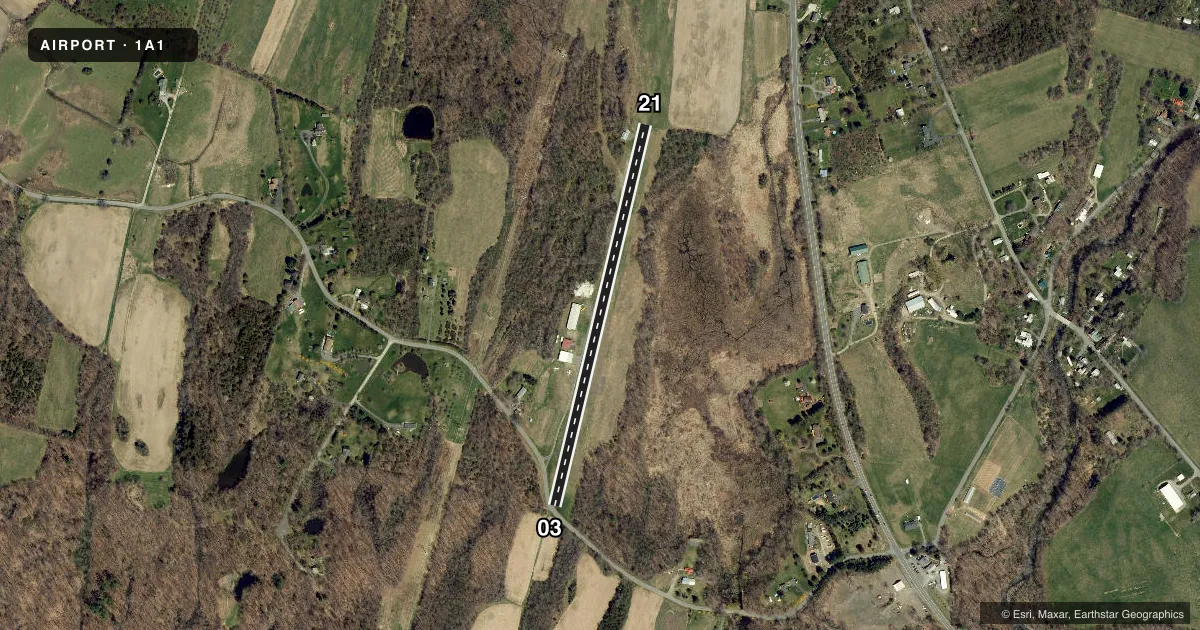
Runways & pattern
Full pagePattern entry · RWY 03
LEFT TRAFFICRunway end performance
| End | TORA | TODA | ASDA | LDA | VGSI | Approach lights | Obstruction |
|---|---|---|---|---|---|---|---|
| 03 | — | — | — | — | — | — | 62', trees, 4' from thr, 119' R of cntrln, slope 0 |
| 21 | — | — | — | — | — | — | 29', tree, 2' from thr, 62' R of cntrln, slope 0 |
Declared distances in feet. TORA = takeoff run available, TODA = takeoff distance, ASDA = accelerate-stop, LDA = landing distance.
Airport sketch
Runways drawn to scale from FAA survey coordinates, rendered over satellite imagery. Not for navigation.
Approaches & charts
Services on the field
Fuel grades, oxygen, maintenance, ramp storage and lighting — as declared to the FAA by the airport operator.
Fuel & services
- Fuel
- Not available
- Airframe repair
- Minor
- Power plant repair
- Minor
- Other services
- AGRI,INSTR
Ramp & ground
- Transient storage
- Tie-down
- Landing fee
- No fee published
- Customs
- Not available
- Wind indicator
- Yes
- Segmented circle
- No
Fuel & FBOs
Cheapest 100LL and Jet A on the field and nearby. Always confirm with the FBO before taxi.
Airport notes
Surface conditions, obstructions, local procedures, lighting outages and other notes published with each FAA cycle.
General notes
- MKD PLINES WEST 0.25 NM, NO OBSTN TO LEFT TFC PAT.
- RY 03 HAS +15 FT ROAD ACROSS BEGINNING OF RY
- RY 21 FIRST 400 FT OF RY DOWNSLOPES 20 FT TO LOW PT OF RY.
- FOR CD CTC ALBANY APCH AT 518-862-2299.
Approach & departure obstructions
- 03CTLNG OBSTN EXCEEDS 45 DEG SLP.
Other notes
- VFR CONDS; OPNS RSTRD TO E OF ARPT; COORD WITH ALBANY CO ATCT.
- MANAGEROR PHONE 518-225-3858
VFR map & nearby airports
VFR sectional. Tap any ICAO chip to open that airport.
Key facts · 1A1
Answer card- ICAO
- 1A1
- Name
- GREEN ACRES
- Location
- LIVINGSTON, NEW YORK
- Elevation
- 297 ft MSL
- Traffic pattern altitude
- 1,297 ft MSL (1,000 AGL)
- Control tower
- Non-towered (use CTAF)
- Total runways
- 1
- Longest runway
- 03/21 · 2,275 ft
- Published ILS approaches
- 0
- Published frequencies
- 1
- Magnetic variation
- 14°
- Current flight rules
- VFR
- Current wind
- 000° at 0 kt
- Favored runway now
- –
Green Acres Airport sits in Livingston, New York. Field elevation is 297 ft MSL. The airport has one runway. Runway 03/21 is 2,275 ft of turf, which makes this a short-field, soft-surface stop for light aircraft. No control tower is published here. CTAF is 122.9.
No ILS approaches are published. Pattern altitude is not published, so use the standard 1,000 ft AGL only if that matches your aircraft and the current published pattern guidance. The field sits in a part of New York where you should pay close attention to local traffic flow and nearby airspace before you launch. Published remarks note power lines west of the field about 0.25 NM away. They also note a road crossing the start of Runway 03. Runway 21 slopes down 20 ft over the first 400 ft. The controlling obstruction for Runway 03 exceeds a 45 degree slope.
No on-field FBOs are listed. Contact the airport operator directly before arrival. The manager can be reached by phone at 518-225-3858. Published remarks also say to coordinate with Albany County Air Traffic Control Tower for operations. Contact Albany Approach at 518-862-2299 for clearance delivery. Check the current FAA Chart Supplement for any published noise or curfew restrictions before flying into the field.