METAR & TAF 1I5
1I5 does not publish a METAR.
Showing the nearest reporting station: KALB (ALBANY INTL) · 25.9 NM away. Conditions at 1I5 may differ.
METAR · KALB
Observed 10:51Z
KALB 261051Z 00000KT 10SM SCT070 BKN250 17/14 A2996 RMK AO2 SLP143 T01720144 $
- Wind
- 000° @ 0 kt
- Visibility
- 10 SM
- Temp / Dew
- 17°C / 14°C
- Altimeter
- 29.96 inHg
- Clouds
- BKN
- Density alt
- 736 ft
- Ceiling
- 25,000 ft AGL
- Rules
- VFR
Airport info & contacts
Manager on record, flight service, ARTCC, attendance schedule and pattern altitude — published by the FAA and refreshed every 28 days.
Location
- From city
- 1 NM NW
- VFR sectional
- NEW YORK
- ARTCC
- ZBW · BOSTON
- NOTAM facility
- BTV (NOTAM-D)
Airport manager
- Name
- ROBERT PETT
- Phone
- 518-253-4859
- Address
- PO BOX 304, FREEHOLD NY 12431
Flight service · Hours
- FSS BTV
- BURLINGTON1-800-WX-BRIEF
- Attendance
- APR-DEC · 0900-DUSK
Frequencies
Tap any row to copy the frequency to your clipboard.
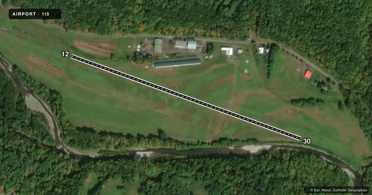
Runways & pattern
Full pagePattern entry · RWY 12
LEFT TRAFFICRunway end performance
| End | TORA | TODA | ASDA | LDA | VGSI | Approach lights | Obstruction |
|---|---|---|---|---|---|---|---|
| 12 | — | — | — | — | — | — | 70', trees, 812' from thr, 85' R of cntrln, slope 8 |
| 30 | — | — | — | — | — | — | 35', trees, 315' from thr, 35' R of cntrln, slope 3 |
Declared distances in feet. TORA = takeoff run available, TODA = takeoff distance, ASDA = accelerate-stop, LDA = landing distance.
Airport sketch
Runways drawn to scale from FAA survey coordinates, rendered over satellite imagery. Not for navigation.
Approaches & charts
Services on the field
Fuel grades, oxygen, maintenance, ramp storage and lighting — as declared to the FAA by the airport operator.
Fuel & services
- Fuel
- Not available
- Airframe repair
- Not available
- Power plant repair
- Not available
- Other services
- GLD,INSTR,TOW
Ramp & ground
- Transient storage
- Tie-down
- Landing fee
- No fee published
- Customs
- Not available
- Wind indicator
- Yes
- Segmented circle
- No
Fuel & FBOs
Cheapest 100LL and Jet A on the field and nearby. Always confirm with the FBO before taxi.
Airport notes
Surface conditions, obstructions, local procedures, lighting outages and other notes published with each FAA cycle.
General notes
- EXTENSIVE GLIDER ACTIVITY, ESPECIALLY ON WEEKENDS.
- RY 12 ORCHARDS 100 FT LEFT & 112 FT RIGHT RY CNTRLN & 59 FT TREES IN APCH TO RY 288 FT FM THLD.
- RGT TFC FOR GLIDERS RY 12 ONLY.
- CONTACT AIRPORT MANAGER FOR FIELD CONDITIONS DEC 1 -APR 1; PH. 518-966-8503
- FOR CD CTC ALBANY APCH AT 518-862-2299.
Runway surface & condition
- 12/30100 FT BY 2640 FT TURF RWY ADJACENT TO PAVED RWY (S EDGE) BEGINNING AT 735 FT FROM RWY 30 THLD.
Approach & departure obstructions
- 1210 FT HIGH FENCE APPROX. PARALLEL TO RWY, 42 FT LT., 50 - 700 FT FRM THSLD.
- 12RGT TFC FOR GLIDERS RY 12 ONLY.
- 12ORCHARDS 100 FT LEFT & 112 FT RIGHT RWY CNTRLN & 67 FT TREES IN APCH TO RWY 812 FT FM THLD. 3 FT HIGH FENCE & WATER PIPE ALG RWY 34 FT LEFT & ACRS RWY SAFETY AREA 200 FT WEST OF THLD.
- 3031 FT TREES IN APCH TO RWY 315 FT FM END OF RWY, 35 FT LEFT OF CNTRLN.
Other notes
- VFR OPNS ONLY.
- 12/30SURFACE BROKEN & SPALLING FOR ENTIRE LENGTH.
VFR map & nearby airports
VFR sectional. Tap any ICAO chip to open that airport.
Key facts · 1I5
Answer card- ICAO
- 1I5
- Name
- FREEHOLD
- Location
- FREEHOLD, NEW YORK
- Elevation
- 440 ft MSL
- Traffic pattern altitude
- 1,440 ft MSL (1,000 AGL)
- Control tower
- Non-towered (use CTAF)
- Total runways
- 1
- Longest runway
- 12/30 · 2,275 ft
- Published ILS approaches
- 0
- Published frequencies
- 1
- Magnetic variation
- 14°
- Current flight rules
- VFR
- Current wind
- 000° at 0 kt
- Favored runway now
- –
Freehold Airport (1I5) sits in Freehold, New York. Field elevation is 440 ft MSL. The airport has one runway. Runway 12/30 is 2,275 ft long and paved with asphalt. There is no control tower. CTAF is 122.85.
No ILS approaches are published here. The field is VFR only. Pattern altitude is not published, so use the current FAA Chart Supplement and local traffic calls before you arrive. The remarks also note extensive glider activity, especially on weekends. Right traffic is used for gliders on runway 12 only. That matters if you are planning a first visit.
Runway condition deserves a close look. The published remarks say the runway surface is broken and spalling along the full length. There are also obstructions near both ends. Trees sit in the approach to runway 12 and runway 30. A fence and a water pipe are also noted near runway 12. There is a turf runway adjacent to the paved runway on the south edge. If you are operating anything larger than a light piston, plan conservatively and verify field conditions before departure. For clearance delivery, contact Albany Approach. For winter operations, call the airport manager for current field conditions before flying in from December 1 through April 1.