METAR & TAF 0B5
0B5 does not publish a METAR.
Showing the nearest reporting station: KORE (ORANGE MUNI) · 10.4 NM away. Conditions at 0B5 may differ.
METAR · KORE
Observed 14:52Z
KORE 271452Z AUTO 00000KT 10SM CLR 24/14 A2986 RMK AO2 SLP110 T02440139 58006
- Wind
- 000° @ 0 kt
- Visibility
- 10 SM
- Temp / Dew
- 24°C / 14°C
- Altimeter
- 29.86 inHg
- Clouds
- CLR
- Density alt
- 1,599 ft
- Ceiling
- Unlimited
- Rules
- VFR
Airport info & contacts
Manager on record, flight service, ARTCC, attendance schedule and pattern altitude — published by the FAA and refreshed every 28 days.
Location
- From city
- 3 NM N
- VFR sectional
- NEW YORK
- ARTCC
- ZBW · BOSTON
- NOTAM facility
- BTV (NOTAM-D)
Airport manager
- Name
- BRYAN CAMDEN
- Phone
- 413-863-0044
- Address
- C/O TOWN OF MONTAGUE, 1 AVENUE A, TURNERS FALLS MA 01376
Flight service · Hours
- FSS BTV
- BURLINGTON1-800-WX-BRIEF
- Attendance
- MON-FRI · 0800-1600
Frequencies
Tap any row to copy the frequency to your clipboard.
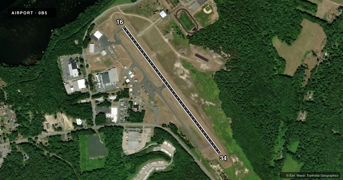
Runways & pattern
Full pagePattern entry · RWY 16
LEFT TRAFFICRunway end performance
| End | TORA | TODA | ASDA | LDA | VGSI | Approach lights | Obstruction |
|---|---|---|---|---|---|---|---|
| 16 | — | — | — | — | PAPI 4-box left(3°) | — | 20', trees, 600' from thr, 130' R of cntrln, slope 20 |
| 34 | — | — | — | — | — | — | 30', trees, 800' from thr, 150' R of cntrln, slope 20 |
Declared distances in feet. TORA = takeoff run available, TODA = takeoff distance, ASDA = accelerate-stop, LDA = landing distance.
Airport sketch
Runways drawn to scale from FAA survey coordinates, rendered over satellite imagery. Not for navigation.
Approaches & charts
Services on the field
Fuel grades, oxygen, maintenance, ramp storage and lighting — as declared to the FAA by the airport operator.
Fuel & services
- Fuel
- 100LLA1
- Oxygen (bottled)
- Not available
- Oxygen (bulk)
- Not available
- Airframe repair
- Major
- Power plant repair
- Major
- Other services
- AFRT,AVNCS,INSTR,RNTL
Ramp & ground
- Transient storage
- Tie-down
- Hangar
- Landing fee
- No fee published
- Customs
- Not available
- Lighting schedule
- SEE RMK
- Beacon schedule
- SS-SR
- Beacon
- White / Green (civil land)(WG)
- Wind indicator
- Yes
- Segmented circle
- No
Fuel & FBOs
Cheapest 100LL and Jet A on the field and nearby. Always confirm with the FBO before taxi.
Airport notes
Surface conditions, obstructions, local procedures, lighting outages and other notes published with each FAA cycle.
General notes
- RWY 16 IS CALM WIND RWY.
- WILDLIFE & BIRDS INVOF ARPT.
- FOR CD CTC BOSTON ARTCC AT 603-879-6859.
- COLD TEMPERATURE AIRPORT. ALTITUDE CORRECTION REQUIRED AT OR BELOW -25C.
Lighting notes
- ACTVT REIL RWY 16; MIRL RWY 16/34 - CTAF.
Fuel notes
- A1FUEL CART CTC AMGR.
Other notes
- ESTAB PRIOR 1959.
- MANAGERAMGR CTC 24 HRS CELL 978-305-2452.
VFR map & nearby airports
VFR sectional. Tap any ICAO chip to open that airport.
Key facts · 0B5
Answer card- ICAO
- 0B5
- Name
- TURNERS FALLS
- Location
- MONTAGUE, MASSACHUSETTS
- Elevation
- 358.7 ft MSL
- Traffic pattern altitude
- 1,358.7 ft MSL (1,000 AGL)
- Control tower
- Non-towered (use CTAF)
- Total runways
- 1
- Longest runway
- 16/34 · 3,200 ft
- Published ILS approaches
- 0
- Published frequencies
- 2
- Magnetic variation
- 15°
- Current flight rules
- VFR
- Current wind
- 000° at 0 kt
- Favored runway now
- –
Turners Falls Airport sits in Montague, Massachusetts. Field elevation is 358.7 ft MSL. It has one runway. The longest is 3,200 ft of asphalt, runway 16/34 with magnetic headings 143° and 323°. There is no control tower. CTAF and UNICOM are both 123.0.
No ILS approaches are published here. Pattern altitude is not published, so use the standard 1,000 ft AGL for light piston traffic unless the current Chart Supplement says otherwise. The field has one on-field FBO, Turners Falls Airport. It carries AVGAS 100LL and JET A. Call (413) 863-0044 for current service details.
A few published remarks matter for planning. Runway 16 is the calm wind runway. Runway 16 also has runway end identifier lights. Medium intensity runway lights are on both runways and are controlled on CTAF. Wildlife and birds are reported in the area, so keep an eye out on departure and arrival. The airport manager can be reached 24 hours a day at 978-305-2452. This is also a cold temperature airport, so altitude correction is required at or below minus 25 degrees Celsius. For IFR clearance delivery, contact Boston ARTCC. First-time pilots should also verify any local noise or operating notes in the current Chart Supplement before flying in.