METAR & TAF KEEN
Current METAR
Observed 12:56Z
KEEN 271256Z AUTO 00000KT 10SM CLR 18/13 A2988 RMK AO2 SLP117 T01780128
- Wind
- 000° @ 0 kt
- Visibility
- 10 SM
- Temp / Dew
- 18°C / 13°C
- Altimeter
- 29.88 inHg
- Clouds
- CLR
- Density alt
- 1,015 ft
- Ceiling
- Unlimited
- Rules
- VFR
Airport info & contacts
Manager on record, flight service, ARTCC, attendance schedule and pattern altitude — published by the FAA and refreshed every 28 days.
Location
- From city
- 2 NM S
- VFR sectional
- NEW YORK
- ARTCC
- ZBW · BOSTON
- NOTAM facility
- EEN (NOTAM-D)
Airport manager
- Name
- RYAN COOLEY
- Phone
- 603-357-9835
- Address
- 80 AIRPORT RD, KEENE NH 03431
Flight service · Hours
- FSS BGR
- BANGOR1-800-WX-BRIEF
- Attendance
- MON-FRI · 0700-1900
- SAT-SUN · 0700-1700
Frequencies
Tap any row to copy the frequency to your clipboard.
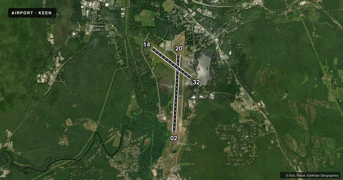
Runways & pattern
Full pagePattern entry · RWY 02
LEFT TRAFFIC| Runway | Heading (°M) | Length | Surface | Traffic |
|---|---|---|---|---|
| 02/20 | 348° / 168° | 6,201 ft | ASPH | Standard L |
| 14/32 | 112° / 292° | 4,001 ft | ASPH | Standard L |
Runway end performance
| End | TORA | TODA | ASDA | LDA | VGSI | Approach lights | Obstruction |
|---|---|---|---|---|---|---|---|
| 02 | — | — | — | — | PAPI 4-box left(3°) | MALSR | 70', tree, 974' from thr, 540' R of cntrln, slope 11 |
| 20 | — | — | — | — | PAPI 4-box left(3°) | — | 112', trees, 1665' from thr, 541' R of cntrln, slope 13 |
| 14 | — | — | — | — | — | — | 10', trees, 355' from thr, 37' R of cntrln, slope 15 |
| 32 | — | — | — | — | — | — | 48', trees, 522' from thr, 101' R of cntrln, slope 6 |
Declared distances in feet. TORA = takeoff run available, TODA = takeoff distance, ASDA = accelerate-stop, LDA = landing distance.
Airport sketch
Runways drawn to scale from FAA survey coordinates, rendered over satellite imagery. Not for navigation.
Approaches & charts
ILS · 1
Services on the field
Fuel grades, oxygen, maintenance, ramp storage and lighting — as declared to the FAA by the airport operator.
Fuel & services
- Fuel
- 100LLA
- Oxygen (bottled)
- HIGH/LOW
- Oxygen (bulk)
- HIGH/LOW
- Airframe repair
- Major
- Power plant repair
- Major
- Other services
- CHTR,INSTR,RNTL,SALES
Ramp & ground
- Transient storage
- Tie-down
- Hangar
- Landing fee
- Yes
- Customs
- Not available
- Lighting schedule
- SEE RMK
- Beacon schedule
- SS-SR
- Beacon
- White / Green (civil land)(WG)
- Wind indicator
- Lighted
- Segmented circle
- Yes
Fuel & FBOs
Cheapest 100LL and Jet A on the field and nearby. Always confirm with the FBO before taxi.
Airport notes
Surface conditions, obstructions, local procedures, lighting outages and other notes published with each FAA cycle.
General notes
- WILDLIFE ON & INVOF ARPT.
- NOISE ABATEMENT PROC: HEL TFC AVOID RESIDENTIAL AREAS DRCTLY N OF RWY 02-20 & SW OF ARPT. HEL TFC LIMIT MULT CLSD PAT OPS.
- FOR CD IF UNA TO CTC ON FSS FREQ, CTC BOSTON ARTCC AT 603-879-6859.
- COLD TEMPERATURE AIRPORT. ALTITUDE CORRECTION REQUIRED AT OR BELOW -20C.
- NO ENG RUN-UPS ON TRML NW APN.
- GRASS AREAS NOT MNTND FOR TKOFS & LDGS.
Lighting notes
- ACTVT MALSR RWY 02; HIRL RWY 02/20; MIRL RWY 14/32 - CTAF.
Fuel notes
- 100LL100LL AVBL 24 HRS WITH CREDIT CARD. FOR JET FUEL AFT HRS CALL 603-357-7600.
Approach & departure obstructions
- 20PAPI OTS INDEFLY.
- 32APCH RATIO 25:1 TO DTHR.
Other notes
- ESTAB PRIOR TO 1959.
- LDG FEE FOR ALL TURBINE PWRD ACFT.
VFR map & nearby airports
VFR sectional. Tap any ICAO chip to open that airport.
Key facts · KEEN
Answer card- ICAO
- KEEN
- Name
- DILLANT/HOPKINS
- Location
- KEENE, NEW HAMPSHIRE
- Elevation
- 488 ft MSL
- Traffic pattern altitude
- 1,488 ft MSL (1,000 AGL)
- Control tower
- Non-towered (use CTAF)
- Total runways
- 2
- Longest runway
- 02/20 · 6,201 ft
- Published ILS approaches
- 1
- Published frequencies
- 2
- Magnetic variation
- 15°
- Current flight rules
- VFR
- Current wind
- 000° at 0 kt
- Favored runway now
- –
Dillant/Hopkins in Keene, New Hampshire sits at 488 ft MSL. It has two asphalt runways. The longest is 02/20 at 6,201 ft. The field is non-towered. CTAF and UNICOM are both 123.0. An ILS is available to runway 02. Pattern altitude is not published, so use the standard 1,000 ft AGL for light piston traffic unless the current Chart Supplement says otherwise.
Monadnock Aviation is on the field. It carries 100LL and Jet A. 100LL is available 24 hours with credit card. The airport has wildlife on and near the field. Helicopter traffic should avoid the residential areas north of runway 02/20 and southwest of the airport. Helicopter traffic is limited to multiple closed pattern operations. The field is also a cold temperature airport, so altitude correction is required at or below minus 20 degrees Celsius.
Runway 02 uses MALSR. Runways 02 and 20 have high intensity lighting. Runways 14 and 32 have medium intensity lighting on CTAF. Runway 20 has a PAPI that is out of service indefinitely. There is also an obstruction note for runway 32. Check the current Chart Supplement before arrival if you need the exact displaced threshold details or any other operational limits. No engine run-ups are allowed on the terminal northwest apron.