METAR & TAF KLEB
Current METAR
Observed 05:53Z
KLEB 270553Z AUTO 00000KT 10SM CLR 13/13 A2986 RMK AO2 SLP102 T01330128 10211 20122 56006
- Wind
- 000° @ 0 kt
- Visibility
- 10 SM
- Temp / Dew
- 13°C / 13°C
- Altimeter
- 29.86 inHg
- Clouds
- CLR
- Density alt
- 582 ft
- Ceiling
- Unlimited
- Rules
- VFR
Airport info & contacts
Manager on record, flight service, ARTCC, attendance schedule and pattern altitude — published by the FAA and refreshed every 28 days.
Location
- From city
- 3 NM W
- VFR sectional
- NEW YORK
- ARTCC
- ZBW · BOSTON
- NOTAM facility
- LEB (NOTAM-D)
Airport manager
- Name
- CARL GROSS
- Phone
- 603-298-8878
- Address
- 5 AIRPARK RD, WEST LEBANON NH 03784
Flight service · Hours
- FSS BGR
- BANGOR1-800-WX-BRIEF
- Attendance
- 0600-2200
Frequencies
Tap any row to copy the frequency to your clipboard.
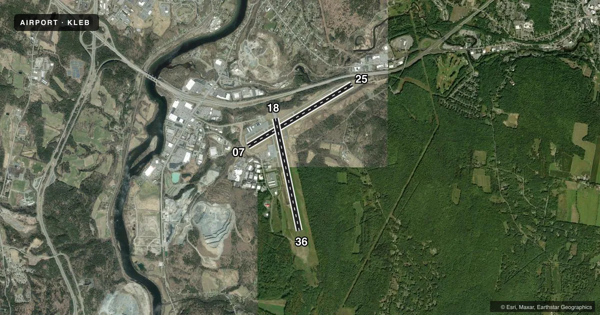
Runways & pattern
Full pagePattern entry · RWY 07
LEFT TRAFFIC| Runway | Heading (°M) | Length | Surface | Traffic |
|---|---|---|---|---|
| 07/25 | 43° / 223° | 5,496 ft | ASPH | Standard L |
| 18/36 | 152° / 332° | 5,200 ft | ASPH | Standard L |
Runway end performance
| End | TORA | TODA | ASDA | LDA | VGSI | Approach lights | Obstruction |
|---|---|---|---|---|---|---|---|
| 07 | — | — | — | — | PAPI 4-box left(4°) | — | 16', tree, 316' from thr, 213' R of cntrln, slope 7 |
| 25 | — | — | — | — | PAPI 4-box right(4°) | — | 74', tree, 537' from thr, 286' R of cntrln, slope 4 |
| 18 | — | — | — | — | — | — | 11', trees, 355' from thr, 331' R of cntrln, slope 14 |
| 36 | — | — | — | — | PAPI 4-box left(3.75°) | — | 107', trees, 667' from thr, 521' R of cntrln, slope 4 |
Declared distances in feet. TORA = takeoff run available, TODA = takeoff distance, ASDA = accelerate-stop, LDA = landing distance.
Airport sketch
Runways drawn to scale from FAA survey coordinates, rendered over satellite imagery. Not for navigation.
Approaches & charts
ILS · 1
Services on the field
Fuel grades, oxygen, maintenance, ramp storage and lighting — as declared to the FAA by the airport operator.
Fuel & services
- Fuel
- 100LLA
- Oxygen (bulk)
- High pressure
- Airframe repair
- Major
- Power plant repair
- Major
- Other services
- AMB,CHTR,INSTR,SURV
Ramp & ground
- Transient storage
- Tie-down
- Hangar
- Landing fee
- Yes
- Customs
- Not available
- Lighting schedule
- SEE RMK
- Beacon schedule
- SS-SR
- Beacon
- White / Green (civil land)(WG)
- Wind indicator
- Lighted
- Segmented circle
- Yes
Fuel & FBOs
Cheapest 100LL and Jet A on the field and nearby. Always confirm with the FBO before taxi.
Airport notes
Surface conditions, obstructions, local procedures, lighting outages and other notes published with each FAA cycle.
General notes
- TREES 5600 FT E OF ARPT, ELEV 1253 FT; TREES 6700 FT E OF ARPT, ELEV 1275 FT; TREES INDCD ARE OBSTN LGTD.
- OCNL WILDLIFE ACT ON & NR ARPT.
- HANG GLDR OPS INVOF MT ASCUTNEY, VT 20 MI SW LEB SFC-8000 FT DAYS.
- NO PLAS OR TGLS 0000-0700.
- NOISE ABATEMENT PROCS IN EFCT, CTC AMGR. ALL ARR/DEP ACFT FLW MANUFACTURER'S RCMDD PROC FOR QUIET OPN & MNM NOISE.
- COLD TEMPERATURE AIRPORT. ALTITUDE CORRECTION REQUIRED AT OR BELOW -19C.
- FOR CD IF TWR CLSD & UNA TO CTC FSS FREQ, CTC BOSTON ARTCC AT 603-879-6859.
- HOT AIR BALLOON ACT 8.6 NM W OF ARPT.
Lighting notes
- ACTVT REIL RWY 07 & 25; PAPI RWY 07, 25 & 36; MIRL RWY 07/25; HIRL RWY 18/36 - CTAF.
Fuel notes
- AFOR FUEL AFT HRS CALL 603-298-6555.
Approach & departure obstructions
- 18FENCE 125 FT FM RWY END, 425 FT RIGHT.
- 2530 FT TREE 145 FT FM RWY END, 179 FT RIGHT.
- 36TREES 4000 FT W OF EOR, 970 FT MSL, OBST LGTD. TREES 1500 FT SW OF EOR, 800 FT MSL, OBST LGTD.
Other notes
- THIS AIRPORT HAS BEEN SURVEYED BY THE NATIONAL GEODETIC SURVEY.
- ESTAB PRIOR TO 1959.
- LDG FEES EXCP FOR NON-COML SNGL ENG.
VFR map & nearby airports
VFR sectional. Tap any ICAO chip to open that airport.
Key facts · KLEB
Answer card- ICAO
- KLEB
- Name
- LEBANON MUNI
- Location
- LEBANON, NEW HAMPSHIRE
- Elevation
- 603.3 ft MSL
- Traffic pattern altitude
- 1,603.3 ft MSL (1,000 AGL)
- Control tower
- Towered · 0600-2200
- Total runways
- 2
- Longest runway
- 07/25 · 5,496 ft
- Published ILS approaches
- 1
- Published frequencies
- 6
- Magnetic variation
- 16°
- Current flight rules
- VFR
- Current wind
- 000° at 0 kt
- Favored runway now
- –
Lebanon Muni sits in Lebanon, New Hampshire. Field elevation is 603.3 ft MSL. The airport has two asphalt runways. The longest is 5,496 ft on 07/25. The tower is open from 0600 to 2200. One ILS is published for runway 18. Pattern altitude is not published. Use 1,000 ft AGL for light piston traffic unless the current Chart Supplement says otherwise. That puts the pattern at about 1,603 ft MSL here.
Granite Air Center is on the field. It carries 100LL, Jet A and Jet A Prist. Call the FBO directly for current services or after-hours fuel. Published remarks also note noise abatement procedures. Contact the airport manager for the current quiet-operation guidance before you go. Wildlife activity is also reported on and near the airport.
This is a controlled field with published lighting on both runways. Runway 07 and 25 have medium intensity lights. Runway 18/36 has high intensity lights. PAPI is available on 07, 25 and 36. Runway 36 also has tree obstructions west and southwest of the departure end. Runway 25 has a tree close off the right side near the end. Check the current Chart Supplement and plan for the published procedures before arrival.