METAR & TAF 76B
76B does not publish a METAR.
Showing the nearest reporting station: KIZG (WHITE MOUNTAIN RGNL) · 14.2 NM away. Conditions at 76B may differ.
METAR · KIZG
Observed 09:54Z
KIZG 260954Z AUTO 00000KT 10SM FEW002 09/08 A3000 RMK AO2 SLP159 T00940078 $
- Wind
- 000° @ 0 kt
- Visibility
- 10 SM
- Temp / Dew
- 9°C / 8°C
- Altimeter
- 30.00 inHg
- Clouds
- FEW
- Density alt
- -487 ft
- Ceiling
- Unlimited
- Rules
- VFR
Airport info & contacts
Manager on record, flight service, ARTCC, attendance schedule and pattern altitude — published by the FAA and refreshed every 28 days.
Location
- From city
- 1 NM NE
- VFR sectional
- NEW YORK
- ARTCC
- ZBW · BOSTON
- NOTAM facility
- BGR (NOTAM-D)
Airport manager
- Name
- MATTHEW MCFADDEN
- Phone
- 207-232-2594
- Address
- PO BOX 14, DENMARK ME 04022
Flight service · Hours
- FSS BGR
- BANGOR1-800-WX-BRIEF
- Attendance
- JUNE-OCT · MON-SAT · 0900-DUSK
- JUNE-OCT · SUN · Unattended
Frequencies
Tap any row to copy the frequency to your clipboard.
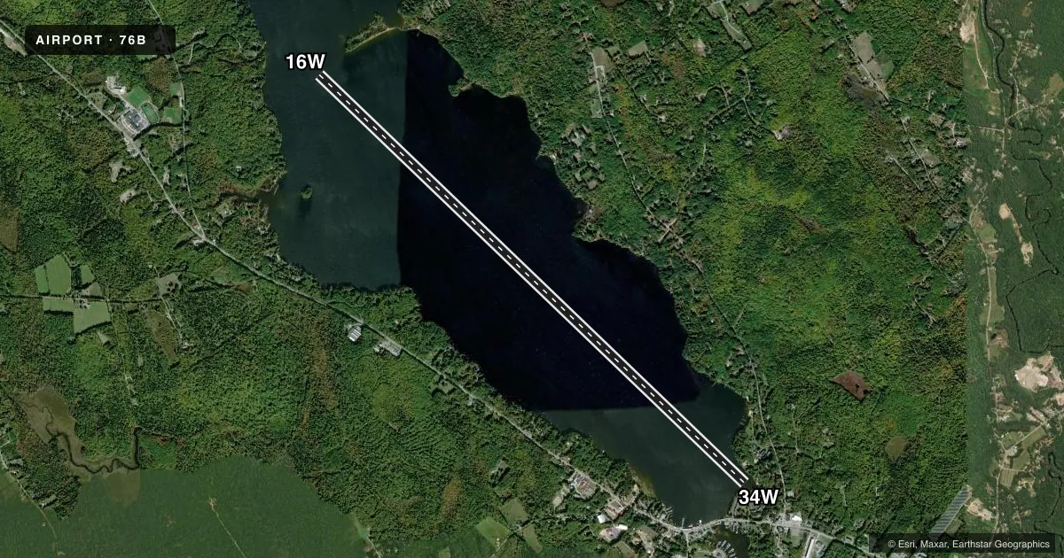
Runways & pattern
Full pagePattern entry · RWY 16W
LEFT TRAFFICAirport sketch
Runways drawn to scale from FAA survey coordinates, rendered over satellite imagery. Not for navigation.
Approaches & charts
Services on the field
Fuel grades, oxygen, maintenance, ramp storage and lighting — as declared to the FAA by the airport operator.
Fuel & services
- Fuel
- 100LL
- Airframe repair
- Not available
- Power plant repair
- Not available
Ramp & ground
- Transient storage
- Not published
- Landing fee
- No fee published
- Wind indicator
- Yes
- Segmented circle
- No
Fuel & FBOs
Cheapest 100LL and Jet A on the field and nearby. Always confirm with the FBO before taxi.
Airport notes
Surface conditions, obstructions, local procedures, lighting outages and other notes published with each FAA cycle.
General notes
- FOR CD CTC PORTLAND APCH AT 207-874-7320, WHEN APCH CLSD CTC BOSTON ARTCC AT 603-879-6859.
- MONITOR CTAF WITHIN 5 NM OF NAPLES.
Fuel notes
- 100LLFUEL AVBL MON-SAT 0900-1900 ONLY.
Other notes
- FILED FOR RECORD PURPOSES. EXISTED PRIOR TO 1959.
- WIND SOCK AT DOCK.
VFR map & nearby airports
VFR sectional. Tap any ICAO chip to open that airport.
Key facts · 76B
Answer card- ICAO
- 76B
- Name
- LONG LAKE
- Location
- NAPLES, MAINE
- Elevation
- 268 ft MSL
- Traffic pattern altitude
- 1,268 ft MSL (1,000 AGL)
- Control tower
- Non-towered (use CTAF)
- Total runways
- 1
- Longest runway
- 16W/34W · 15,000 ft
- Published ILS approaches
- 0
- Published frequencies
- 1
- Magnetic variation
- 17°
- Current flight rules
- VFR
- Current wind
- 000° at 0 kt
- Favored runway now
- –
Long Lake Airport (76B) sits in Naples, Maine. Field elevation is 268 ft MSL. The airport has one runway. It is a 15,000 ft water runway, 16W/34W, with magnetic headings of 134° and 314°. There is no control tower. CTAF is 122.9.
No ILS approaches are published here. Pattern altitude is not published, so use standard light piston practice unless the current Chart Supplement says otherwise. The FAA remarks say to monitor the common traffic advisory frequency within 5 NM of Naples. That matters here because this is a water runway with traffic that may be spread out. The wind sock is located at the dock. 100LL fuel is available Monday through Saturday from 0900 to 1900 only. For clearance delivery, contact Portland Approach at 207-874-7320. When approach is closed, contact Boston ARTCC at 603-879-6859.
There are no on-field FBOs listed. If you need current services, call the airport operator or the field directly before arrival. Pilots should also plan for the magnetic variation of 17° when reviewing runway orientation and local references.