METAR & TAF 1B5
1B5 does not publish a METAR.
Showing the nearest reporting station: KHIE (MOUNT WASHINGTON RGNL) · 13.6 NM away. Conditions at 1B5 may differ.
METAR · KHIE
Observed 17:52Z
KHIE 261752Z AUTO 09005KT 10SM SCT060 29/13 A2989 RMK AO2 SLP118 T02890128 10289 20161 56020
- Wind
- 090° @ 5 kt
- Visibility
- 10 SM
- Temp / Dew
- 29°C / 13°C
- Altimeter
- 29.89 inHg
- Clouds
- SCT
- Density alt
- 2,926 ft
- Ceiling
- Unlimited
- Rules
- VFR
Airport info & contacts
Manager on record, flight service, ARTCC, attendance schedule and pattern altitude — published by the FAA and refreshed every 28 days.
Location
- From city
- 2 NM S
- VFR sectional
- MONTREAL
- ARTCC
- ZBW · BOSTON
- NOTAM facility
- BGR (NOTAM-D)
Airport manager
- Name
- JAMES R DAVID
- Phone
- 603-921-1588
- Address
- P.O. BOX 898, FRANCONIA NH 03580
Flight service · Hours
- FSS BGR
- BANGOR1-800-WX-BRIEF
- Attendance
- MAY-OCT · SAT-SUN · 0900-1800
Frequencies
Tap any row to copy the frequency to your clipboard.
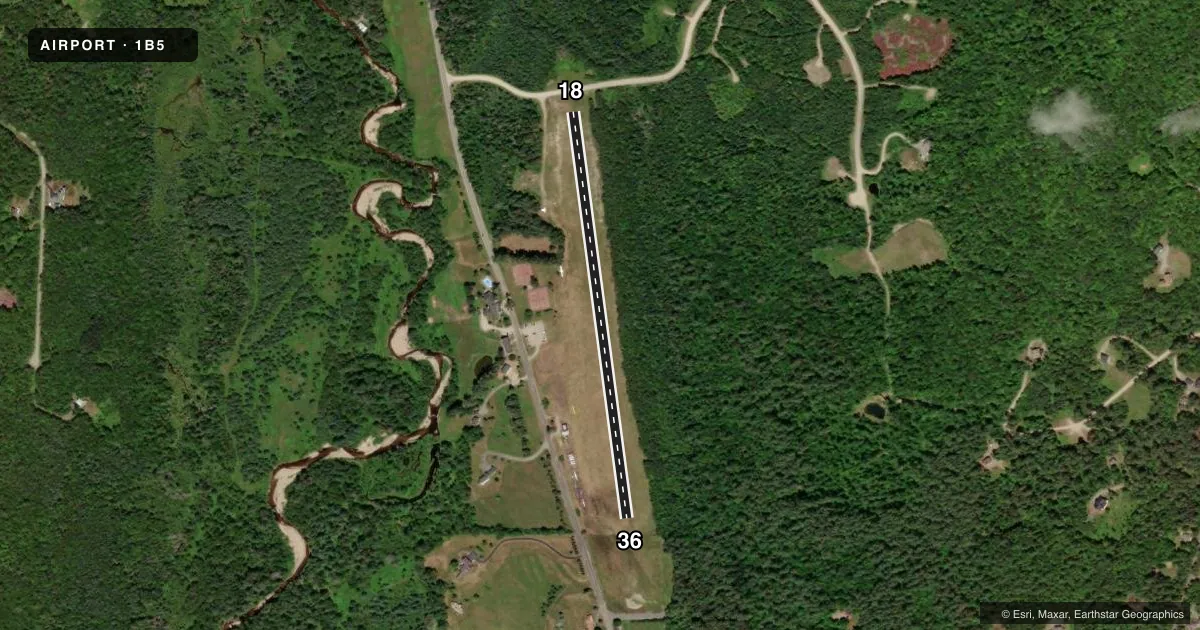
Runways & pattern
Full pagePattern entry · RWY 18
LEFT TRAFFICRunway end performance
| End | TORA | TODA | ASDA | LDA | VGSI | Approach lights | Obstruction |
|---|---|---|---|---|---|---|---|
| 18 | — | — | — | — | — | — | 61', trees, 226' from thr, 147' R of cntrln, slope 3 |
| 36 | — | — | — | — | — | — | 56', trees, 504' from thr, 135' R of cntrln, slope 9 |
Declared distances in feet. TORA = takeoff run available, TODA = takeoff distance, ASDA = accelerate-stop, LDA = landing distance.
Airport sketch
Runways drawn to scale from FAA survey coordinates, rendered over satellite imagery. Not for navigation.
Approaches & charts
Services on the field
Fuel grades, oxygen, maintenance, ramp storage and lighting — as declared to the FAA by the airport operator.
Fuel & services
- Fuel
- Not available
- Oxygen (bottled)
- Not available
- Oxygen (bulk)
- Not available
- Airframe repair
- Not available
- Power plant repair
- Not available
- Other services
- GLD,INSTR,RNTL,TOW
Ramp & ground
- Transient storage
- Tie-down
- Landing fee
- No fee published
- Customs
- Not available
- Wind indicator
- Yes
- Segmented circle
- Yes
Fuel & FBOs
Cheapest 100LL and Jet A on the field and nearby. Always confirm with the FBO before taxi.
Airport notes
Surface conditions, obstructions, local procedures, lighting outages and other notes published with each FAA cycle.
General notes
- RWY SOFT IN SPRING.
- FOR ARPT CONDS CALL 603-823-5034.
- AVOID FLYING OVR RESL AREA AT DER 18 DURG BOTH TKOF AND LDG; AVOID LOW ALT AND/OR HIGH PWR SETTINGS IN THIS AREA.
- WILDLIFE ON & INVOF ARPT.
- IN CASE OF EMERG CTC NEW HAMPSHIRE STATE POLICE 800-525-5555.
- GLDR OPNS INVOF ARPT.
- FOR CD CTC BOSTON ARTCC AT 603-879-6859.
- 4 FT TALL FENCE 92 FT FM RWY 36 L TO R OF CNTRLN.
- RENTAL BICYCLES AVBL AT FRANCONIA INN.
- TKOFS & LDGS NOT ADZD FM DUSK TO 0900 FOR VOLUNTARY NOISE BATEMENT.
Runway surface & condition
- 18/36FST 200 FT OF RWY 18 ROUGH.
Approach & departure obstructions
- 36L PAT FOR GLDRS.
Other notes
- VFR OPNS ONLY.
- 1ALSO ATNDD ON WKDAY HOLS. CTC AMGR FOR NON-HOL WKDAY ATNDNC.
- OWNERFRANCONIASOARING@GMAIL.COM.
VFR map & nearby airports
VFR sectional. Tap any ICAO chip to open that airport.
Key facts · 1B5
Answer card- ICAO
- 1B5
- Name
- FRANCONIA
- Location
- FRANCONIA, NEW HAMPSHIRE
- Elevation
- 975 ft MSL
- Traffic pattern altitude
- 1,975 ft MSL (1,000 AGL)
- Control tower
- Non-towered (use CTAF)
- Total runways
- 1
- Longest runway
- 18/36 · 2,300 ft
- Published ILS approaches
- 0
- Published frequencies
- 2
- Magnetic variation
- 16°
- Current flight rules
- VFR
- Current wind
- 090° at 5 kt
- Favored runway now
- RWY 18
Franconia Airport sits in Franconia, New Hampshire at 975 ft MSL. It has one runway. Runway 18/36 is a 2,300 ft turf strip. There is no control tower. CTAF and UNICOM are both 122.8. No ILS approaches are published, so plan for VFR only. The field is in a mountain area with glider activity nearby. Keep a close eye on traffic and stay sharp on wind and terrain.
Pattern altitude is not published. Use the standard 1,000 ft AGL pattern unless local conditions or the current Chart Supplement say otherwise. That puts the traffic pattern at about 1,975 ft MSL based on the field elevation. The published remarks matter here. The first 200 feet of runway 18 is rough. There is also a 4 foot fence 92 feet from runway 36, left of centerline to right of centerline. Runway 18 has a residential area off the departure end. Avoid low altitude and high power settings over that area. The runway is soft in spring. Takeoffs and landings are not advised from dusk to 0900 for voluntary noise abatement. No on-field FBOs are listed, so verify services with the airport operator or call the field directly before you go.