METAR & TAF KCDA
Current METAR
Observed 13:35Z
KCDA 271335Z AUTO 00000KT 10SM CLR 20/14 A2989 RMK AO2 T02030136
- Wind
- 000° @ 0 kt
- Visibility
- 10 SM
- Temp / Dew
- 20°C / 14°C
- Altimeter
- 29.89 inHg
- Clouds
- CLR
- Density alt
- 2,110 ft
- Ceiling
- Unlimited
- Rules
- VFR
Airport info & contacts
Manager on record, flight service, ARTCC, attendance schedule and pattern altitude — published by the FAA and refreshed every 28 days.
Location
- From city
- 3 NM N
- VFR sectional
- MONTREAL
- Pattern altitude
- 1,012 ft AGL · 2,200 ft MSL
- ARTCC
- ZBW · BOSTON
- NOTAM facility
- BTV (NOTAM-D)
Airport manager
- Name
- CHRIS BEITZEL
- Phone
- 802-272-7725
- Address
- 219 N MAIN ST, BARRE VT 05641
Flight service · Hours
- FSS BTV
- BURLINGTON1-800-WX-BRIEF
- Attendance
- JAN-DEC · MON-FRI · 0700-1530
Frequencies
Tap any row to copy the frequency to your clipboard.
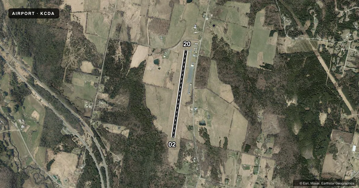
Runways & pattern
Full pagePattern entry · RWY 02
LEFT TRAFFICRunway end performance
| End | TORA | TODA | ASDA | LDA | VGSI | Approach lights | Obstruction |
|---|---|---|---|---|---|---|---|
| 02 | — | — | — | — | — | — | 40', trees, 0' from thr, 208' R of cntrln, slope 0 |
| 20 | — | — | — | — | — | — | 33', trees, 450' from thr, 190' R of cntrln, slope 7 |
Declared distances in feet. TORA = takeoff run available, TODA = takeoff distance, ASDA = accelerate-stop, LDA = landing distance.
Airport sketch
Runways drawn to scale from FAA survey coordinates, rendered over satellite imagery. Not for navigation.
Approaches & charts
Services on the field
Fuel grades, oxygen, maintenance, ramp storage and lighting — as declared to the FAA by the airport operator.
Fuel & services
- Fuel
- Not available
- Oxygen (bottled)
- Not available
- Oxygen (bulk)
- Not available
Ramp & ground
- Transient storage
- Tie-down
- Landing fee
- No fee published
- Customs
- Not available
- Lighting schedule
- SEE RMK
- Beacon schedule
- SEE RMK
- Beacon
- White / Green (civil land)(WG)
- Wind indicator
- Lighted
- Segmented circle
- Yes
Fuel & FBOs
Cheapest 100LL and Jet A on the field and nearby. Always confirm with the FBO before taxi.
Airport notes
Surface conditions, obstructions, local procedures, lighting outages and other notes published with each FAA cycle.
General notes
- RWY CONDS NOT MNT WHEN UNATNDD.
- BRING OWN TIE DOWN ROPES.
- FOR EMERG ACFT MAINT CALL 802-334-5001.
- DEER & WILDLIFE ON & INVOF ARPT.
- BALD EAGLES ROOSTING INVOF COMPOST OPN LCTD 600 FT E OF RWY 20 THR YEAR-ROUND.
- FOR CD CTC BOSTON ARTCC AT 603-879-6859.
Lighting notes
- ACTVT ARPT ROTG BCN - CTAF.
- ACTVT REIL RWY 02; MIRL RWY 02/20 - CTAF.
Approach & departure obstructions
- 0255 FT TREES, 0-199 FT, 197 FT L.
- 02CTLG OBSTN EXCEEDS 45 DEG SLP.
Other notes
- MANAGERON SITE CTC 802-595-2496.
- 02/20EXTSV CRACKING.
VFR map & nearby airports
VFR sectional. Tap any ICAO chip to open that airport.
Key facts · KCDA
Answer card- ICAO
- KCDA
- Name
- CALEDONIA COUNTY
- Location
- LYNDONVILLE, VERMONT
- Elevation
- 1,187.6 ft MSL
- Traffic pattern altitude
- 2,199.6 ft MSL (1,012 AGL)
- Control tower
- Non-towered (use CTAF)
- Total runways
- 1
- Longest runway
- 02/20 · 3,302 ft
- Published ILS approaches
- 0
- Published frequencies
- 2
- Magnetic variation
- 16°
- Current flight rules
- VFR
- Current wind
- 000° at 0 kt
- Favored runway now
- –
Caledonia County Airport (KCDA) sits in Lyndonville, Vermont. Field elevation is 1,187.6 ft MSL. The airport has one runway. Runway 02/20 is 3,302 ft long with asphalt pavement. There is no control tower. CTAF and UNICOM are both 122.8. Pattern altitude is 1,012 ft AGL, which is 2,199.6 ft MSL.
No ILS approaches are published here. The field is served by Caledonia County Airport on the field. It carries 100LL. For clearance delivery, contact Boston ARTCC at 603-879-6859. The rotating beacon is activated by CTAF. Runway 02 has REIL activated by CTAF. Runway 02/20 has medium intensity runway lights activated by CTAF.
A first-time pilot should pay attention to the runway 02 end. Published remarks note 55-foot trees close to that threshold. The cataloged obstacle exceeds a 45 degree slope on runway 02. Runway 02/20 also has extensive cracking. Deer and other wildlife are reported on and near the airport. Runway conditions are not maintained when unattended. Bring your own tie down ropes. If you need local help, the on-site contact is 802-595-2496.