METAR & TAF 0B7
0B7 does not publish a METAR.
Showing the nearest reporting station: KMPV (EDWARD F KNAPP STATE) · 12.5 NM away. Conditions at 0B7 may differ.
METAR · KMPV
Observed 16:51Z
KMPV 271651Z AUTO 12004KT 10SM CLR 27/13 A2986 RMK AO2 SLP106 T02720128
- Wind
- 120° @ 4 kt
- Visibility
- 10 SM
- Temp / Dew
- 27°C / 13°C
- Altimeter
- 29.86 inHg
- Clouds
- CLR
- Density alt
- 3,337 ft
- Ceiling
- Unlimited
- Rules
- VFR
Airport info & contacts
Manager on record, flight service, ARTCC, attendance schedule and pattern altitude — published by the FAA and refreshed every 28 days.
Location
- From city
- 2 NM E
- VFR sectional
- MONTREAL
- ARTCC
- ZBW · BOSTON
- NOTAM facility
- BTV (NOTAM-D)
Airport manager
- Name
- TOM ANDERSON
- Phone
- 802-496-2290
- Address
- PO BOX 123, WARREN VT 05674
Flight service · Hours
- FSS BTV
- BURLINGTON1-800-WX-BRIEF
- Attendance
- MAY-OCT · 0900-1800
Frequencies
Tap any row to copy the frequency to your clipboard.
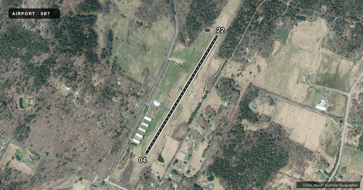
Runways & pattern
Full pagePattern entry · RWY 04
RIGHT TRAFFICRunway end performance
| End | TORA | TODA | ASDA | LDA | VGSI | Approach lights | Obstruction |
|---|---|---|---|---|---|---|---|
| 04 | — | — | — | — | — | — | 60', trees, 201' from thr, 114' R of cntrln, slope 0 |
| 22 | — | — | — | — | — | — | 65', trees, 235' from thr, 135' R of cntrln, slope 0 |
Declared distances in feet. TORA = takeoff run available, TODA = takeoff distance, ASDA = accelerate-stop, LDA = landing distance.
Airport sketch
Runways drawn to scale from FAA survey coordinates, rendered over satellite imagery. Not for navigation.
Approaches & charts
Services on the field
Fuel grades, oxygen, maintenance, ramp storage and lighting — as declared to the FAA by the airport operator.
Fuel & services
- Fuel
- 100LL
- Other services
- GLD,INSTR,RNTL,TOW
Ramp & ground
- Transient storage
- Tie-down
- Landing fee
- No fee published
- Customs
- Not available
- Wind indicator
- Yes
- Segmented circle
- Yes
Fuel & FBOs
Cheapest 100LL and Jet A on the field and nearby. Always confirm with the FBO before taxi.
Airport notes
Surface conditions, obstructions, local procedures, lighting outages and other notes published with each FAA cycle.
General notes
- EXTENSIVE GLIDER ACTIVITY ON ARPT SFC TO 18000 FT DALGT HOURS.
- ARPT CLSD NOV-APR.
- NO LINE OF SIGHT BTN RY ENDS.
- TGLS NA.
- GRASS AREAS NOT AUTHORIZED FOR TAXI, TAKEOFFS & LDGS WITHOUT FIRST CHECKING UNICOM OR MANAGEMENT FOR FIELD CONDS.
- FOR CD CTC BURLINGTON APCH AT 802-657-4413, WHEN APCH CLSD CTC BOSTON ARTCC AT 603-879-6859.
Fuel notes
- 100LLSELF SVC ONLY DURG ATNDD HRS.
Approach & departure obstructions
- 0460-70 FT TREES ALG BOTH SIDES OF RWY N 400 FT.
- 22TREES & TRRN MAY CAUSE UNUSUAL CROSSWIND CONDS.
Other notes
- SEE AIRSPACE CASE 97-ANE-41-NRA.
- ONLY TFC PAT INDICATORS NEAR WINDSOCK, NO CRC.
VFR map & nearby airports
VFR sectional. Tap any ICAO chip to open that airport.
Key facts · 0B7
Answer card- ICAO
- 0B7
- Name
- WARREN-SUGARBUSH
- Location
- WARREN, VERMONT
- Elevation
- 1,470 ft MSL
- Traffic pattern altitude
- 2,470 ft MSL (1,000 AGL)
- Control tower
- Non-towered (use CTAF)
- Total runways
- 1
- Longest runway
- 04/22 · 2,575 ft
- Published ILS approaches
- 0
- Published frequencies
- 2
- Magnetic variation
- 16°
- Current flight rules
- VFR
- Current wind
- 120° at 4 kt
- Favored runway now
- RWY 04
Warren-Sugarbush (0B7) sits in Warren, Vermont at 1,470 ft MSL. The field has one runway, 04/22, which is 2,575 ft long. There is no control tower. CTAF and UNICOM are both 123.0. No ILS approaches are published here.
Pattern altitude is not published. Use the standard 1,000 ft AGL unless the current Chart Supplement or airport operator says otherwise. That puts the light piston pattern at 2,470 ft MSL based on the field elevation, but verify before you fly. Clearance delivery goes through Burlington Approach at 802-657-4413. When approach is closed, contact Boston ARTCC at 603-879-6859.
There are no on-field FBOs listed. Self-serve 100LL is available only during attended hours, so plan ahead and confirm current field status before arrival. The airport is closed from November through April. Touch-and-go landings are not authorized. Grass areas are not authorized for taxi, takeoff, or landing unless you first check UNICOM or management for field conditions. Expect glider activity on the surface and up to 18,000 ft during daylight hours. Runway 22 can see unusual crosswind effects from trees and terrain. Runway 04 has 60 to 70 ft trees along both sides about 400 ft north of the runway. There is no line of sight between runway ends, so keep your situational awareness tight on the ground and in the pattern.