METAR & TAF B10
B10 does not publish a METAR.
Showing the nearest reporting station: KAUG (AUGUSTA STATE) · 15.9 NM away. Conditions at B10 may differ.
METAR · KAUG
Observed 10:53Z
KAUG 271053Z AUTO 00000KT 10SM CLR 14/12 A2986 RMK AO2 SLP110 T01390117
- Wind
- 000° @ 0 kt
- Visibility
- 10 SM
- Temp / Dew
- 14°C / 12°C
- Altimeter
- 29.86 inHg
- Clouds
- CLR
- Density alt
- 356 ft
- Ceiling
- Unlimited
- Rules
- VFR
Airport info & contacts
Manager on record, flight service, ARTCC, attendance schedule and pattern altitude — published by the FAA and refreshed every 28 days.
Location
- From city
- 4 NM SE
- VFR sectional
- MONTREAL
- Pattern altitude
- 1,350 ft AGL · 1,674 ft MSL
- ARTCC
- ZBW · BOSTON
- NOTAM facility
- BGR (NOTAM-D)
Airport manager
- Name
- KENNETH LYMAN
- Phone
- 207-320-0587
- Address
- 14 LYMAN LN, LIVERMORE FALLS ME 04254
Flight service · Hours
- FSS BGR
- BANGOR1-800-WX-BRIEF
- Attendance
- Unattended
Frequencies
Tap any row to copy the frequency to your clipboard.
Runways & pattern
Full pagePattern entry · RWY 02
LEFT TRAFFICRunway end performance
| End | TORA | TODA | ASDA | LDA | VGSI | Approach lights | Obstruction |
|---|---|---|---|---|---|---|---|
| 02 | — | — | — | — | — | — | 65', tree, 1' from thr, 80' R of cntrln, slope 0 |
| 20 | — | — | — | — | — | — | 60', tree, 90' from thr, 90' R of cntrln, slope 1 |
Declared distances in feet. TORA = takeoff run available, TODA = takeoff distance, ASDA = accelerate-stop, LDA = landing distance.
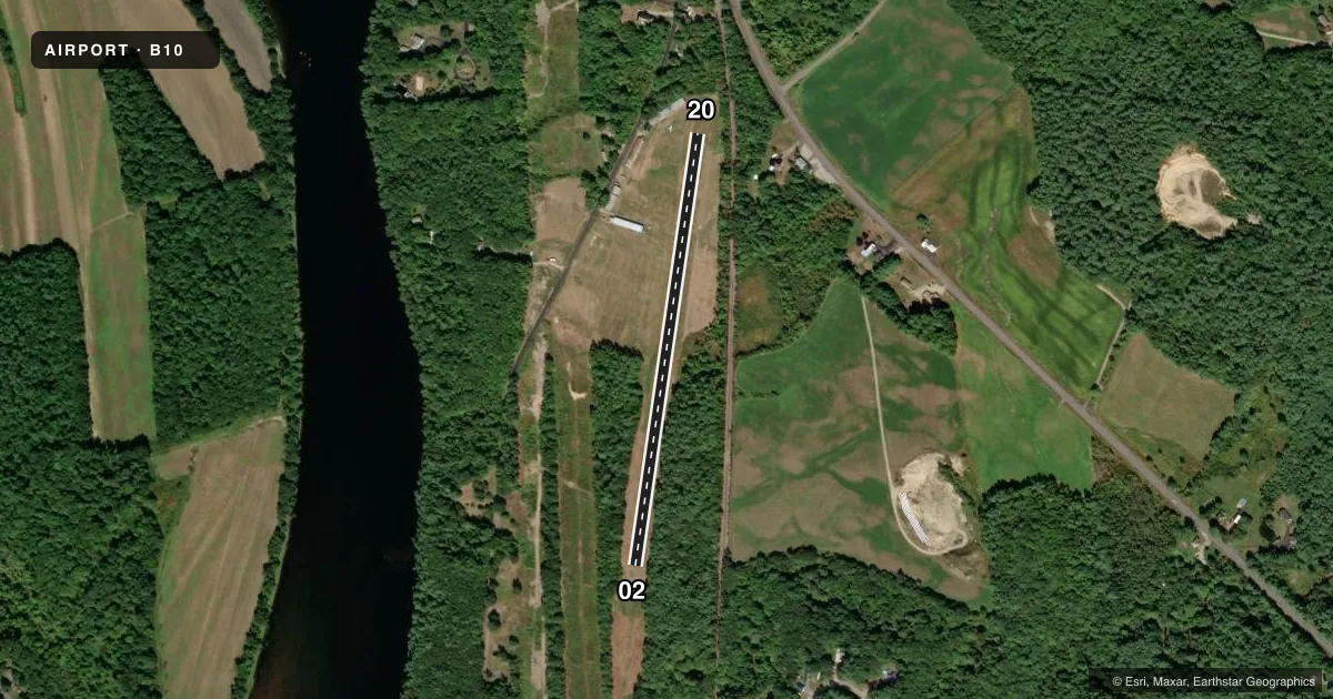
Airport sketch
Runways drawn to scale from FAA survey coordinates, rendered over satellite imagery. Not for navigation.
Approaches & charts
Services on the field
Fuel grades, oxygen, maintenance, ramp storage and lighting — as declared to the FAA by the airport operator.
Fuel & services
- Fuel
- Not available
Ramp & ground
- Transient storage
- Tie-down
- Landing fee
- No fee published
- Wind indicator
- Yes
- Segmented circle
- Yes
Fuel & FBOs
Cheapest 100LL and Jet A on the field and nearby. Always confirm with the FBO before taxi.
Airport notes
Surface conditions, obstructions, local procedures, lighting outages and other notes published with each FAA cycle.
General notes
- RWY NOT PLOWED IN WINTER; NO NGT OPS EXC IN EMERG.
- RWY 02/20 800 FT BY 160 FT CLEAR AREA BYD THR TO RWY 2 SW.
- RWY 2 40-70 FT TREES 800 FT FM THR, BOTH SIDES.
- RWY 02/20 190 FT BY 200 FT CLEAR AREA BYD THR TO THE NE.
- RWY 02/20 SOFT IN PLACES AFT RAIN, CALL AMGR FOR RWY CONDS.
- ARPT LCTD NEAR 14 LYMAN LN, LIVERMORE FALLS, ME.
- FOR CD CTC PORTLAND APCH AT 207-874-7320, WHEN APCH CLSD CTC BOSTON ARTCC AT 603-879-6859.
Approach & departure obstructions
- 02END MARKED WITH YELLOW BARRELS AT THR, WHITE 2 FT BY 2 FT MKRS ALG SIDE.
- 20END MARKED WITH YELLOW BARRELS AT THR, WHITE 2 FT BY 2 FT MKRS ALG SIDE.
Other notes
- THIS AIRPORT HAS BEEN SURVEYED BY THE NATIONAL GEODETIC SURVEY.
- VFR OPS ONLY.
- MANAGERALTN NR 207-320-0589.
VFR map & nearby airports
VFR sectional. Tap any ICAO chip to open that airport.
Key facts · B10
Answer card- ICAO
- B10
- Name
- BOWMAN FLD
- Location
- LIVERMORE FALLS, MAINE
- Elevation
- 324.2 ft MSL
- Traffic pattern altitude
- 1,674.2 ft MSL (1,350 AGL)
- Control tower
- Non-towered (use CTAF)
- Total runways
- 1
- Longest runway
- 02/20 · 2,201 ft
- Published ILS approaches
- 0
- Published frequencies
- 1
- Magnetic variation
- 18°
- Current flight rules
- VFR
- Current wind
- 000° at 0 kt
- Favored runway now
- –
Bowman Fld (B10) sits in Livermore Falls, Maine near 14 Lyman Lane. Field elevation is 324.2 ft MSL. The airport has one runway. Runway 02/20 is a 2,201 ft turf strip, so plan for soft spots after rain and check conditions with the airport manager before you go. The runway is not plowed in winter. Night operations are not permitted except in an emergency.
There is no control tower. CTAF is 122.9. No ILS approaches are published, so this is a VFR-only field. Pattern altitude is 1,350 ft AGL, which is 1,674.2 ft MSL. Runway 02 has yellow barrels at the threshold. Runway 20 has the same marking at its end. Published remarks also call out trees 40 to 70 ft high about 800 ft from the Runway 02 threshold on both sides. That is worth keeping in mind on departure and arrival.
No on-field FBOs are listed. For current fuel or service availability, contact the airport operator or call the field directly. If you need clearance delivery, the published remarks direct pilots to Portland Approach when it is open. When approach is closed, use Boston ARTCC. Runway headings are 8° for 02 and 188° for 20 magnetic.