METAR & TAF KWVL
Current METAR
Observed 16:56Z
KWVL 271656Z AUTO 00000KT 10SM CLR 26/12 A2980 RMK AO2 SLP094 T02560117
- Wind
- 000° @ 0 kt
- Visibility
- 10 SM
- Temp / Dew
- 26°C / 12°C
- Altimeter
- 29.80 inHg
- Clouds
- CLR
- Density alt
- 1,881 ft
- Ceiling
- Unlimited
- Rules
- VFR
Airport info & contacts
Manager on record, flight service, ARTCC, attendance schedule and pattern altitude — published by the FAA and refreshed every 28 days.
Location
- From city
- 2 NM SW
- VFR sectional
- MONTREAL
- ARTCC
- ZBW · BOSTON
- NOTAM facility
- WVL (NOTAM-D)
Airport manager
- Name
- RANDY MARSHALL JR
- Phone
- 207-861-8013
- Address
- 2 LAFLUER RD, WATERVILLE ME 04901
Flight service · Hours
- FSS BGR
- BANGOR1-800-WX-BRIEF
- Attendance
- MAY-OCT · 0900-1700
- NOV-APR · 0800-1600
Frequencies
Tap any row to copy the frequency to your clipboard.
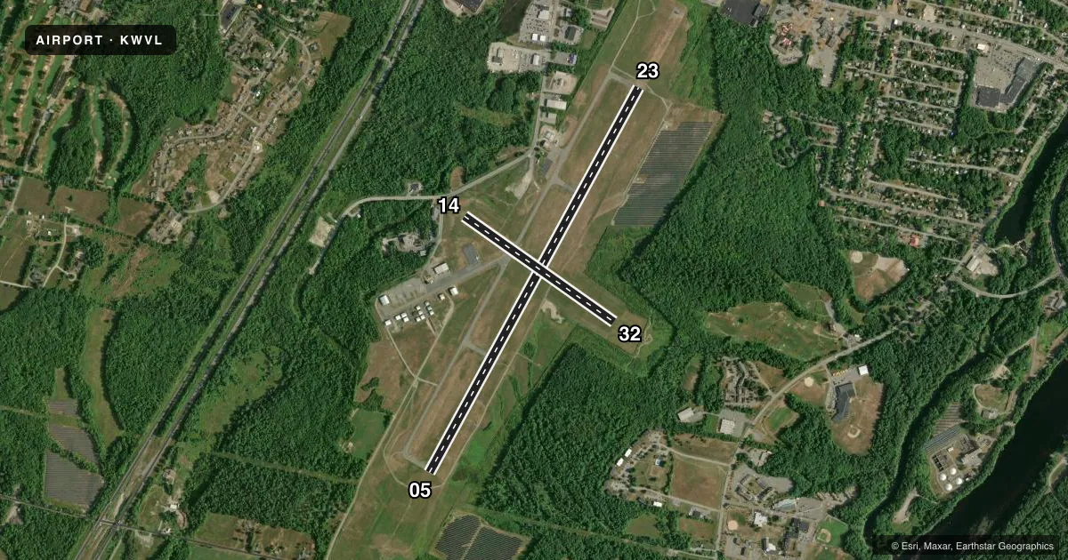
Runways & pattern
Full pagePattern entry · RWY 05
LEFT TRAFFIC| Runway | Heading (°M) | Length | Surface | Traffic |
|---|---|---|---|---|
| 05/23 | 11° / 191° | 5,500 ft | ASPH | Standard L |
| 14/32 | 107° / 287° | 2,301 ft | ASPH | Standard L |
Runway end performance
| End | TORA | TODA | ASDA | LDA | VGSI | Approach lights | Obstruction |
|---|---|---|---|---|---|---|---|
| 05 | — | — | — | — | VASI 4-box left(3°) | MALSF | — |
| 23 | — | — | — | — | PAPI 4-box left(3°) | — | — |
| 14 | — | — | — | — | — | — | 15', trees, 402' from thr, 50' R of cntrln, slope 13 |
Declared distances in feet. TORA = takeoff run available, TODA = takeoff distance, ASDA = accelerate-stop, LDA = landing distance.
Airport sketch
Runways drawn to scale from FAA survey coordinates, rendered over satellite imagery. Not for navigation.
Approaches & charts
ILS · 1
Services on the field
Fuel grades, oxygen, maintenance, ramp storage and lighting — as declared to the FAA by the airport operator.
Fuel & services
- Fuel
- 100LLA+
- Oxygen (bottled)
- Not available
- Oxygen (bulk)
- Not available
- Airframe repair
- Not available
- Power plant repair
- Not available
- Other services
- INSTR,PAJA,RNTL
Ramp & ground
- Transient storage
- Tie-down
- Hangar
- Landing fee
- No fee published
- Customs
- Not available
- Lighting schedule
- SEE RMK
- Beacon schedule
- SS-SR
- Beacon
- White / Green (civil land)(WG)
- Wind indicator
- Lighted
- Segmented circle
- Yes
Fuel & FBOs
Cheapest 100LL and Jet A on the field and nearby. Always confirm with the FBO before taxi.
Airport notes
Surface conditions, obstructions, local procedures, lighting outages and other notes published with each FAA cycle.
General notes
- ACFT OPS ON PAVED AREA ONLY.
- AVOID HOSPITAL 1 MI NORTH.
- ACFT DE-ICING AVBL.
- FOR CD WHEN APCH CLSD CTC BOSTON ARTCC AT 603-879-6859.
Lighting notes
- ACTVT MALSF RWY 05; REIL RWY 23; HIRL RWY 05/23 - CTAF.
Fuel notes
- 100LL24 HR SELF SERVE.
- A+FOR FUEL AFT HRS EMAIL AIRPORT@WATERVILLE-ME.GOV.
Other notes
- THIS AIRPORT HAS BEEN SURVEYED BY THE NATIONAL GEODETIC SURVEY.
- EXISTED PRIOR TO 1959.
- CALL AHD FOR AVBL.
- MANAGEREMAIL: RMARSHALL@WATERVILLE-ME.GOV.
VFR map & nearby airports
VFR sectional. Tap any ICAO chip to open that airport.
Key facts · KWVL
Answer card- ICAO
- KWVL
- Name
- WATERVILLE RGNL
- Location
- WATERVILLE, MAINE
- Elevation
- 332.8 ft MSL
- Traffic pattern altitude
- 1,332.8 ft MSL (1,000 AGL)
- Control tower
- Non-towered (use CTAF)
- Total runways
- 2
- Longest runway
- 05/23 · 5,500 ft
- Published ILS approaches
- 1
- Published frequencies
- 6
- Magnetic variation
- 18°
- Current flight rules
- VFR
- Current wind
- 000° at 0 kt
- Favored runway now
- –
Waterville Rgnl is in Waterville, Maine. The field elevation is 332.8 ft MSL. It has 2 asphalt runways. The longest is runway 05/23 at 5,500 ft. There is no control tower, so expect CTAF self-announce work on 122.7.
Runway 05 has the published ILS. MALSR lighting is on runway 05. Runway 23 has REIL lighting. High intensity runway lighting is available on 05 and 23 on CTAF. Pattern altitude is not published, so use the standard 1,000 ft AGL unless the current FAA Chart Supplement says otherwise. That puts the light aircraft pattern at about 1,333 ft MSL based on the field elevation.
Waterville LaFleur Airport is the on-field FBO. It carries 100LL, Jet A and Jet A Prist. 100LL is available 24 hours self-serve. The field also has de-icing available. One operational note matters here. Aircraft operations are permitted on paved areas only. Another note says to avoid the hospital one mile north. If you need transient hangar space, call ahead. If you need clearance delivery when approach is closed, contact Boston ARTCC. For a first visit, pay attention to the runway lighting setup and the non-towered traffic flow. The airport has two runways. 05/23 is the one that gives you the longest landing distance.