METAR & TAF 9B7
9B7 does not publish a METAR.
Showing the nearest reporting station: KBGR (BANGOR INTL) · 18.5 NM away. Conditions at 9B7 may differ.
METAR · KBGR
Observed 02:53Z
KBGR 270253Z 00000KT 10SM FEW080 13/11 A2988 RMK AO2 SLP115 T01330106 50004 $
- Wind
- 000° @ 0 kt
- Visibility
- 10 SM
- Temp / Dew
- 13°C / 11°C
- Altimeter
- 29.88 inHg
- Clouds
- FEW
- Density alt
- 58 ft
- Ceiling
- Unlimited
- Rules
- VFR
Airport info & contacts
Manager on record, flight service, ARTCC, attendance schedule and pattern altitude — published by the FAA and refreshed every 28 days.
Location
- From city
- 2 NM NE
- VFR sectional
- MONTREAL
- ARTCC
- ZBW · BOSTON
- NOTAM facility
- BGR (NOTAM-D)
Airport manager
- Name
- CALEB CURTIS
- Phone
- 207-487-5213
- Address
- 176 HARRISON ST, PITTSFIELD ME 04967-4570
Flight service · Hours
- FSS BGR
- BANGOR1-800-WX-BRIEF
- Attendance
- Unattended
Frequencies
Tap any row to copy the frequency to your clipboard.
Runways & pattern
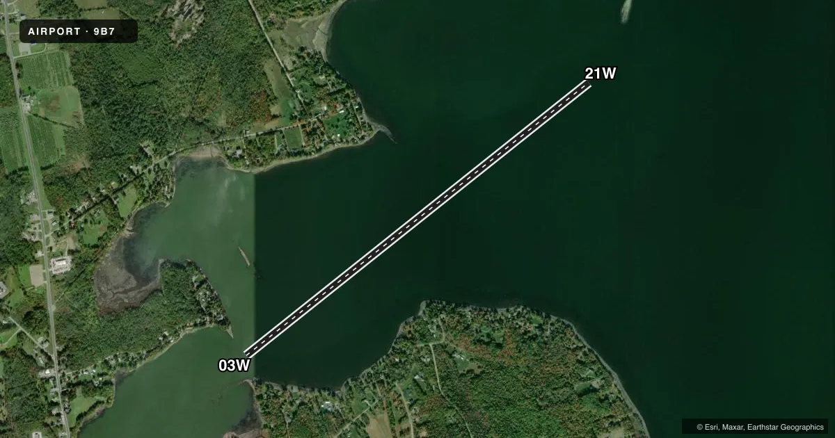
Full pagePattern entry · RWY 03W
LEFT TRAFFICAirport sketch
Runways drawn to scale from FAA survey coordinates, rendered over satellite imagery. Not for navigation.
Approaches & charts
Services on the field
Fuel grades, oxygen, maintenance, ramp storage and lighting — as declared to the FAA by the airport operator.
Fuel & services
- Fuel
- Not available
Ramp & ground
- Transient storage
- Not published
Fuel & FBOs
Cheapest 100LL and Jet A on the field and nearby. Always confirm with the FBO before taxi.
Airport notes
Surface conditions, obstructions, local procedures, lighting outages and other notes published with each FAA cycle.
General notes
- FOR CD CTC BANGOR APCH AT 207-561-2500 EXTN 1.
VFR map & nearby airports
VFR sectional. Tap any ICAO chip to open that airport.
Key facts · 9B7
Answer card- ICAO
- 9B7
- Name
- HAMLIN'S MARINA & SPB
- Location
- NEWPORT, MAINE
- Elevation
- 200 ft MSL
- Traffic pattern altitude
- 1,200 ft MSL (1,000 AGL)
- Control tower
- Non-towered (use CTAF)
- Total runways
- 1
- Longest runway
- 03W/21W · 6,996 ft
- Published ILS approaches
- 0
- Published frequencies
- 1
- Magnetic variation
- –
- Current flight rules
- VFR
- Current wind
- 000° at 0 kt
- Favored runway now
- –
Hamlin's Marina & SPB (9B7) sits in Newport, Maine. Field elevation is 200 ft MSL. The airport has one runway. It is a 6,996 ft water runway, designated 03W/21W with magnetic headings of 45° and 225°. There is no control tower. CTAF is 122.9.
No ILS approaches are published here. Pattern altitude is not published, so use the standard 1,000 ft AGL for light piston operations unless the current Chart Supplement says otherwise. For clearance delivery, the published remark says to contact Bangor Approach at 207-561-2500 extension 1. That is the item to have ready before departure if you need IFR handling.
There are no on-field FBOs listed in the facts. Plan on checking with the airport operator or the FBO directly by phone before arrival if you need services. The field is a seaplane base, so water operations are the main consideration. Verify current local procedures. Verify traffic flow. Verify any seasonal limitations before you go. The published data here is sparse. The current FAA Chart Supplement is the place to confirm anything operational that is not listed.