METAR & TAF 1B0
1B0 does not publish a METAR.
Showing the nearest reporting station: KBGR (BANGOR INTL) · 21.0 NM away. Conditions at 1B0 may differ.
METAR · KBGR
Observed 12:53Z
KBGR 271253Z 00000KT 10SM CLR 21/12 A2986 RMK AO2 SLP109 T02060117
- Wind
- 000° @ 0 kt
- Visibility
- 10 SM
- Temp / Dew
- 21°C / 12°C
- Altimeter
- 29.86 inHg
- Clouds
- CLR
- Density alt
- 1,456 ft
- Ceiling
- Unlimited
- Rules
- VFR
Airport info & contacts
Manager on record, flight service, ARTCC, attendance schedule and pattern altitude — published by the FAA and refreshed every 28 days.
Location
- From city
- 3 NM E
- VFR sectional
- MONTREAL
- ARTCC
- ZBW · BOSTON
- NOTAM facility
- BGR (NOTAM-D)
Airport manager
- Name
- ROGER NELSON
- Phone
- 207-270-0239
- Address
- 129 OLD BANGOR RD, NEWPORT ME 04953
Flight service · Hours
- FSS BGR
- BANGOR1-800-WX-BRIEF
- Attendance
- Unattended
Frequencies
Tap any row to copy the frequency to your clipboard.
Runways & pattern
Full pagePattern entry · RWY 16
LEFT TRAFFICAirport sketch
Runways drawn to scale from FAA survey coordinates, rendered over satellite imagery. Not for navigation.
Approaches & charts
Services on the field
Fuel grades, oxygen, maintenance, ramp storage and lighting — as declared to the FAA by the airport operator.
Fuel & services
- Fuel
- 100LLMOGAS
- Oxygen (bottled)
- Not available
- Oxygen (bulk)
- Not available
- Airframe repair
- Not available
- Power plant repair
- Not available
Ramp & ground
- Transient storage
- Tie-down
- Landing fee
- No fee published
- Customs
- Not available
- Lighting schedule
- SEE RMK
- Beacon schedule
- SS-SR
- Beacon
- White / Green (civil land)(WG)
- Wind indicator
- Lighted
- Segmented circle
- Yes
Fuel & FBOs
Cheapest 100LL and Jet A on the field and nearby. Always confirm with the FBO before taxi.
Airport notes
Surface conditions, obstructions, local procedures, lighting outages and other notes published with each FAA cycle.
General notes
- WILDLIFE ON OR INVOF ARPT.
- FOR CD CTC BANGOR APCH AT 207-561-2500 EXTN 1.
- TXL A CLSD TO ACFT WITH WINGSPAN GTR THAN 36 FT.
- TXL A RSTRD TO BASED ACFT ONLY.
Lighting notes
- ACTVT MIRL RWY 16/34 - CTAF.
Fuel notes
- 100LL24 HR FUEL WITH MAJOR CREDIT CARD, NO ETHANOL IN MOGAS.
Other notes
- EXISTED PRIOR TO 1959.
- BRING OWN TIE DOWNS.
VFR map & nearby airports
VFR sectional. Tap any ICAO chip to open that airport.
Key facts · 1B0
Answer card- ICAO
- 1B0
- Name
- DEXTER RGNL
- Location
- DEXTER, MAINE
- Elevation
- 533.3 ft MSL
- Traffic pattern altitude
- 1,533.3 ft MSL (1,000 AGL)
- Control tower
- Non-towered (use CTAF)
- Total runways
- 2
- Longest runway
- 16/34 · 3,008 ft
- Published ILS approaches
- 0
- Published frequencies
- 4
- Magnetic variation
- 18°
- Current flight rules
- VFR
- Current wind
- 000° at 0 kt
- Favored runway now
- –
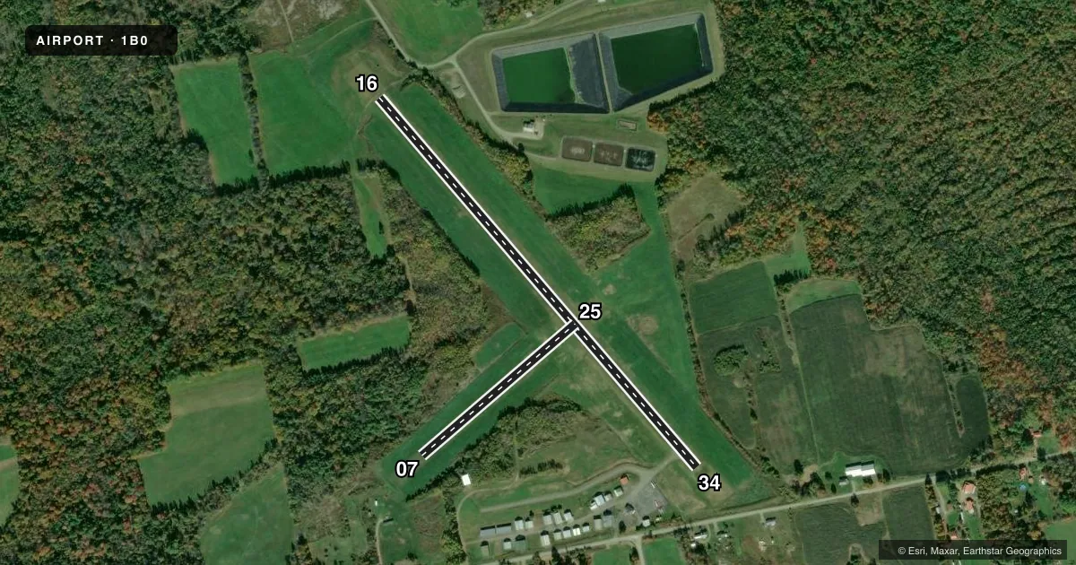
Dexter Regional Airport sits in Dexter, Maine at 533.3 ft MSL. It has two runways. The longest is runway 16/34 at 3,008 ft. Runway 07/25 is turf at 1,249 ft. There is no control tower. Use CTAF 122.8 for local traffic. Bangor Approach handles clearance delivery and approach or departure services. No ILS approaches are published here.
The published pattern altitude is not listed. For light piston operations, use the standard 1,000 ft AGL unless the current FAA Chart Supplement says otherwise. The field has one on-field FBO, Dexter Regional Airport. It carries 100LL and mogas. Fuel is available 24 hours with a major credit card. The published remarks also note wildlife on or near the airport. Taxiway A is restricted to based aircraft only. It is also closed to aircraft with a wingspan greater than 36 ft. Medium intensity runway lights for runway 16/34 are activated by CTAF. Bring your own tie downs.
For a first trip, pay attention to the turf runway, the wildlife and the lighting procedure. This is a non-towered field with Bangor handling IFR services, so have your clearance plan ready before departure. Check the current FAA Chart Supplement for any updated operating notes before you go.