METAR & TAF 0B2
0B2 does not publish a METAR.
Showing the nearest reporting station: KBGR (BANGOR INTL) · 3.7 NM away. Conditions at 0B2 may differ.
METAR · KBGR
Observed 12:53Z
KBGR 271253Z 00000KT 10SM CLR 21/12 A2986 RMK AO2 SLP109 T02060117
- Wind
- 000° @ 0 kt
- Visibility
- 10 SM
- Temp / Dew
- 21°C / 12°C
- Altimeter
- 29.86 inHg
- Clouds
- CLR
- Density alt
- 949 ft
- Ceiling
- Unlimited
- Rules
- VFR
Airport info & contacts
Manager on record, flight service, ARTCC, attendance schedule and pattern altitude — published by the FAA and refreshed every 28 days.
Location
- From city
- 2 NM S
- VFR sectional
- HALIFAX
- Pattern altitude
- 600 ft AGL · 725 ft MSL
- ARTCC
- ZBW · BOSTON
- NOTAM facility
- BGR (NOTAM-D)
Airport manager
- Name
- MICHAEL HIGGINS
- Phone
- 207-299-4086
- Address
- 49 AIRPORT RD, 14TH ST, BREWER ME 04412
Flight service · Hours
- FSS BGR
- BANGOR1-800-WX-BRIEF
- Attendance
- Unattended
Frequencies
Tap any row to copy the frequency to your clipboard.
Runways & pattern
Full pagePattern entry · RWY 01
RIGHT TRAFFICRunway end performance
| End | TORA | TODA | ASDA | LDA | VGSI | Approach lights | Obstruction |
|---|---|---|---|---|---|---|---|
| 01 | — | — | — | — | — | — | 25', brush, 0' from thr, 35' R of cntrln, slope 0 |
| 19 | — | — | — | — | — | — | 20', trees, 0' from thr, 30' R of cntrln, slope 0 |
Declared distances in feet. TORA = takeoff run available, TODA = takeoff distance, ASDA = accelerate-stop, LDA = landing distance.
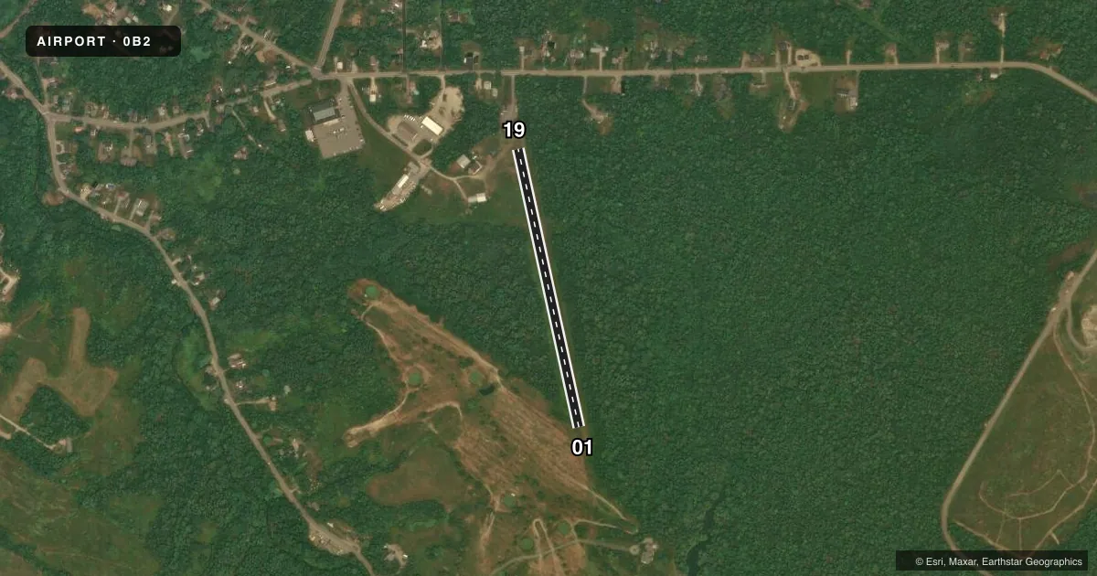
Airport sketch
Runways drawn to scale from FAA survey coordinates, rendered over satellite imagery. Not for navigation.
Approaches & charts
Services on the field
Fuel grades, oxygen, maintenance, ramp storage and lighting — as declared to the FAA by the airport operator.
Fuel & services
- Fuel
- Not available
- Oxygen (bottled)
- Not available
- Oxygen (bulk)
- Not available
- Airframe repair
- Minor
- Power plant repair
- Minor
Ramp & ground
- Transient storage
- Tie-down
- Hangar
- Landing fee
- No fee published
- Customs
- Not available
- Wind indicator
- Yes
- Segmented circle
- No
Fuel & FBOs
Cheapest 100LL and Jet A on the field and nearby. Always confirm with the FBO before taxi.
Airport notes
Surface conditions, obstructions, local procedures, lighting outages and other notes published with each FAA cycle.
General notes
- MAKE ALL APCH/DEPS TO E OF ARPT.
- +25 FT PWR LN 460 FT N OF RWY 19 END.
- PUBLIC GOLFCOURSE AT EOR 01.
- RWY 01/19 +35 FT TREES & BRUSH 30 FT TO 125 FT FM CNTRLN ALG E SIDE.
- WILDLIFE ON OR INVOF ARPT.
- DURG WINTER SKIS ONLY OPS.
- RWY 19 +25 FT HOUSE 80 FT FM THR, 50 FT R OF CNTRLN.
- FOR CD CTC BANGOR APCH AT 207-561-2500 EXTN 1.
- RWY 1-19 CNTR 50 FT MOWED.
Approach & departure obstructions
- 01CTLG OBSTN EXCEEDS A 45 DEG SLP.
Other notes
- EXISTED PRIOR TO 1959.
- CALL FOR AVBL.
VFR map & nearby airports
VFR sectional. Tap any ICAO chip to open that airport.
Key facts · 0B2
Answer card- ICAO
- 0B2
- Name
- BREWER
- Location
- BREWER, MAINE
- Elevation
- 124.5 ft MSL
- Traffic pattern altitude
- 724.5 ft MSL (600 AGL)
- Control tower
- Non-towered (use CTAF)
- Total runways
- 1
- Longest runway
- 01/19 · 1,730 ft
- Published ILS approaches
- 0
- Published frequencies
- 1
- Magnetic variation
- 19°
- Current flight rules
- VFR
- Current wind
- 000° at 0 kt
- Favored runway now
- –
Brewer Airport (0B2) sits in Brewer, Maine. The field elevation is 124.5 ft MSL. It has one runway, 01/19, which is 1,730 ft of turf. The airport is non-towered. CTAF is 122.9. No ILS approaches are published here. Pattern altitude is 600 ft AGL, which is 724.5 ft MSL.
This is a short turf strip with some real constraints. The published remarks say to make all approaches and departures east of the airport. There is a public golf course at the east end of runway 01. A cataloged obstruction exceeds a 45 degree slope at runway 01. There are also 35 ft trees and brush along the east side of the runway. At runway 19, a 25 ft house sits 80 ft from the threshold and 50 ft right of centerline. A 25 ft power line is 460 ft north of the runway 19 end. Wildlife is reported on or near the airport.
There are no on-field FBOs listed. Call for availability before you go. For clearance delivery, Bangor Approach is listed at 207-561-2500 extension 1. In winter, the field is for ski operations only. First-time pilots should plan carefully for the turf surface. They should also plan for the short runway length and the east-side obstructions.