METAR & TAF KBHB
Current METAR
Observed 12:56Z
KBHB 271256Z AUTO 08003KT 10SM CLR 19/09 A2986 RMK AO2 SLP113 T01940094 $
- Wind
- 080° @ 3 kt
- Visibility
- 10 SM
- Temp / Dew
- 19°C / 9°C
- Altimeter
- 29.86 inHg
- Clouds
- CLR
- Density alt
- 658 ft
- Ceiling
- Unlimited
- Rules
- VFR
Airport info & contacts
Manager on record, flight service, ARTCC, attendance schedule and pattern altitude — published by the FAA and refreshed every 28 days.
Location
- From city
- 8 NM NW
- VFR sectional
- HALIFAX
- ARTCC
- ZBW · BOSTON
- NOTAM facility
- BHB (NOTAM-D)
Airport manager
- Name
- LEROY MUISE
- Phone
- 207-667-7329
- Address
- 115 CARUSO DR, TRENTON ME 04605
Flight service · Hours
- FSS BGR
- BANGOR1-800-WX-BRIEF
- Attendance
- 0800-1800
Frequencies
Tap any row to copy the frequency to your clipboard.
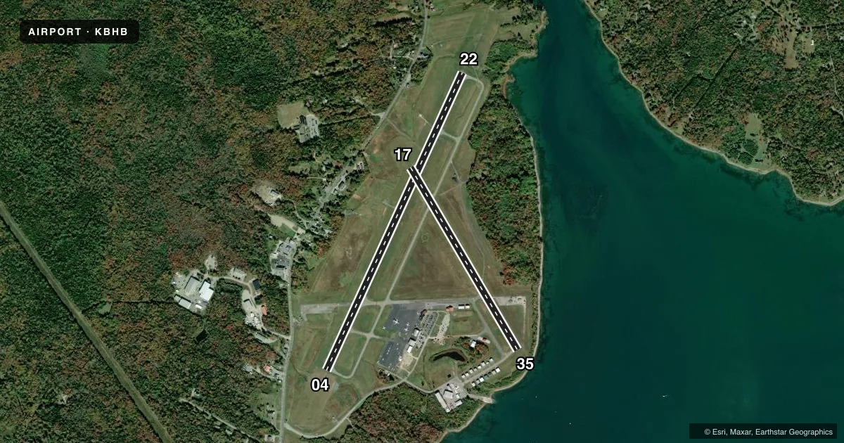
Runways & pattern
Full pagePattern entry · RWY 04
LEFT TRAFFIC| Runway | Heading (°M) | Length | Surface | Traffic |
|---|---|---|---|---|
| 04/22Favored | 6° / 186° | 5,200 ft | ASPH | Standard L |
| 17/35 | 131° / 311° | 3,363 ft | ASPH | Standard L |
Runway end performance
| End | TORA | TODA | ASDA | LDA | VGSI | Approach lights | Obstruction |
|---|---|---|---|---|---|---|---|
| 04 | 5,200' | 5,200' | 5,200' | 5,200' | VASI 4-box left(3°) | — | 125', trees, 1410' from thr, 500' R of cntrln, slope 9 |
| 22 | 5,200' | 5,200' | 5,200' | 5,200' | VASI 4-box left(3°) | MALSF | — |
| 17 | — | — | — | — | — | — | 148', tree, 900' from thr, 60' R of cntrln, slope 5 |
Declared distances in feet. TORA = takeoff run available, TODA = takeoff distance, ASDA = accelerate-stop, LDA = landing distance.
Airport sketch
Runways drawn to scale from FAA survey coordinates, rendered over satellite imagery. Not for navigation.
Approaches & charts
ILS · 1
Services on the field
Fuel grades, oxygen, maintenance, ramp storage and lighting — as declared to the FAA by the airport operator.
Fuel & services
- Fuel
- 100LLA
- Oxygen (bottled)
- Not available
- Oxygen (bulk)
- Not available
- Airframe repair
- Minor
- Power plant repair
- Minor
- Other services
- INSTR,RNTL
Ramp & ground
- Transient storage
- Tie-down
- Hangar
- Landing fee
- Yes
- Customs
- Not available
- Lighting schedule
- SEE RMK
- Beacon schedule
- SS-SR
- Beacon
- White / Green (civil land)(WG)
- Wind indicator
- Yes
- Segmented circle
- Yes
Fuel & FBOs
Cheapest 100LL and Jet A on the field and nearby. Always confirm with the FBO before taxi.
Airport notes
Surface conditions, obstructions, local procedures, lighting outages and other notes published with each FAA cycle.
General notes
- BIRDS ON & INVOF ARPT.
- DURG VFR CONDS WHEN WIND SPEED LESS THAN 5 KTS AS RPRTD BY AWOS OR UNICOM, ALL ACFT USING RWY 04/22 ARE REQD TO TKOF & LAND ON RWY 22 FOR NOISE ABATEMENT PROCS.
- TWY BRAVO CLSD TO ALL ACFT GTR THAN 10000 LBS.
- PPR FOR OVERWEIGHT LDGS. PPR FOR UNSKED ACR OPS RQRG 14 CFR 139 ARFF. CTC AMGR.
- TWYS F & G CLSD DEC 1- MAR 31 ANNUALLY.
- SEAPLANE RAMP UNAVBL FOR ACFT OPS EXC PPR 207-667-7329.
- FICON NOT MNT MON-FRI 2100-0730, WKENDS & HOLS.
- IF CD FREQ UNAVBL CTC BANGOR APCH AT 207-561-2500 EXTN 1.
- GRASS AREAS UNAVBL FOR ACFT OPS.
- 48 HR PPR FOR UNSKED ACR OPS AT LEAST 31 PAX SEATS. CTC AMGR.
Lighting notes
- ACTVT MALSF RWY 22; REIL RWY 04; VASI RWY 04 & 22; HIRL RWY 04/22 - 122.7.
Runway surface & condition
- 04/22PCR VALUE: 350/F/D/X/T
- 17/35PCR VALUE: 40/F/D/Y/U
- 04/22DUE TO HUMP AT MIDPT, OPPOSITE ENDS OF RWY NOT VSB AT GND LEVEL.
- 17/35RWY 17/35 NOT AVBL FOR PART 121/PART 380 OPS WITH SKED PAX CARRYING OPS MORE THAN 9 PAX SEATS AND NON-SKED PAX CARRYING OPS MORE THAN 30 PAX SEATS. NO PART 121/PART 380 OPS EXC FOR TAX ON RWY 17/35 BTN 04/22 AND TWY H.
Approach & departure obstructions
- 1710:1 TO DTHR.
Other notes
- EXISTED PRIOR TO 1959.
VFR map & nearby airports
VFR sectional. Tap any ICAO chip to open that airport.
Key facts · KBHB
Answer card- ICAO
- KBHB
- Name
- HANCOCK COUNTY/BAR HARBOR
- Location
- BAR HARBOR, MAINE
- Elevation
- 83.2 ft MSL
- Traffic pattern altitude
- 1,083.2 ft MSL (1,000 AGL)
- Control tower
- Non-towered (use CTAF)
- Total runways
- 2
- Longest runway
- 04/22 · 5,200 ft
- Published ILS approaches
- 1
- Published frequencies
- 5
- Magnetic variation
- 19°
- Current flight rules
- VFR
- Current wind
- 080° at 3 kt
- Favored runway now
- RWY 04
Hancock County/Bar Harbor Airport sits in Bar Harbor, Maine. Field elevation is 83.2 ft MSL. The airport has two asphalt runways. The longest is runway 04/22 at 5,200 ft. There is no control tower, so use CTAF 123.0 and UNICOM 123.0 for local traffic. The published pattern altitude is not listed, so plan on the standard 1,000 ft AGL unless the current FAA Chart Supplement says otherwise.
KBHB has one ILS approach to runway 22. Runway 22 also has medium intensity approach lighting with sequenced flashers. Runway 04 has REILs. Both 04 and 22 have a VASI. The field is served by Modern Aviation on the field. They carry 100LL, Jet A and Jet A Prist. The airport sits in a coastal area, so expect changing wind and bird activity in the vicinity. The published remarks also say that when VFR winds are under 5 knots as reported by AWOS or UNICOM, aircraft using runway 04/22 are required to use runway 22 for noise abatement. Runway 04/22 has a hump at midpoint. The opposite ends are not visible from ground level. Taxiways F and G are closed each year from December 1 through March 31. Check the current FAA Chart Supplement for any current restrictions before you go.