METAR & TAF 43B
43B does not publish a METAR.
Showing the nearest reporting station: KBHB (HANCOCK COUNTY/BAR HARBOR) · 23.0 NM away. Conditions at 43B may differ.
METAR · KBHB
Observed 18:56Z
KBHB 271856Z AUTO 20010KT 10SM CLR 24/12 A2979 RMK AO2 SLP091 T02440122 $
- Wind
- 200° @ 10 kt
- Visibility
- 10 SM
- Temp / Dew
- 24°C / 12°C
- Altimeter
- 29.79 inHg
- Clouds
- CLR
- Density alt
- 1,511 ft
- Ceiling
- Unlimited
- Rules
- VFR
Airport info & contacts
Manager on record, flight service, ARTCC, attendance schedule and pattern altitude — published by the FAA and refreshed every 28 days.
Location
- From city
- 2 NM SE
- VFR sectional
- HALIFAX
- ARTCC
- ZBW · BOSTON
- NOTAM facility
- BGR (NOTAM-D)
Airport manager
- Name
- JOE LACERDA
- Phone
- 207-941-4502
- Address
- MAINE DEPT OF TRANSPORTATION, 219 HOGAN RD, BANGOR ME 04401
Flight service · Hours
- FSS BGR
- BANGOR1-800-WX-BRIEF
- Attendance
- Unattended
Frequencies
Tap any row to copy the frequency to your clipboard.
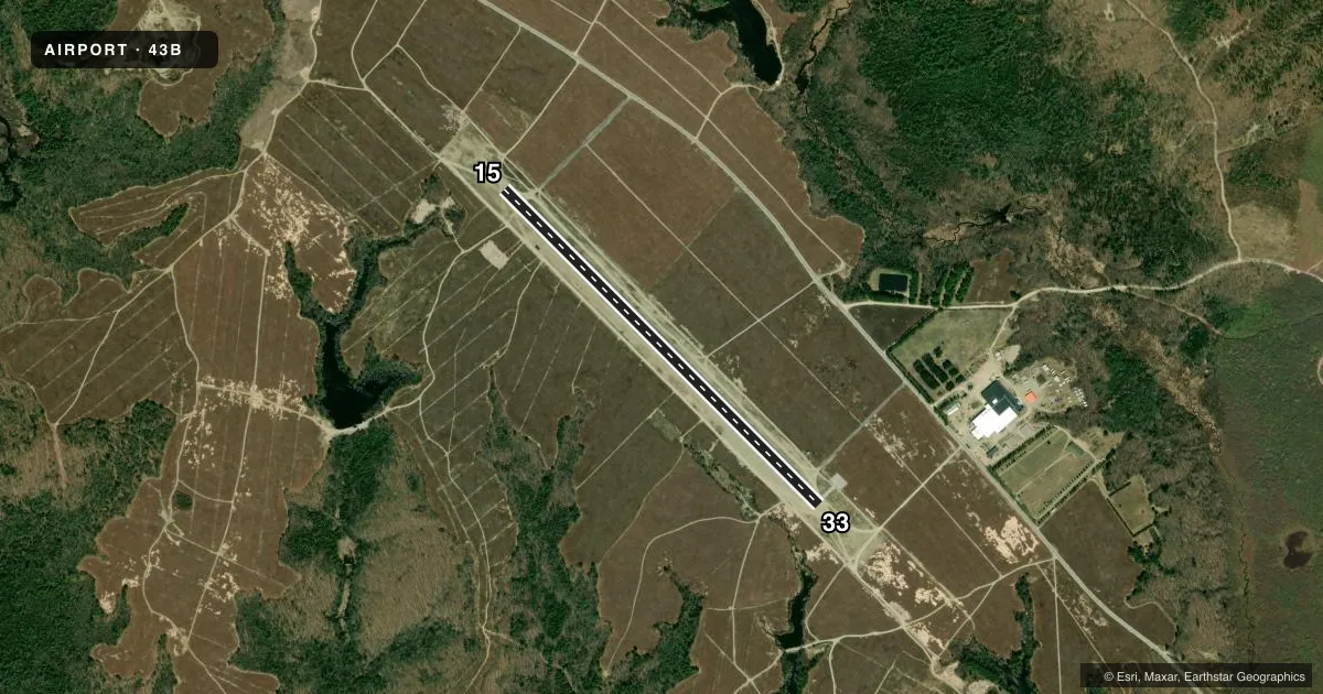
Runways & pattern
Full pagePattern entry · RWY 15
LEFT TRAFFICAirport sketch
Runways drawn to scale from FAA survey coordinates, rendered over satellite imagery. Not for navigation.
Approaches & charts
Services on the field
Fuel grades, oxygen, maintenance, ramp storage and lighting — as declared to the FAA by the airport operator.
Fuel & services
- Fuel
- Not available
- Oxygen (bottled)
- Not available
- Oxygen (bulk)
- Not available
- Airframe repair
- Not available
- Power plant repair
- Not available
Ramp & ground
- Transient storage
- Not published
- Landing fee
- No fee published
- Customs
- Not available
- Wind indicator
- Yes
- Segmented circle
- Yes
Fuel & FBOs
Cheapest 100LL and Jet A on the field and nearby. Always confirm with the FBO before taxi.
Airport notes
Surface conditions, obstructions, local procedures, lighting outages and other notes published with each FAA cycle.
General notes
- CLSD WINTER MONTHS EXCEPT TO SKI ACFT.
- DAYLIGHT USE ONLY.
- RWY COULD HAVE LOOSE GRVL TRKD ONTO SFC BY VEHICULAR TFC. MEN & EQUIP COULD BE NEAR OR ON RWY SFC DURG SUMMER MONTHS.
- PAVEMENT DROP-OFFS AT THLDS OF RWY 15 & RWY 33 IN EXCESS OF 5 IN.
- FOR CD CTC BOSTON ARTCC AT 603-879-6859.
Approach & departure obstructions
- 15NRS AND CNTRLN FADED OR MISG.
- 33NRS AND CNTRLN FADED OR MISG.
Other notes
- EXISTED PRIOR TO 1959.
- OWNERMAINE DEPT OF TRANSPORTATION.
VFR map & nearby airports
VFR sectional. Tap any ICAO chip to open that airport.
Key facts · 43B
Answer card- ICAO
- 43B
- Name
- DEBLOIS FLIGHT STRIP
- Location
- DEBLOIS, MAINE
- Elevation
- 217.7 ft MSL
- Traffic pattern altitude
- 1,217.7 ft MSL (1,000 AGL)
- Control tower
- Non-towered (use CTAF)
- Total runways
- 1
- Longest runway
- 15/33 · 4,500 ft
- Published ILS approaches
- 0
- Published frequencies
- 1
- Magnetic variation
- 16°
- Current flight rules
- VFR
- Current wind
- 200° at 10 kt
- Favored runway now
- RWY 15
DeBlois Flight Strip (43B) sits in Deblois, Maine. Field elevation is 217.7 ft MSL. The airport has one runway, 15/33, at 4,500 ft of asphalt. There is no control tower. CTAF is 122.9. No ILS approaches are published here.
The pattern altitude is not published. Use the standard 1,000 ft AGL pattern for light piston operations unless the current FAA Chart Supplement says otherwise. That puts the pattern at about 1,218 ft MSL based on the field elevation. Confirm before you go if you are flying anything unusual.
There are no on-field FBOs listed. Plan on self-sufficiency and verify current services with the airport operator or by calling the field on CTAF before arrival. Published remarks matter here. The runway can pick up loose gravel from vehicle traffic. Men and equipment may be on or near the runway in summer. Runway numbers and centerlines are faded or missing on both ends. Threshold drop-offs on 15 and 33 are reported to be more than 5 inches. The field is daylight use only. It is closed in winter months except for ski aircraft. For clearance delivery, contact Boston ARTCC at 603-879-6859.