METAR & TAF KMVM
KMVM does not publish a METAR.
Showing the nearest reporting station: KBHB (HANCOCK COUNTY/BAR HARBOR) · 40.7 NM away. Conditions at KMVM may differ.
METAR · KBHB
Observed 14:56Z
KBHB 271456Z AUTO 12004KT 10SM CLR 23/12 A2984 RMK AO2 SLP105 T02330122 58007 $
- Wind
- 120° @ 4 kt
- Visibility
- 10 SM
- Temp / Dew
- 23°C / 12°C
- Altimeter
- 29.84 inHg
- Clouds
- CLR
- Density alt
- 1,178 ft
- Ceiling
- Unlimited
- Rules
- VFR
Airport info & contacts
Manager on record, flight service, ARTCC, attendance schedule and pattern altitude — published by the FAA and refreshed every 28 days.
Location
- From city
- 1 NM SW
- VFR sectional
- HALIFAX
- ARTCC
- ZBW · BOSTON
- NOTAM facility
- BGR (NOTAM-D)
Airport manager
- Name
- BILL KITCHEN
- Phone
- 207-271-0808
- Address
- TOWN OFFICES, PO BOX 418, MACHIAS ME 04654
Flight service · Hours
- FSS BGR
- BANGOR1-800-WX-BRIEF
- Attendance
- Unattended
Frequencies
Tap any row to copy the frequency to your clipboard.
Runways & pattern
Full pagePattern entry · RWY 18
LEFT TRAFFICRunway end performance
| End | TORA | TODA | ASDA | LDA | VGSI | Approach lights | Obstruction |
|---|---|---|---|---|---|---|---|
| 36 | — | — | — | — | — | — | 53', pole, 999' from thr, 339' R of cntrln, slope 15 |
Declared distances in feet. TORA = takeoff run available, TODA = takeoff distance, ASDA = accelerate-stop, LDA = landing distance.
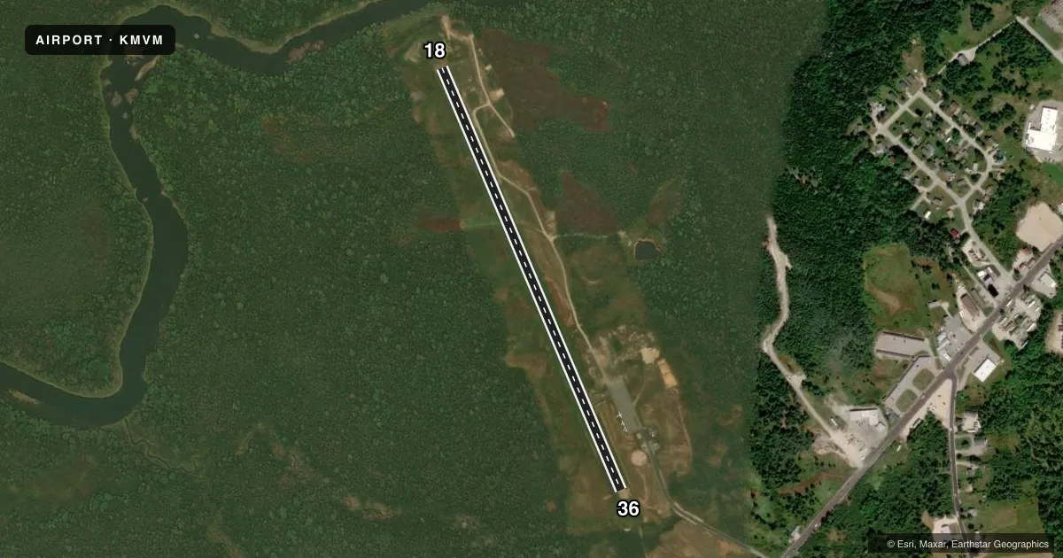
Airport sketch
Runways drawn to scale from FAA survey coordinates, rendered over satellite imagery. Not for navigation.
Approaches & charts
Services on the field
Fuel grades, oxygen, maintenance, ramp storage and lighting — as declared to the FAA by the airport operator.
Fuel & services
- Fuel
- 100LL
- Oxygen (bottled)
- Not available
- Oxygen (bulk)
- Not available
- Airframe repair
- Not available
- Power plant repair
- Not available
Ramp & ground
- Transient storage
- Tie-down
- Landing fee
- No fee published
- Customs
- Not available
- Lighting schedule
- SEE RMK
- Beacon schedule
- SS-SR
- Beacon
- White / Green (civil land)(WG)
- Wind indicator
- Lighted
- Segmented circle
- Yes
Fuel & FBOs
Cheapest 100LL and Jet A on the field and nearby. Always confirm with the FBO before taxi.
Airport notes
Surface conditions, obstructions, local procedures, lighting outages and other notes published with each FAA cycle.
General notes
- DEER & WILDLIFE ON & INVOF ARPT.
- FOR CD CTC BOSTON ARTCC AT 603-879-6859.
Lighting notes
- ACTVT REIL RWY 36; MIRL RWY 18/36 - CTAF.
Fuel notes
- 100LL24 HR SELF SVC WITH MAJOR CREDIT CARD.
Other notes
- MANAGERTOWN MGR EMAIL: TOWNMANAGER@MACHIASME.ORG.
VFR map & nearby airports
VFR sectional. Tap any ICAO chip to open that airport.
Key facts · KMVM
Answer card- ICAO
- KMVM
- Name
- MACHIAS VALLEY
- Location
- MACHIAS, MAINE
- Elevation
- 96.2 ft MSL
- Traffic pattern altitude
- 1,096.2 ft MSL (1,000 AGL)
- Control tower
- Non-towered (use CTAF)
- Total runways
- 1
- Longest runway
- 18/36 · 2,880 ft
- Published ILS approaches
- 0
- Published frequencies
- 2
- Magnetic variation
- 19°
- Current flight rules
- VFR
- Current wind
- 120° at 4 kt
- Favored runway now
- RWY 18
Machias Valley Airport sits in Machias, Maine. Field elevation is 96.2 ft MSL. The airport has one runway, 18/36 and it is 2,880 ft long on asphalt. There is no control tower. CTAF and UNICOM are both 122.8. No ILS approaches are published here.
Pattern altitude is not published. Use 1,000 ft AGL for light piston operations unless the current Chart Supplement says otherwise. Runway 36 has REIL lighting. Medium intensity runway lighting is available on runways 18 and 36. It is controlled by the CTAF. 24-hour self-service 100LL is available with major credit cards. There are no on-field FBOs listed.
For a first visit, plan for an uncontrolled field with local traffic on 122.8. Deer and wildlife are reported on and near the airport, so keep a sharp scan on taxi, takeoff and landing. If you need IFR clearance, contact Boston ARTCC at 603-879-6859. The runway is short by transport standards, so check performance carefully before you go. The field is in coastal Maine. Expect to treat weather and wind shifts with the same caution you would use at any small non-towered airport.