METAR & TAF KEPM
KEPM does not publish a METAR.
Showing the nearest reporting station: CYSJ (ST JOHN) · 53.4 NM away. Conditions at KEPM may differ.
METAR · CYSJ
Observed 19:00Z
CYSJ 271900Z 12007G15KT 15SM FEW050 FEW270 27/14 A2977 RMK CF1CI1 SLP084 DENSITY ALT 2000FT
- Wind
- 120° @ 7G15 kt
- Visibility
- 15 SM
- Temp / Dew
- 27°C / 14°C
- Altimeter
- 29.77 inHg
- Clouds
- FEW
- Density alt
- 1,682 ft
- Ceiling
- Unlimited
- Rules
- VFR
Airport info & contacts
Manager on record, flight service, ARTCC, attendance schedule and pattern altitude — published by the FAA and refreshed every 28 days.
Location
- From city
- 1 NM W
- VFR sectional
- HALIFAX
- ARTCC
- ZBW · BOSTON
- NOTAM facility
- EPM (NOTAM-D)
Airport manager
- Name
- VICTORIA GANZ
- Phone
- 207-214-4751
- Address
- 1 AIRPORT WAY, EASTPORT ME 04631
Flight service · Hours
- FSS BGR
- BANGOR1-800-WX-BRIEF
- Attendance
- ON CALL
Frequencies
Tap any row to copy the frequency to your clipboard.
Runways & pattern
Full pagePattern entry · RWY 14
LEFT TRAFFICRunway end performance
| End | TORA | TODA | ASDA | LDA | VGSI | Approach lights | Obstruction |
|---|---|---|---|---|---|---|---|
| 14 | — | — | — | — | PAPI 2-box left(3.1°) | — | 12', tree, 205' from thr, 75' R of cntrln, slope 0 |
| 32 | — | — | — | — | PAPI 2-box left(3.28°) | — | — |
Declared distances in feet. TORA = takeoff run available, TODA = takeoff distance, ASDA = accelerate-stop, LDA = landing distance.
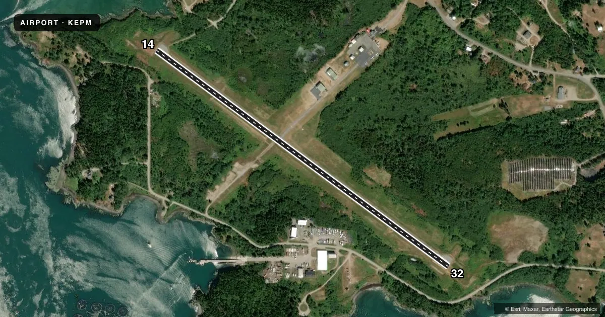
Airport sketch
Runways drawn to scale from FAA survey coordinates, rendered over satellite imagery. Not for navigation.
Approaches & charts
Services on the field
Fuel grades, oxygen, maintenance, ramp storage and lighting — as declared to the FAA by the airport operator.
Fuel & services
- Fuel
- 100LLA+
- Oxygen (bottled)
- Not available
- Oxygen (bulk)
- Not available
- Airframe repair
- Major
- Power plant repair
- Major
Ramp & ground
- Transient storage
- Tie-down
- Landing fee
- No fee published
- Customs
- Not available
- Lighting schedule
- SEE RMK
- Beacon schedule
- SS-SR
- Beacon
- White / Green (civil land)(WG)
- Wind indicator
- Lighted
- Segmented circle
- No
Fuel & FBOs
Cheapest 100LL and Jet A on the field and nearby. Always confirm with the FBO before taxi.
Airport notes
Surface conditions, obstructions, local procedures, lighting outages and other notes published with each FAA cycle.
General notes
- DEER & NMRS BIRDS ON & INVOF RWY.
- REQ CUST AT 207-853-4313.
- 24 HR SELF-SVC FUEL AVBL WITH CREDIT CARD.
- 40-50 FT OBSTN LGTS ON POLES 250 FT R OF CNTRLN NEAR RWY 14 END & APCH AREA.
- FOR CD CTC BOSTON ARTCC AT 603-879-6859.
- JET-A FUEL PUMP LMTD TO OVR WING GRAVITY RFLG OPS.
Lighting notes
- ACTVT REIL RWY 14 & 32; PAPI RWY 14 & 32; MIRL RWY 14/32- 2 CLICKS - CTAF.
Approach & departure obstructions
- 143-5 FT BRUSH 20-200 FT FM THR, 100-200 FT R OF CNTRLN; 8 FT BERM 0-125 FT FM THR, 190 FT R OF CNTRLNE; 6-8 FT BRUSH, 100-200 FT FM THR, 65-200 FT L CNTRLN.
- 323-9 FT WEEDS AND GRASS 100-200 FT FM THR, 75-250 FT R OF CNTRLN; 2-5 FT RISING TERRAIN 50-120 FT FM THR, 125 FT L OF CNTRLN.
- 14PAPI UNUSBL BYD 6 DEGS L OF CNTRLN.
- 14CTLG OBSTN EXCEEDS A 45 DEG SLP.
Other notes
- EXISTED PRIOR TO 1959.
- 5 ACFT PRKG PADS AVBL ON APN.
- ACTVT - CTAF - 2 CLICKS.
- 1CONTACT AIRPORT MANAGER AT 207-214-4751
- 1CONTACT AIRPORT MANAGER AT 207-214-4751
VFR map & nearby airports
VFR sectional. Tap any ICAO chip to open that airport.
Key facts · KEPM
Answer card- ICAO
- KEPM
- Name
- EASTPORT MUNI
- Location
- EASTPORT, MAINE
- Elevation
- 45.3 ft MSL
- Traffic pattern altitude
- 1,045.3 ft MSL (1,000 AGL)
- Control tower
- Non-towered (use CTAF)
- Total runways
- 1
- Longest runway
- 14/32 · 4,002 ft
- Published ILS approaches
- 0
- Published frequencies
- 2
- Magnetic variation
- 16°
- Current flight rules
- VFR
- Current wind
- 120° at 7 kt
- Favored runway now
- RWY 14
Eastport Muni sits in Eastport, Maine. Field elevation is 45.3 ft MSL. The airport has one runway, 14/32, which is 4,002 ft long and asphalt. There is no control tower. CTAF and UNICOM are both 122.8. No ILS approaches are published here.
Pattern altitude is not published. Use the standard 1,000 ft AGL for light piston operations unless the current FAA Chart Supplement says otherwise. The on-field FBO is Eastport Municipal Airport. It carries 100LL and Jet-A Prist. The Jet-A pump is limited to over-wing gravity refueling. Twenty-four hour self-service fuel is available with credit card.
The published remarks matter here. Runway lights, runway end identifier lights and PAPI are available on 14 and 32. The lights come on with 2 clicks on CTAF. There are obstruction lights on poles near the runway 14 end. Brush and a berm are also reported near runway 14. Deer and numerous birds are in the area. Runway 14 has a published PAPI limitation left of centerline, so brief that leg carefully. If you need customs, clearance delivery, or airport manager contact, use the numbers in the current Chart Supplement. This is a small field with real wildlife and obstacle issues near one end. Plan your arrival and departure with that in mind.