METAR & TAF KPNN
KPNN does not publish a METAR.
Showing the nearest reporting station: KMLT (MILLINOCKET MUNI) · 54.3 NM away. Conditions at KPNN may differ.
METAR · KMLT
Observed 19:53Z
KMLT 271953Z AUTO 32003KT 10SM CLR 28/08 A2977 RMK AO2 SLP085 T02780078
- Wind
- 320° @ 3 kt
- Visibility
- 10 SM
- Temp / Dew
- 28°C / 8°C
- Altimeter
- 29.77 inHg
- Clouds
- CLR
- Density alt
- 2,074 ft
- Ceiling
- Unlimited
- Rules
- VFR
Airport info & contacts
Manager on record, flight service, ARTCC, attendance schedule and pattern altitude — published by the FAA and refreshed every 28 days.
Location
- From city
- 2 NM S
- VFR sectional
- HALIFAX
- ARTCC
- ZBW · BOSTON
- NOTAM facility
- BGR (NOTAM-D)
Airport manager
- Name
- BRAD RICHARD
- Phone
- 207-214-5144
- Address
- PO BOX 346, PRINCETON ME 04668
Flight service · Hours
- FSS BGR
- BANGOR1-800-WX-BRIEF
- Attendance
- Unattended
Frequencies
Tap any row to copy the frequency to your clipboard.
Runways & pattern
Full pagePattern entry · RWY 33
LEFT TRAFFIC| Runway | Heading (°M) | Length | Surface | Traffic |
|---|---|---|---|---|
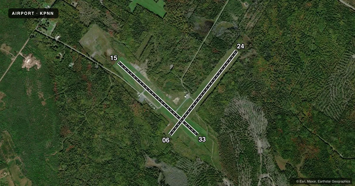
| 15/33Favored | 116° / 296° | 4,007 ft | ASPH | Standard L |
| 06/24 | 22° / 202° | 3,998 ft | ASPH | Standard L |
Runway end performance
| End | TORA | TODA | ASDA | LDA | VGSI | Approach lights | Obstruction |
|---|---|---|---|---|---|---|---|
| 15 | — | — | — | — | PAPI 4-box left(3.5°) | — | 3', tree, 226' from thr, 91' R of cntrln, slope 8 |
| 06 | — | — | — | — | — | — | 25', trees, 201' from thr, 0' R of cntrln, slope 0 |
| 24 | — | — | — | — | — | — | 25', trees, 201' from thr, 0' R of cntrln, slope 0 |
Declared distances in feet. TORA = takeoff run available, TODA = takeoff distance, ASDA = accelerate-stop, LDA = landing distance.
Airport sketch
Runways drawn to scale from FAA survey coordinates, rendered over satellite imagery. Not for navigation.
Approaches & charts
Services on the field
Fuel grades, oxygen, maintenance, ramp storage and lighting — as declared to the FAA by the airport operator.
Fuel & services
- Fuel
- 100LL
- Oxygen (bottled)
- Not available
- Oxygen (bulk)
- Not available
- Airframe repair
- Not available
- Power plant repair
- Not available
Ramp & ground
- Transient storage
- Tie-down
- Landing fee
- No fee published
- Customs
- Not available
- Lighting schedule
- SEE RMK
- Beacon schedule
- SS-SR
- Beacon
- White / Green (civil land)(WG)
- Wind indicator
- Lighted
- Segmented circle
- Yes
Fuel & FBOs
Cheapest 100LL and Jet A on the field and nearby. Always confirm with the FBO before taxi.
Airport notes
Surface conditions, obstructions, local procedures, lighting outages and other notes published with each FAA cycle.
General notes
- WILDLIFE ON & INVOF ARPT.
- FOR CD CTC BOSTON ARTCC AT 603-879-6859.
Lighting notes
- ACTVT PAPI RWY 15; MIRL RWY 15/33 - CTAF.
Fuel notes
- 100LLAVBL 24 HRS WITH MAJOR CREDIT CARD.
Runway surface & condition
- 06/24CLSD INDEFLY - PAVEMENT UNUSBL.
Approach & departure obstructions
- 15BRUSH 100-200 FT L AND 75-170 FT R OF RWY.
- 2420-35 FT TREES 20 FT FM THR, 125 FT L & R ACRS APCH.
- 06RWY 06/24 MKD WITH YELLOW CLOSURE AT BOTH ENDS & MID OF RWY. DTHR MARKINGS ARE NOT VSB.
- 24DTHR NO LONGER VSB.
Other notes
- EXISTED PRIOR TO 1959.
- BRING OWN TIE DOWN ROPES.
- AUTOMATED UNICOM; 3 CLICKS.
VFR map & nearby airports
VFR sectional. Tap any ICAO chip to open that airport.
Key facts · KPNN
Answer card- ICAO
- KPNN
- Name
- PRINCETON MUNI
- Location
- PRINCETON, MAINE
- Elevation
- 264.9 ft MSL
- Traffic pattern altitude
- 1,264.9 ft MSL (1,000 AGL)
- Control tower
- Non-towered (use CTAF)
- Total runways
- 2
- Longest runway
- 15/33 · 4,007 ft
- Published ILS approaches
- 0
- Published frequencies
- 2
- Magnetic variation
- 17°
- Current flight rules
- VFR
- Current wind
- 320° at 3 kt
- Favored runway now
- RWY 33
Princeton Muni is in Princeton, Maine. Field elevation is 264.9 ft MSL. The airport has two asphalt runways. The longest is 4,007 ft on runway 15/33. There is no control tower. CTAF and UNICOM are both 122.7. No ILS approaches are published here.
Pattern altitude is not published. Use 1,000 ft AGL for light piston traffic unless the current FAA Chart Supplement says otherwise. The on-field FBO is Princeton Municipal Airport. It carries 100LL and Jet A Prist. 100LL is available 24 hours with a major credit card. The airport also notes that you should bring your own tie-down ropes.
A few published remarks matter here. Runway 06/24 is closed indefinitely due to unusable pavement. The displaced threshold on runway 24 is no longer visible. Runway 15 has brush near the sides of the runway. Trees also sit close to the approach to runway 24. PAPI is on runway 15. Medium intensity runway lights on 15 and 33 are activated on CTAF. Wildlife is present on and near the airport. If you need clearance delivery, contact Boston ARTCC. First-time pilots should plan for an uncontrolled field with active lighting procedures, local obstructions and a closed runway that should not be used.