METAR & TAF 65B
65B does not publish a METAR.
Showing the nearest reporting station: CYSJ (ST JOHN) · 56.1 NM away. Conditions at 65B may differ.
METAR · CYSJ
Observed 19:00Z
CYSJ 271900Z 12007G15KT 15SM FEW050 FEW270 27/14 A2977 RMK CF1CI1 SLP084 DENSITY ALT 2000FT
- Wind
- 120° @ 7G15 kt
- Visibility
- 15 SM
- Temp / Dew
- 27°C / 14°C
- Altimeter
- 29.77 inHg
- Clouds
- FEW
- Density alt
- 1,731 ft
- Ceiling
- Unlimited
- Rules
- VFR
Airport info & contacts
Manager on record, flight service, ARTCC, attendance schedule and pattern altitude — published by the FAA and refreshed every 28 days.
Location
- From city
- 2 NM W
- VFR sectional
- HALIFAX
- ARTCC
- ZBW · BOSTON
- NOTAM facility
- BGR (NOTAM-D)
Airport manager
- Name
- RENEE GRAY
- Phone
- 207-733-2341
- Address
- TOWN HALL, 40 SCHOOL ST, LUBEC ME 04652
Flight service · Hours
- FSS BGR
- BANGOR1-800-WX-BRIEF
- Attendance
- Unattended
Frequencies
Tap any row to copy the frequency to your clipboard.
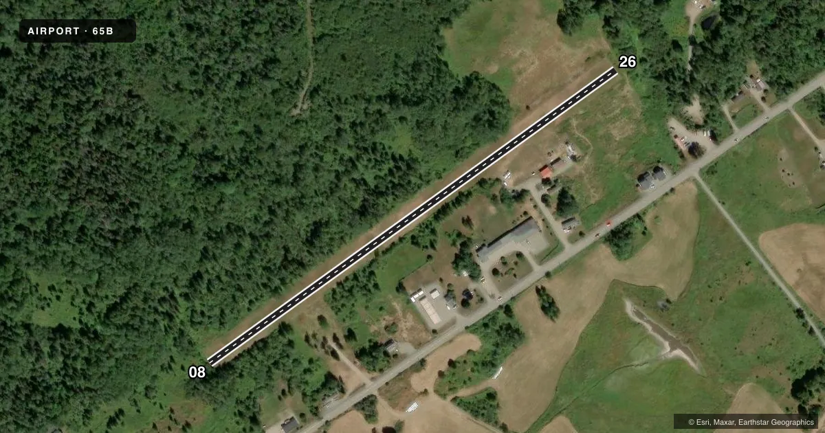
Runways & pattern
Full pagePattern entry · RWY 08
LEFT TRAFFICRunway end performance
| End | TORA | TODA | ASDA | LDA | VGSI | Approach lights | Obstruction |
|---|---|---|---|---|---|---|---|
| 08 | — | — | — | — | — | — | 44', trees, 10' from thr, 63' R of cntrln, slope 0 |
| 26 | — | — | — | — | — | — | 43', tree, 63' from thr, 115' R of cntrln, slope 1 |
Declared distances in feet. TORA = takeoff run available, TODA = takeoff distance, ASDA = accelerate-stop, LDA = landing distance.
Airport sketch
Runways drawn to scale from FAA survey coordinates, rendered over satellite imagery. Not for navigation.
Approaches & charts
Services on the field
Fuel grades, oxygen, maintenance, ramp storage and lighting — as declared to the FAA by the airport operator.
Fuel & services
- Fuel
- Not available
- Oxygen (bottled)
- Not available
- Oxygen (bulk)
- Not available
- Airframe repair
- Not available
- Power plant repair
- Not available
Ramp & ground
- Transient storage
- Tie-down
- Landing fee
- No fee published
- Customs
- Not available
- Lighting schedule
- SEE RMK
- Beacon schedule
- SEE RMK
- Beacon
- White / Green (civil land)(WG)
- Wind indicator
- Yes
- Segmented circle
- No
Fuel & FBOs
Cheapest 100LL and Jet A on the field and nearby. Always confirm with the FBO before taxi.
Airport notes
Surface conditions, obstructions, local procedures, lighting outages and other notes published with each FAA cycle.
General notes
- 24 HR EMERG CALLS TO FIRE STN 733-4641.
- DEER ON & INVOF ARPT.
- CUSTOMS ON REQ 207-733-4331.
- FOR CD CTC BOSTON ARTCC AT 603-879-6859.
Lighting notes
- AVTVT ROTG BCN - CTAF.
- ACTVT LIRL RWY 08/26 - CTAF.
Other notes
- THIS AIRPORT HAS BEEN SURVEYED BY THE NATIONAL GEODETIC SURVEY.
- EXISTED PRIOR TO 1959.
- NO TIE-DOWNS PRVDD, BRING OWN TIE-DOWNS.
- MANAGERTOWN MGR.
VFR map & nearby airports
VFR sectional. Tap any ICAO chip to open that airport.
Key facts · 65B
Answer card- ICAO
- 65B
- Name
- LUBEC MUNI
- Location
- LUBEC, MAINE
- Elevation
- 85 ft MSL
- Traffic pattern altitude
- 1,085 ft MSL (1,000 AGL)
- Control tower
- Non-towered (use CTAF)
- Total runways
- 1
- Longest runway
- 08/26 · 2,024 ft
- Published ILS approaches
- 0
- Published frequencies
- 2
- Magnetic variation
- 20°
- Current flight rules
- VFR
- Current wind
- 120° at 7 kt
- Favored runway now
- RWY 08
LUBEC MUNI sits in Lubec, Maine near the coast. Field elevation is 85 ft MSL. The airport has one runway. Runway 08/26 is 2,024 ft long with a turf-gravel surface. There is no control tower. CTAF and UNICOM are both 122.8. No ILS approaches are published here.
Pattern altitude is not published. Use 1,000 ft AGL for light piston traffic unless the current Chart Supplement says otherwise. The field is small, so plan for short-field work and keep an eye out for deer on and near the airport. The rotating beacon and the low-intensity runway lights for 08/26 are activated by CTAF. That helps for night use, but you still need to verify current field conditions before you go.
There are no on-field FBOs listed. Bring your own tie-downs. For clearance delivery, contact Boston ARTCC at 603-879-6859. Customs services are available on request at 207-733-4331. If you need emergency help after hours, the fire station number in the Chart Supplement is the published contact. The town manager is the airport manager.