METAR & TAF ME5
ME5 does not publish a METAR.
Showing the nearest reporting station: KBHB (HANCOCK COUNTY/BAR HARBOR) · 17.3 NM away. Conditions at ME5 may differ.
METAR · KBHB
Observed 17:56Z
KBHB 271756Z AUTO 20010KT 10SM CLR 26/12 A2980 RMK AO2 SLP093 T02610117 10261 20172 56013 $
- Wind
- 200° @ 10 kt
- Visibility
- 10 SM
- Temp / Dew
- 26°C / 12°C
- Altimeter
- 29.80 inHg
- Clouds
- CLR
- Density alt
- 1,593 ft
- Ceiling
- Unlimited
- Rules
- VFR
Airport info & contacts
Manager on record, flight service, ARTCC, attendance schedule and pattern altitude — published by the FAA and refreshed every 28 days.
Location
- From city
- 5 NM N
- VFR sectional
- HALIFAX
- ARTCC
- ZBW · BOSTON
- NOTAM facility
- BGR (NOTAM-D)
Airport manager
- Name
- WILLIAM H BANKS
- Phone
- 207-460-1113
- Address
- PO BOX 97, SWANS ISLAND ME 04685
Flight service · Hours
- FSS BGR
- BANGOR1-800-WX-BRIEF
- Attendance
- Unattended
Frequencies
Tap any row to copy the frequency to your clipboard.
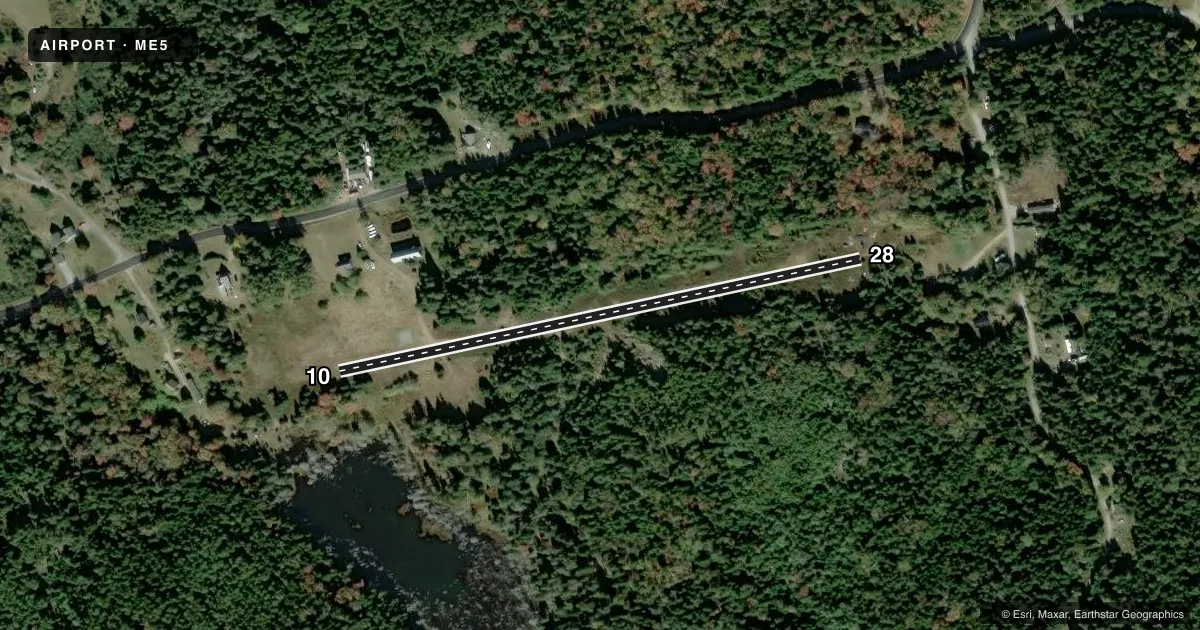
Runways & pattern
Full pagePattern entry · RWY 28
LEFT TRAFFICRunway end performance
| End | TORA | TODA | ASDA | LDA | VGSI | Approach lights | Obstruction |
|---|---|---|---|---|---|---|---|
| 10 | 1,500' | 1,500' | 1,500' | 1,500' | — | — | 40', tree, 20' from thr, 65' R of cntrln, slope 0 |
| 28 | 1,500' | 1,500' | 1,500' | 1,200' | — | — | 25', tree, 1' from thr, 0' R of cntrln, slope 0 |
Declared distances in feet. TORA = takeoff run available, TODA = takeoff distance, ASDA = accelerate-stop, LDA = landing distance.
Airport sketch
Runways drawn to scale from FAA survey coordinates, rendered over satellite imagery. Not for navigation.
Approaches & charts
Services on the field
Fuel grades, oxygen, maintenance, ramp storage and lighting — as declared to the FAA by the airport operator.
Fuel & services
- Fuel
- Not available
Ramp & ground
- Transient storage
- Not published
- Landing fee
- No fee published
- Wind indicator
- No
- Segmented circle
- No
Fuel & FBOs
Cheapest 100LL and Jet A on the field and nearby. Always confirm with the FBO before taxi.
Airport notes
Surface conditions, obstructions, local procedures, lighting outages and other notes published with each FAA cycle.
General notes
- ALL OPS RSTRD TO DALGT VFR ONLY.
- PRIOR TO USING ARPT CALL 207-460-1113.
- ROCK DRAINAGE SWALE ACRS 600 FT FM RWY 28 THR, APRX 40 FT WIDE AT CNTRLN.
- RWY 10/28 +6 FT ROCK LEDGE 50 FT FM CNTRLN, SOUTHSIDE OF ARPT.
- RWY 10: +20 FT TREES 50 FT R OF CNTRLN, 430 FT FM THR.
- WILDLIFE ON & INVOF ARPT.
- HELI COORDS 44 09 54.80N 68 25 48.80W; HELI ELEV 86 FT.
- FOR CD CTC BANGOR APCH AT 207-561-2500 EXTN 1.
- COM TWR 500 FT AGL, 1 MI SE OF RWY.
Runway surface & condition
- H1INGRESS & EGRESS TO HELIPAD BTN 130 & 320 DEGS MAG.
Approach & departure obstructions
- 28DTHR 300 FT; LDA 1200 FT.
- 10APCH SLP GTR THAN 45 DEG.
Other notes
- SEE ASP CASE 99-ANE-8016-NRA.
- 10/28RWY 10/28 SFC ROUGH WITH LRG STONES, STEEP GRADS & NO LN OF SIGHT BTN ENDS.
VFR map & nearby airports
VFR sectional. Tap any ICAO chip to open that airport.
Key facts · ME5
Answer card- ICAO
- ME5
- Name
- BANKS
- Location
- SWANS ISLAND, MAINE
- Elevation
- 100 ft MSL
- Traffic pattern altitude
- 1,100 ft MSL (1,000 AGL)
- Control tower
- Non-towered (use CTAF)
- Total runways
- 1
- Longest runway
- 10/28 · 1,500 ft
- Published ILS approaches
- 0
- Published frequencies
- 3
- Magnetic variation
- 17°
- Current flight rules
- VFR
- Current wind
- 200° at 10 kt
- Favored runway now
- RWY 28
Banks Airport (ME5) is on Swans Island, Maine. The field elevation is 100 ft MSL. It has one runway, 10/28, which is 1,500 ft long and surfaced with gravel. There is no control tower. No ILS approaches are published. The pattern altitude is not published, so use the standard 1,000 ft AGL for light piston operations unless the current FAA Chart Supplement says otherwise.
This is a simple field, but it is not a casual one. Published remarks say the runway surface is rough with large stones and steep gradients. There is no line of sight between the runway ends. A rock drainage swale crosses the runway near the 28 end. Runway 28 also has a 300 ft displaced threshold, so the landing distance available is 1,200 ft. Runway 10 has trees 20 ft high near the right side of the approach path. Wildlife is also reported on and near the airport. A communications tower sits about 1 mile southeast of the runway and rises 500 ft AGL.
Operations are restricted to day VFR only. Before using the airport, call the number in the Chart Supplement or contact Bangor Approach for clearance delivery. There are no on-field FBOs listed. For current local procedures, verify with the airport operator before you go.