METAR & TAF 44B
44B does not publish a METAR.
Showing the nearest reporting station: KBGR (BANGOR INTL) · 28.4 NM away. Conditions at 44B may differ.
METAR · KBGR
Observed 04:53Z
KBGR 270453Z 00000KT 10SM FEW100 12/11 A2986 RMK AO2 SLP109 T01220106 402780094 $
- Wind
- 000° @ 0 kt
- Visibility
- 10 SM
- Temp / Dew
- 12°C / 11°C
- Altimeter
- 29.86 inHg
- Clouds
- FEW
- Density alt
- 359 ft
- Ceiling
- Unlimited
- Rules
- VFR
Airport info & contacts
Manager on record, flight service, ARTCC, attendance schedule and pattern altitude — published by the FAA and refreshed every 28 days.
Location
- From city
- 1 NM SW
- VFR sectional
- MONTREAL
- ARTCC
- ZBW · BOSTON
- NOTAM facility
- BGR (NOTAM-D)
Airport manager
- Name
- CHRIS ARNO
- Phone
- 207-852-1881
- Address
- TOWN OF DOVER-FOXCROFT, 48 MORTON AVE. SUITE A, DOVER-FOXCROFT ME 04425
Flight service · Hours
- FSS BGR
- BANGOR1-800-WX-BRIEF
- Attendance
- Unattended
Frequencies
Tap any row to copy the frequency to your clipboard.
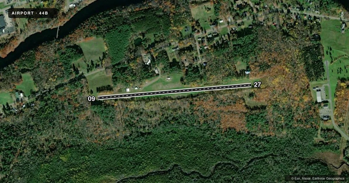
Runways & pattern
Full pagePattern entry · RWY 09
LEFT TRAFFICRunway end performance
| End | TORA | TODA | ASDA | LDA | VGSI | Approach lights | Obstruction |
|---|---|---|---|---|---|---|---|
| 09 | — | — | — | — | — | — | 60', trees, 0' from thr, 0' R of cntrln, slope 0 |
| 27 | — | — | — | — | — | — | 30', trees, 0' from thr, 0' R of cntrln, slope 0 |
Declared distances in feet. TORA = takeoff run available, TODA = takeoff distance, ASDA = accelerate-stop, LDA = landing distance.
Airport sketch
Runways drawn to scale from FAA survey coordinates, rendered over satellite imagery. Not for navigation.
Approaches & charts
Services on the field
Fuel grades, oxygen, maintenance, ramp storage and lighting — as declared to the FAA by the airport operator.
Fuel & services
- Fuel
- Not available
- Oxygen (bottled)
- Not available
- Oxygen (bulk)
- Not available
- Airframe repair
- Not available
- Power plant repair
- Not available
Ramp & ground
- Transient storage
- Tie-down
- Landing fee
- No fee published
- Customs
- Not available
- Wind indicator
- Yes
- Segmented circle
- No
Fuel & FBOs
Cheapest 100LL and Jet A on the field and nearby. Always confirm with the FBO before taxi.
Airport notes
Surface conditions, obstructions, local procedures, lighting outages and other notes published with each FAA cycle.
General notes
- DEER ON & INVOF ARPT.
- NO LINE OF SIGHT BTWN RY ENDS.
- RY 27 +12 FT ROCK AND DIRT PILE 250 FM THLD AND 90 FT R.
- RUNWAY 9-27 HAS 2+INCH ROCK IN CENTER OF RUNWAY 400 FT-600 FT FROM RUNWAY 9 THRESHOLD.
- RUNWAY 27 +10 FT. ROADWAY 110 FT. FROM THRESHOLD ACROSS THE RUNWAY.,
- RUNWAY 27, +60 FT. TREES 300 FT. FROM THRESHOLD ACROSS APPROACH.
- FOR CD CTC BOSTON ARTCC AT 603-879-6859.
Runway surface & condition
- 09/27THLD UNMARKED AND UNDEFINED.
Other notes
- THIS AIRPORT HAS BEEN SURVEYED BY THE NATIONAL GEODETIC SURVEY.
- EXISTED PRIOR TO 1959.
- OWNERTOWN MANAGER - JACK CLUKEY - 207-564-3318.
VFR map & nearby airports
VFR sectional. Tap any ICAO chip to open that airport.
Key facts · 44B
Answer card- ICAO
- 44B
- Name
- CHARLES A CHASE JR MEML FLD
- Location
- DOVER/FOXCROFT, MAINE
- Elevation
- 520 ft MSL
- Traffic pattern altitude
- 1,520 ft MSL (1,000 AGL)
- Control tower
- Non-towered (use CTAF)
- Total runways
- 1
- Longest runway
- 09/27 · 2,926 ft
- Published ILS approaches
- 0
- Published frequencies
- 1
- Magnetic variation
- 19°
- Current flight rules
- VFR
- Current wind
- 000° at 0 kt
- Favored runway now
- –
Charles A Chase Jr Meml Fld sits in Dover/Foxcroft, Maine. Field elevation is 520 ft MSL. The airport has one runway, 09/27, which is 2,926 ft of turf and the longest runway on the field. It is an untowered airport. CTAF is 122.9.
No ILS approaches are published here. Pattern altitude is not published, so use the standard 1,000 ft AGL for light piston operations unless current local guidance says otherwise. That puts the pattern at 1,520 ft MSL based on the field elevation. The runway is not a simple one to read at a glance. The threshold on 09/27 is unmarked and undefined. There is also no line of sight between runway ends.
The published remarks matter here. Deer are reported on and near the airport. Runway 27 has trees close in on the approach side. There is also a roadway across the runway and a rock and dirt pile off to the right near the threshold. Runway 9/27 also has larger rock in the center section of the runway between about 400 ft and 600 ft from the 9 threshold. If you are new to the field, get the current Chart Supplement and talk to the airport operator before arrival. For clearance delivery contact Boston ARTCC at 603-879-6859.