METAR & TAF 3B1
3B1 does not publish a METAR.
Showing the nearest reporting station: KMLT (MILLINOCKET MUNI) · 38.1 NM away. Conditions at 3B1 may differ.
METAR · KMLT
Observed 12:53Z
KMLT 271253Z AUTO 00000KT 10SM CLR 19/12 A2988 RMK AO2 SLP122 T01890122
- Wind
- 000° @ 0 kt
- Visibility
- 10 SM
- Temp / Dew
- 19°C / 12°C
- Altimeter
- 29.88 inHg
- Clouds
- CLR
- Density alt
- 2,268 ft
- Ceiling
- Unlimited
- Rules
- VFR
Airport info & contacts
Manager on record, flight service, ARTCC, attendance schedule and pattern altitude — published by the FAA and refreshed every 28 days.
Location
- From city
- 2 NM E
- VFR sectional
- MONTREAL
- ARTCC
- ZBW · BOSTON
- NOTAM facility
- BGR (NOTAM-D)
Airport manager
- Name
- MICHAEL ROY
- Phone
- 207-695-2421
- Address
- TOWN OFFICE BLDG, GREENVILLE ME 04441
Flight service · Hours
- FSS BGR
- BANGOR1-800-WX-BRIEF
- Attendance
- 0800-1700
Frequencies
Tap any row to copy the frequency to your clipboard.
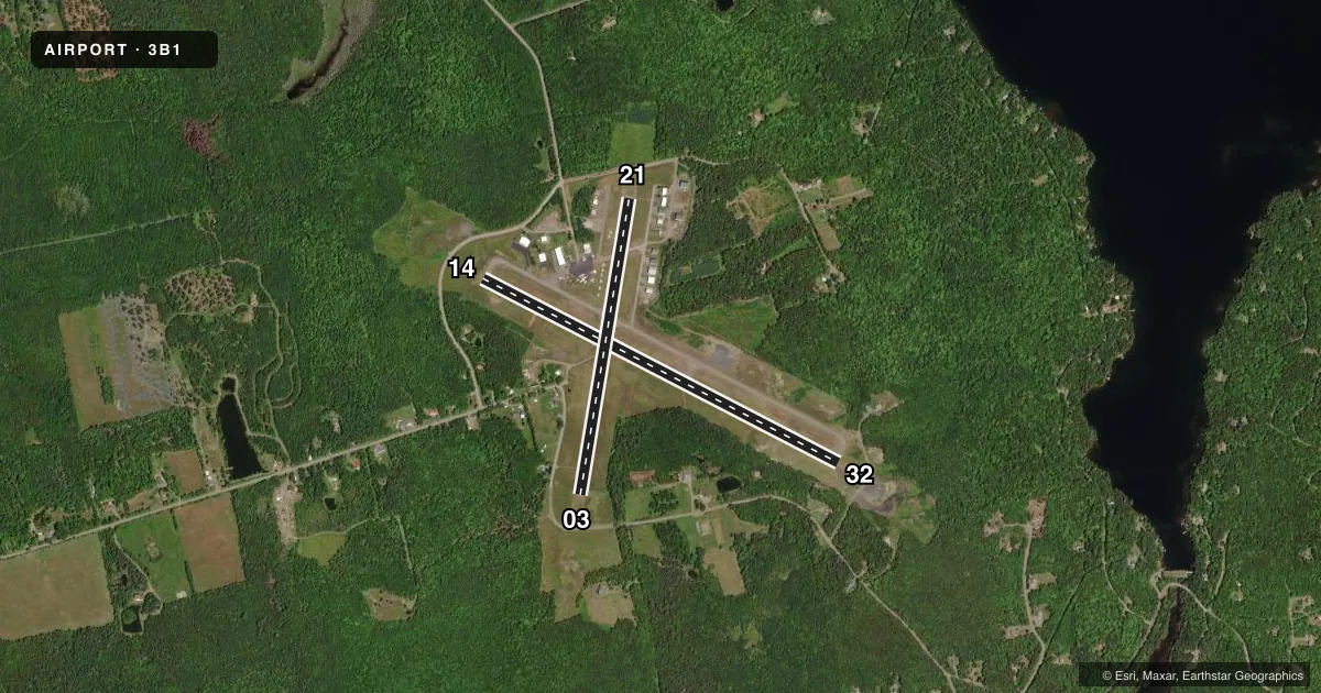
Runways & pattern
Full pagePattern entry · RWY 14
LEFT TRAFFIC| Runway | Heading (°M) | Length | Surface | Traffic |
|---|---|---|---|---|
| 14/32 | 99° / 279° | 4,000 ft | ASPH | Standard L |
| 03/21 | 351° / 171° | 3,001 ft | ASPH | Standard L |
Runway end performance
| End | TORA | TODA | ASDA | LDA | VGSI | Approach lights | Obstruction |
|---|---|---|---|---|---|---|---|
| 14 | — | — | — | — | PAPI 4-box right(3°) | — | — |
| 32 | — | — | — | — | PAPI 4-box left(3.1°) | — | — |
Declared distances in feet. TORA = takeoff run available, TODA = takeoff distance, ASDA = accelerate-stop, LDA = landing distance.
Airport sketch
Runways drawn to scale from FAA survey coordinates, rendered over satellite imagery. Not for navigation.
Approaches & charts
Services on the field
Fuel grades, oxygen, maintenance, ramp storage and lighting — as declared to the FAA by the airport operator.
Fuel & services
- Fuel
- 100LLA
- Oxygen (bottled)
- Not available
- Oxygen (bulk)
- Not available
- Airframe repair
- Major
- Power plant repair
- Major
- Other services
- INSTR,SALES
Ramp & ground
- Transient storage
- Tie-down
- Hangar
- Landing fee
- No fee published
- Customs
- Not available
- Lighting schedule
- SEE RMK
- Beacon schedule
- SS-SR
- Beacon
- White / Green (civil land)(WG)
- Wind indicator
- Lighted
- Segmented circle
- Yes
Fuel & FBOs
Cheapest 100LL and Jet A on the field and nearby. Always confirm with the FBO before taxi.
Airport notes
Surface conditions, obstructions, local procedures, lighting outages and other notes published with each FAA cycle.
General notes
- MOOSE, DEER & OTR WILDLIFE ON & INVOF ARPT.
- COLD TEMPERATURE AIRPORT. ALTITUDE CORRECTION REQUIRED AT OR BELOW -20C.
- BE ALERT: MNT CTAF 122.9 FOR LCL SPB TFC NEARBY (52B & 21M) IF ABLE.
Lighting notes
- DUSK-DAWN. ACTVT REIL RWY 14; PAPI RWY 14 & 32; MIRL RWY 14/32 - CTAF.
Fuel notes
- 100LL24 HR FUEL AVBL WITH MAJOR CREDIT CARD.
Approach & departure obstructions
- 03NRS AND CNTRLN FADED.
- 14NRS AND CNTRLN FADED.
- 21NRS AND CNTRLN FADED.
- 32NRS AND CNTRLN FADED.
- 14PAPI UNUSBL BYD 8 DEGS R OF CNTRLN.
Other notes
- EXISTED PRIOR TO 1959.
- CALL 207-717-5155 FOR HNGR AVBL & FUEL.
- MANAGERTOWN MGR.
VFR map & nearby airports
VFR sectional. Tap any ICAO chip to open that airport.
Key facts · 3B1
Answer card- ICAO
- 3B1
- Name
- GREENVILLE MUNI
- Location
- GREENVILLE, MAINE
- Elevation
- 1,401.8 ft MSL
- Traffic pattern altitude
- 2,401.8 ft MSL (1,000 AGL)
- Control tower
- Non-towered (use CTAF)
- Total runways
- 2
- Longest runway
- 14/32 · 4,000 ft
- Published ILS approaches
- 0
- Published frequencies
- 2
- Magnetic variation
- 18°
- Current flight rules
- VFR
- Current wind
- 000° at 0 kt
- Favored runway now
- –
Greenville Muni is in Greenville, Maine. The field elevation is 1,401.8 ft MSL. It has two asphalt runways. The longest is runway 14/32 at 4,000 ft. There is no control tower. CTAF and UNICOM are both 122.8.
No ILS approaches are published here. Pattern altitude is not published, so use standard light-piston pattern planning at 1,000 ft AGL unless the current Chart Supplement says otherwise. The airport sits in a cold-weather area. Altitude correction is required at or below minus 20 degrees Celsius. Wildlife is also a real factor here. Moose, deer and other animals are reported on and near the airport.
Greenville Municipal Airport is the on-field FBO. It carries 100LL and Jet A. 100LL is available 24 hours with a major credit card. Lighting is available from dusk to dawn. Runway 14 has REILs. Runways 14 and 32 have PAPI and medium intensity runway lights. The PAPI on runway 14 is unusable beyond 8 degrees right of centerline. Runway numbers and centerline markings are faded on 14, 21 and 32. The town manager is the airport manager. Call the airport if you need hangar availability or current fuel details before arrival.