METAR & TAF 21M
21M does not publish a METAR.
Showing the nearest reporting station: KMLT (MILLINOCKET MUNI) · 40.5 NM away. Conditions at 21M may differ.
METAR · KMLT
Observed 12:53Z
KMLT 271253Z AUTO 00000KT 10SM CLR 19/12 A2988 RMK AO2 SLP122 T01890122
- Wind
- 000° @ 0 kt
- Visibility
- 10 SM
- Temp / Dew
- 19°C / 12°C
- Altimeter
- 29.88 inHg
- Clouds
- CLR
- Density alt
- 1,806 ft
- Ceiling
- Unlimited
- Rules
- VFR
Airport info & contacts
Manager on record, flight service, ARTCC, attendance schedule and pattern altitude — published by the FAA and refreshed every 28 days.
Location
- From city
- 0 NM N
- VFR sectional
- MONTREAL
- ARTCC
- ZBW · BOSTON
- NOTAM facility
- BGR (NOTAM-D)
Airport manager
- Name
- ROGER PARADISE
- Phone
- 207-695-2778
- Address
- PO BOX 351, GREENVILLE JUNCTION ME 04442
Flight service · Hours
- FSS BGR
- BANGOR1-800-WX-BRIEF
- Attendance
- MAY-OCT · DALGT
- NOV-APR · Unattended
Frequencies
Tap any row to copy the frequency to your clipboard.
Runways & pattern
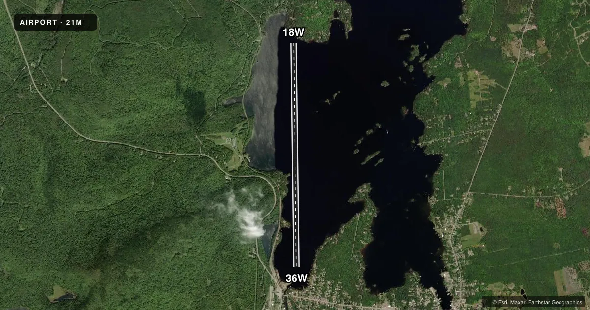
Full pagePattern entry · RWY 18W
LEFT TRAFFICAirport sketch
Runways drawn to scale from FAA survey coordinates, rendered over satellite imagery. Not for navigation.
Approaches & charts
Services on the field
Fuel grades, oxygen, maintenance, ramp storage and lighting — as declared to the FAA by the airport operator.
Fuel & services
- Fuel
- Not available
- Airframe repair
- Not available
- Power plant repair
- Not available
- Other services
- BCHGR
Ramp & ground
- Transient storage
- Not published
- Segmented circle
- No
Fuel & FBOs
Cheapest 100LL and Jet A on the field and nearby. Always confirm with the FBO before taxi.
Airport notes
Surface conditions, obstructions, local procedures, lighting outages and other notes published with each FAA cycle.
General notes
- SPB MAY BE UNUSBL FM MID-NOV TO MID-MAY DUE TO FALL ICE FRMN, SPRING ICE BREAK-UP AND OTHER ADVERSE CONDS. ACFT MAY RQR SKIS DRG WINTER MONTHS DUE TO FROZEN SFC CONDS. FOR SPB CONDS CALL 207-695-2778.
- BE ALERT FOR RECREATIONAL BOATS DRG SUMMER MONTHS AND SNOWMOBILES DRG WINTER MONTHS.
- 150 FT RADIO TWR, 200 FT W OF SEALANE AND 150 FT RADIO TWR, 1000 FT SW OF SEALANE.
- BE ALERT: NEARBY 52B MOOSEHEAD AERO MARINE SPB (1.1 MI EAST) UTILIZE SAME CTAF 122.9. MNT 3B1 CTAF 122.8 IF ABLE FOR LCL TFC.
- FOR CD CTC BOSTON ARTCC AT 603-879-6859.
Other notes
- VFR OPS ONLY. ALL USERS MUST BE IN RADIO CTC WITH EACH OTHER PRIOR TO ENTERING THE TFC PAT DUE TO PROXIMITY WITH MOOSEHEAD AERO MARINE SPB (52B). ALL USERS MUST BE IN RADIO CTC PRIOR TO TKOF.
VFR map & nearby airports
VFR sectional. Tap any ICAO chip to open that airport.
Key facts · 21M
Answer card- ICAO
- 21M
- Name
- CURRIER'S
- Location
- GREENVILLE JUNCTION, MAINE
- Elevation
- 1,029 ft MSL
- Traffic pattern altitude
- 2,029 ft MSL (1,000 AGL)
- Control tower
- Non-towered (use CTAF)
- Total runways
- 1
- Longest runway
- 18W/36W · 10,000 ft
- Published ILS approaches
- 0
- Published frequencies
- 1
- Magnetic variation
- 18°
- Current flight rules
- VFR
- Current wind
- 000° at 0 kt
- Favored runway now
- –
Currier's sits in Greenville Junction, Maine. Field elevation is 1,029 ft MSL. The airport has one runway. It is a 10,000 ft water runway, 18W/36W, with magnetic headings of 179° and 359°. No control tower is published. CTAF is 122.9.
No ILS approaches are published here. Pattern altitude is not published, so use the standard 1,000 ft AGL for light piston aircraft unless the current Chart Supplement says otherwise. There are no on-field FBOs listed. Check with the airport operator or the FBO directly by phone before arrival if you need services.
The published remarks matter here. This is VFR only. Pilots must be in radio contact with each other before entering the pattern and before takeoff because of the nearby Moosehead Aero Marine seaplane base. That seaplane base is 1.1 miles east and uses the same CTAF. The remarks also call out boats in summer and snowmobiles in winter. There are two 150-foot radio towers near Sealane, so keep a sharp visual scan. For clearance delivery, Boston ARTCC is listed in the remarks. If you are planning a winter arrival, check current surface conditions and local use before you go.