METAR & TAF 2B7
2B7 does not publish a METAR.
Showing the nearest reporting station: KWVL (WATERVILLE RGNL) · 19.1 NM away. Conditions at 2B7 may differ.
METAR · KWVL
Observed 09:56Z
KWVL 270956Z AUTO 00000KT 9SM CLR 11/10 A2983 RMK AO2 SLP104 T01060100
- Wind
- 000° @ 0 kt
- Visibility
- 9 SM
- Temp / Dew
- 11°C / 10°C
- Altimeter
- 29.83 inHg
- Clouds
- CLR
- Density alt
- -124 ft
- Ceiling
- Unlimited
- Rules
- VFR
Airport info & contacts
Manager on record, flight service, ARTCC, attendance schedule and pattern altitude — published by the FAA and refreshed every 28 days.
Location
- From city
- 1 NM SE
- VFR sectional
- MONTREAL
- ARTCC
- ZBW · BOSTON
- NOTAM facility
- BGR (NOTAM-D)
Airport manager
- Name
- KATHRYN RUTH
- Phone
- 207-487-3136
- Address
- 112 SOMERSET AVE, PITTSFIELD ME 04967
Flight service · Hours
- FSS BGR
- BANGOR1-800-WX-BRIEF
- Attendance
- 0700-1700
Frequencies
Tap any row to copy the frequency to your clipboard.
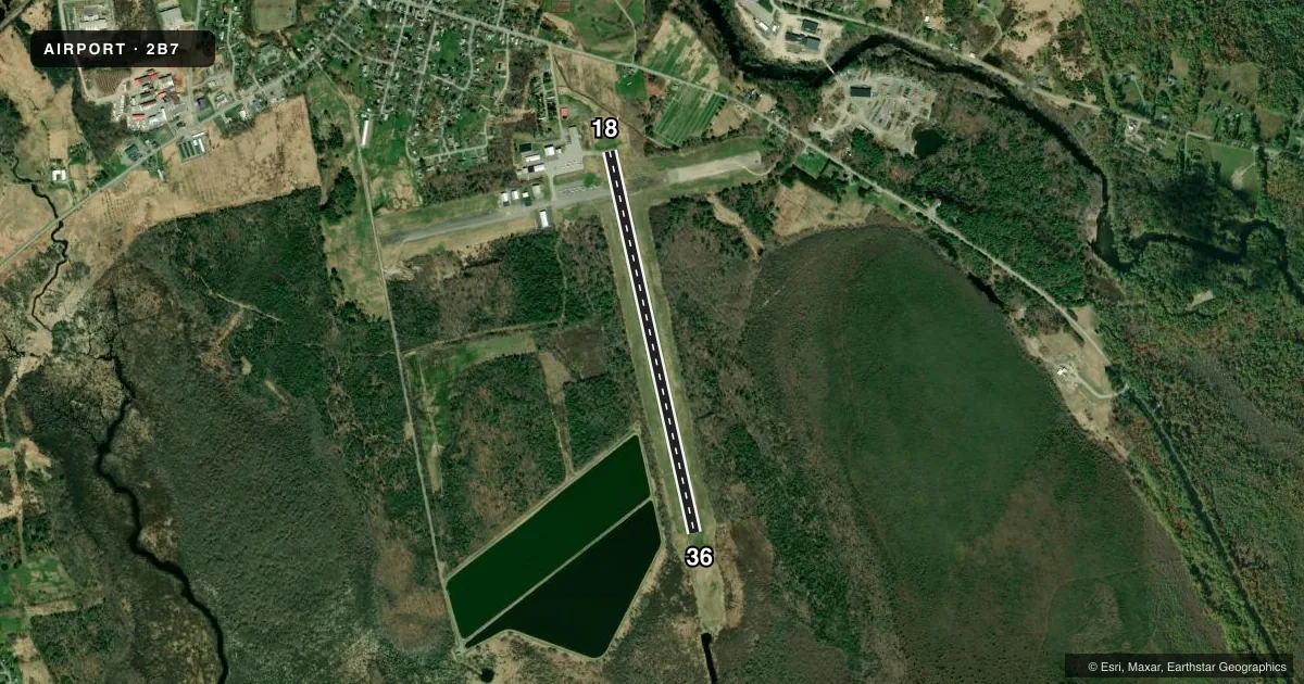
Runways & pattern
Full pagePattern entry · RWY 18
LEFT TRAFFICRunway end performance
| End | TORA | TODA | ASDA | LDA | VGSI | Approach lights | Obstruction |
|---|---|---|---|---|---|---|---|
| 18 | — | — | — | — | — | — | 40', pole, 842' from thr, 257' R of cntrln, slope 16 |
| 36 | — | — | — | — | PAPI 4-box left(3°) | — | 5', brush, 249' from thr, 181' R of cntrln, slope 9 |
Declared distances in feet. TORA = takeoff run available, TODA = takeoff distance, ASDA = accelerate-stop, LDA = landing distance.
Airport sketch
Runways drawn to scale from FAA survey coordinates, rendered over satellite imagery. Not for navigation.
Approaches & charts
Services on the field
Fuel grades, oxygen, maintenance, ramp storage and lighting — as declared to the FAA by the airport operator.
Fuel & services
- Fuel
- 100LLA1+
- Oxygen (bottled)
- Not available
- Oxygen (bulk)
- Not available
- Airframe repair
- Major
- Power plant repair
- Major
- Other services
- CHTR,INSTR,RNTL,SALES
Ramp & ground
- Transient storage
- Tie-down
- Hangar
- Landing fee
- No fee published
- Customs
- Not available
- Lighting schedule
- SEE RMK
- Beacon schedule
- SS-SR
- Beacon
- White / Green (civil land)(WG)
- Wind indicator
- Lighted
- Segmented circle
- Yes
Fuel & FBOs
Cheapest 100LL and Jet A on the field and nearby. Always confirm with the FBO before taxi.
Airport notes
Surface conditions, obstructions, local procedures, lighting outages and other notes published with each FAA cycle.
General notes
- DEER AND TURKEYS INVOF ARPT.
- FOR CD CTC BANGOR APCH AT 207-561-2500 EXTN 1.
Lighting notes
- ACTVT REIL RWY 18 & 36; PAPI RWY 36; MIRL RWY 18/36 - CTAF.
Fuel notes
- 100LL100LL FUEL AFT HRS, CALL 207-232-2318.
Approach & departure obstructions
- 186-10 FT BRUSH, 0-200 FT FM THR, 225-250 FT L OF CNTRLN.
- 3620 FT TREES 0-50 FT FM THR, 210 FT L OF CNTRLN; 8 FT BRUSH 170-200 FT FM THR, 90 FT L OF CNTRLN.
- 18NRS AND CNTRLN FADED OR MISG.
- 36NRS AND CNTRLN FADED OR MISG.
Other notes
- EXISTED PRIOR TO 1959.
- CALL 207-487-5213 FOR HNGR AVBL.
- MANAGERTOWN MGR.
VFR map & nearby airports
VFR sectional. Tap any ICAO chip to open that airport.
Key facts · 2B7
Answer card- ICAO
- 2B7
- Name
- PITTSFIELD MUNI
- Location
- PITTSFIELD, MAINE
- Elevation
- 197.1 ft MSL
- Traffic pattern altitude
- 1,197.1 ft MSL (1,000 AGL)
- Control tower
- Non-towered (use CTAF)
- Total runways
- 1
- Longest runway
- 18/36 · 4,003 ft
- Published ILS approaches
- 0
- Published frequencies
- 4
- Magnetic variation
- 17°
- Current flight rules
- VFR
- Current wind
- 000° at 0 kt
- Favored runway now
- –
Pittsfield Muni sits in Pittsfield, Maine. Field elevation is 197.1 ft MSL. The airport has one runway, 18/36 and it is 4,003 ft long on asphalt. This is an uncontrolled field. CTAF and UNICOM are both 122.8. Bangor Approach handles the approach and departure side. No ILS approaches are published here.
Pattern altitude is not published. Use the standard 1,000 ft AGL pattern for light piston traffic unless the current FAA Chart Supplement says otherwise. Curtis Air is on the field. It carries 100LL and Jet A. 100LL is also listed as available after hours by phone. The published remarks also call out deer and turkeys near the airport. That matters here. Expect wildlife awareness on every taxi and departure.
Runway lighting is available on 18 and 36. Both ends have runway end identifier lights. Runway 36 also has a PAPI. The remarks note faded or missing numbers and centerline markings on both runway ends. There are also tree and brush obstructions near both thresholds, with the more detailed obstruction note on runway 36. If you are planning a night or first-time arrival, get current field details from the FAA Chart Supplement and brief the runway environment before you go.