METAR & TAF 85B
85B does not publish a METAR.
Showing the nearest reporting station: KMLT (MILLINOCKET MUNI) · 27.2 NM away. Conditions at 85B may differ.
METAR · KMLT
Observed 12:53Z
KMLT 271253Z AUTO 00000KT 10SM CLR 19/12 A2988 RMK AO2 SLP122 T01890122
- Wind
- 000° @ 0 kt
- Visibility
- 10 SM
- Temp / Dew
- 19°C / 12°C
- Altimeter
- 29.88 inHg
- Clouds
- CLR
- Density alt
- 1,494 ft
- Ceiling
- Unlimited
- Rules
- VFR
Airport info & contacts
Manager on record, flight service, ARTCC, attendance schedule and pattern altitude — published by the FAA and refreshed every 28 days.
Location
- From city
- 8 NM NW
- VFR sectional
- HALIFAX
- ARTCC
- ZBW · BOSTON
- NOTAM facility
- BGR (NOTAM-D)
Airport manager
- Name
- SCOTTY SKINNER
- Phone
- 207-528-2626
- Address
- 1446 SHIN POND RG., MT. CHASE ME 04765
Flight service · Hours
- FSS BGR
- BANGOR1-800-WX-BRIEF
- Attendance
- DALGT
Frequencies
Tap any row to copy the frequency to your clipboard.
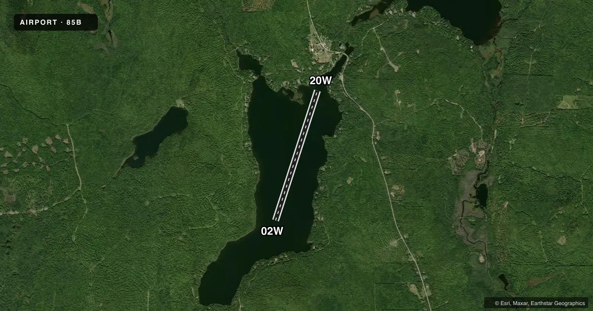
Runways & pattern
Full pagePattern entry · RWY 02W
LEFT TRAFFICAirport sketch
Runways drawn to scale from FAA survey coordinates, rendered over satellite imagery. Not for navigation.
Approaches & charts
Services on the field
Fuel grades, oxygen, maintenance, ramp storage and lighting — as declared to the FAA by the airport operator.
Fuel & services
- Fuel
- 100LL
- Airframe repair
- Not available
- Power plant repair
- Not available
- Other services
- BCHGR
Ramp & ground
- Transient storage
- Tie-down
- Landing fee
- No fee published
- Wind indicator
- No
- Segmented circle
- No
Fuel & FBOs
Cheapest 100LL and Jet A on the field and nearby. Always confirm with the FBO before taxi.
Airport notes
Surface conditions, obstructions, local procedures, lighting outages and other notes published with each FAA cycle.
General notes
- BRIDGE & WIRES BY TIE-UP AREA.
- NUMEROUS BOATS AND CANOES ON LAKE.
- CALL 207-528-2626 FOR SERVICE
- FOR CD CTC BOSTON ARTCC AT 603-879-6859.
Fuel notes
- 100LLFUEL AVAILABLE IN EMERGENCY ONLY.
Other notes
- EXISTED PRIOR TO 1959.
VFR map & nearby airports
VFR sectional. Tap any ICAO chip to open that airport.
Key facts · 85B
Answer card- ICAO
- 85B
- Name
- SHIN POND
- Location
- PATTEN, MAINE
- Elevation
- 778 ft MSL
- Traffic pattern altitude
- 1,778 ft MSL (1,000 AGL)
- Control tower
- Non-towered (use CTAF)
- Total runways
- 1
- Longest runway
- 02W/20W · 6,000 ft
- Published ILS approaches
- 0
- Published frequencies
- 1
- Magnetic variation
- 20°
- Current flight rules
- VFR
- Current wind
- 000° at 0 kt
- Favored runway now
- –
SHIN POND sits in Patten, Maine. The field elevation is 778 ft MSL. It has one runway, 02W/20W, which is a 6,000 ft water runway. No control tower is published here. CTAF is 122.9.
No ILS approaches are published for 85B. The pattern altitude is not published, so use the standard 1,000 ft AGL for light piston operations unless the current Chart Supplement says otherwise. The airport sits in a lake environment. That means you need to watch for boat traffic and canoes on the water. The published remarks also call out a bridge and wires near the tie-up area. Give that area extra attention on arrival and departure.
There is no on-field FBO listed in the facts. Fuel is listed as emergency only for 100LL. For service, the published remarks say to call 207-528-2626. For clearance delivery, contact Boston ARTCC at 603-879-6859. This is an older field that existed before 1959. If you are planning a first stop here, verify current water landing conditions, local traffic and any operational notes in the current FAA Chart Supplement before you go.