METAR & TAF KPQI
Current METAR
Observed 18:56Z
KPQI 271856Z AUTO 13009KT 100V180 10SM CLR 27/10 A2979 RMK AO2 SLP109 T02720100
- Wind
- 130° @ 9 kt
- Visibility
- 10 SM
- Temp / Dew
- 27°C / 10°C
- Altimeter
- 29.79 inHg
- Clouds
- CLR
- Density alt
- 2,263 ft
- Ceiling
- Unlimited
- Rules
- VFR
Airport info & contacts
Manager on record, flight service, ARTCC, attendance schedule and pattern altitude — published by the FAA and refreshed every 28 days.
Location
- From city
- 1 NM NW
- VFR sectional
- HALIFAX
- ARTCC
- ZBW · BOSTON
- NOTAM facility
- PQI (NOTAM-D)
Airport manager
- Name
- SCOTT WARDWELL
- Phone
- 207-764-2550
- Address
- 650 AIRPORT DR SUITE 11, PRESQUE ISLE ME 04769
Flight service · Hours
- FSS BGR
- BANGOR1-800-WX-BRIEF
- Attendance
- 0600-1900
Frequencies
Tap any row to copy the frequency to your clipboard.
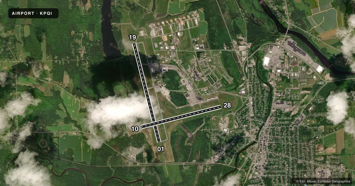
Runways & pattern
Full pagePattern entry · RWY 19
LEFT TRAFFIC| Runway | Heading (°M) | Length | Surface | Traffic |
|---|---|---|---|---|
| 01/19Favored | 329° / 149° | 7,441 ft | ASPH | Standard L |
| 10/28 | 59° / 239° | 6,000 ft | ASPH | Standard L |
Runway end performance
| End | TORA | TODA | ASDA | LDA | VGSI | Approach lights | Obstruction |
|---|---|---|---|---|---|---|---|
| 01 | 7,441' | 7,441' | 7,441' | 7,441' | — | MALSR | — |
| 19 | 7,441' | 7,441' | 7,441' | 7,441' | PAPI 4-box left(3.7°) | — | 115', trees, 2500' from thr, 425' R of cntrln, slope 20 |
| 10 | 6,000' | 6,000' | 6,000' | 6,000' | — | — | 44', tree, 1300' from thr, 0' R of cntrln, slope 25 |
| 28 | 6,000' | 6,000' | 6,000' | 6,000' | PAPI 4-box left(3°) | — | 31', rr, 1200' from thr, 0' R of cntrln, slope 34 |
Declared distances in feet. TORA = takeoff run available, TODA = takeoff distance, ASDA = accelerate-stop, LDA = landing distance.
Airport sketch
Runways drawn to scale from FAA survey coordinates, rendered over satellite imagery. Not for navigation.
Approaches & charts
ILS · 1
Services on the field
Fuel grades, oxygen, maintenance, ramp storage and lighting — as declared to the FAA by the airport operator.
Fuel & services
- Fuel
- 100LLA
- Oxygen (bottled)
- Not available
- Oxygen (bulk)
- Not available
- Airframe repair
- Minor
- Power plant repair
- Minor
- Other services
- AGRI,AMB,CARGO,CHTR,INSTR,RNTL
Ramp & ground
- Transient storage
- Tie-down
- Hangar
- Landing fee
- No fee published
- Customs
- Not available
- Lighting schedule
- SEE RMK
- Beacon schedule
- SS-SR
- Beacon
- White / Green (civil land)(WG)
- Wind indicator
- Lighted
- Segmented circle
- Yes
Fuel & FBOs
Cheapest 100LL and Jet A on the field and nearby. Always confirm with the FBO before taxi.
Airport notes
Surface conditions, obstructions, local procedures, lighting outages and other notes published with each FAA cycle.
General notes
- PAEW ADJ TO RWYS & TWYS (MOWING) MAY 1 THRU NOV 1.
- FOR CD CTC BOSTON ARTCC AT 603-879-6859.
- CTN SML UAS ACT FM SFC TO 400 FT AGL (1040-MSL) 3.5 NM S OF ARPT DUR DALGT HRS.
- COLD TEMPERATURE AIRPORT. ALTITUDE CORRECTION REQUIRED AT OR BELOW -36C.
Lighting notes
- ACTVT MALSR RWY 01; REIL RWY 19; PAPI RWY 19 & 28; HIRL RWY 01/19; MIRL RWY 10/28 - 122.6.
Runway surface & condition
- 01/19PCR VALUE: 220/F/B/X/U
- 10/28PCR VALUE: 220/F/B/X/U
Approach & departure obstructions
- 19PAPI VISUAL GA NON-STD.
Other notes
- EXISTED PRIOR TO 1959.
- CLSD TO UNSKED ACR OPS WITH MORE THAN 30 PAX SEATS, EXCP PPR CALL AMGR 207-764-2550.
VFR map & nearby airports
VFR sectional. Tap any ICAO chip to open that airport.
Key facts · KPQI
Answer card- ICAO
- KPQI
- Name
- PRESQUE ISLE INTL
- Location
- PRESQUE ISLE, MAINE
- Elevation
- 534 ft MSL
- Traffic pattern altitude
- 1,534 ft MSL (1,000 AGL)
- Control tower
- Non-towered (use CTAF)
- Total runways
- 2
- Longest runway
- 01/19 · 7,441 ft
- Published ILS approaches
- 1
- Published frequencies
- 2
- Magnetic variation
- 17°
- Current flight rules
- VFR
- Current wind
- 130° at 9 kt
- Favored runway now
- RWY 19
Presque Isle International is in Presque Isle, Maine. Field elevation is 534 ft MSL. The airport has two asphalt runways. The longest is 01/19 at 7,441 ft. Runway 10/28 is 6,000 ft. There is no control tower, so expect CTAF and UNICOM self-announce traffic on 122.8.
One ILS is published here. It serves runway 01. The pattern altitude is not published, so a first-time pilot should verify the current Chart Supplement before flight. The airport sits in cold-weather country. Altitude correction is required at or below minus 36 degrees Celsius. That matters here when winter air gets very cold. The field also has published lighting notes. Runway 01 uses MALSR. Runway 19 uses REIL and high-intensity lights. Runways 10 and 28 use medium-intensity lights. Activation is on 122.6.
Presque Isle International Airport is the on-field FBO. It carries 100LL, Jet A and Jet A Prist. Call (207) 764-2555 for current service details. The airport also has a published caution for small unmanned aircraft activity south of the field during daylight hours. Clearance delivery is handled through Boston ARTCC at 603-879-6859. The airport is closed to unscheduled air carrier operations with more than 30 passenger seats unless prior permission is obtained from the airport manager.