METAR & TAF 83B
83B does not publish a METAR.
Showing the nearest reporting station: KPQI (PRESQUE ISLE INTL) · 1.2 NM away. Conditions at 83B may differ.
METAR · KPQI
Observed 12:56Z
KPQI 271256Z AUTO 00000KT 10SM CLR 20/14 A2987 RMK AO2 SLP137 T02000139
- Wind
- 000° @ 0 kt
- Visibility
- 10 SM
- Temp / Dew
- 20°C / 14°C
- Altimeter
- 29.87 inHg
- Clouds
- CLR
- Density alt
- 1,282 ft
- Ceiling
- Unlimited
- Rules
- VFR
Airport info & contacts
Manager on record, flight service, ARTCC, attendance schedule and pattern altitude — published by the FAA and refreshed every 28 days.
Location
- From city
- 2 NM NW
- VFR sectional
- HALIFAX
- Pattern altitude
- 1,300 ft AGL · 1,800 ft MSL
- ARTCC
- ZBW · BOSTON
- NOTAM facility
- BGR (NOTAM-D)
Airport manager
- Name
- SCOTT WARDWELL
- Phone
- 207-764-2550
- Address
- 650 AIRPORT DR, SUITE 11, PRESQUE ISLE ME 04769
Flight service · Hours
- FSS BGR
- BANGOR1-800-WX-BRIEF
- Attendance
- UNATDD
Frequencies
Tap any row to copy the frequency to your clipboard.
Runways & pattern
Full pagePattern entry · RWY 01W
LEFT TRAFFICRunway end performance
| End | TORA | TODA | ASDA | LDA | VGSI | Approach lights | Obstruction |
|---|---|---|---|---|---|---|---|
| 01W | — | — | — | — | — | — | 20', trees, 0' from thr, 0' R of cntrln, slope 0 |
| 19W | — | — | — | — | — | — | 20', trees, 0' from thr, 0' R of cntrln, slope 0 |
Declared distances in feet. TORA = takeoff run available, TODA = takeoff distance, ASDA = accelerate-stop, LDA = landing distance.
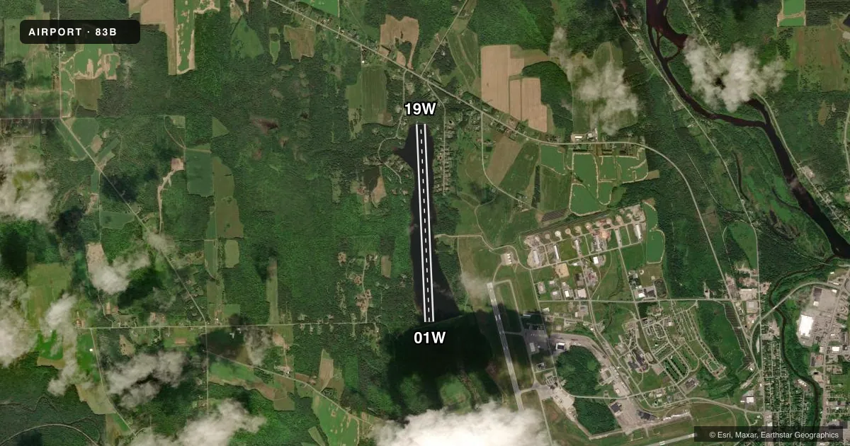
Airport sketch
Runways drawn to scale from FAA survey coordinates, rendered over satellite imagery. Not for navigation.
Approaches & charts
Services on the field
Fuel grades, oxygen, maintenance, ramp storage and lighting — as declared to the FAA by the airport operator.
Fuel & services
- Fuel
- Not available
- Oxygen (bottled)
- Not available
- Oxygen (bulk)
- Not available
Ramp & ground
- Transient storage
- Tie-down
- Landing fee
- No fee published
- Wind indicator
- No
- Segmented circle
- No
Fuel & FBOs
Cheapest 100LL and Jet A on the field and nearby. Always confirm with the FBO before taxi.
Airport notes
Surface conditions, obstructions, local procedures, lighting outages and other notes published with each FAA cycle.
General notes
- ARPT LCTD NW AND INVOF PRESQUE ISLE INTL AIRPORT.
- RISING TERRAIN WEST SIDE OF LAKE.
- FOR CD CTC BOSTON ARTCC AT 603-879-6859.
- N 300 FT OF POND, SUBMERGED TREE STUMPS.
Approach & departure obstructions
- 01WCONTROLLING OBSTN EXCEEDS A 45 DEGREE SLP.
Other notes
- VFR WX CONDS ONLY.
- MORING EYE ON LARGE ROCK AT BOAT RAMP.
- 1FBO SERVICES AVBL: 207-764-2555.
- MANAGEREMERGENCY PHONE: 207-764-2538.
VFR map & nearby airports
VFR sectional. Tap any ICAO chip to open that airport.
Key facts · 83B
Answer card- ICAO
- 83B
- Name
- PRESQUE ISLE
- Location
- PRESQUE ISLE, MAINE
- Elevation
- 500 ft MSL
- Traffic pattern altitude
- 1,800 ft MSL (1,300 AGL)
- Control tower
- Non-towered (use CTAF)
- Total runways
- 1
- Longest runway
- 01W/19W · 6,000 ft
- Published ILS approaches
- 0
- Published frequencies
- 2
- Magnetic variation
- 20°
- Current flight rules
- VFR
- Current wind
- 000° at 0 kt
- Favored runway now
- –
Presque Isle Airport (83B) sits in Presque Isle, Maine. Field elevation is 500 ft MSL. It has one runway. The longest is 6,000 ft on the water, with runway 01W/19W. There is no control tower. CTAF and UNICOM are both 122.8. Pattern altitude is 1,300 ft AGL, which is 1,800 ft MSL.
No ILS approaches are published here. This is a VFR-only field per the published remarks, so plan accordingly and check weather before you go. For clearance delivery, contact Boston Air Route Traffic Control Center at 603-879-6859. The airport is northwest and in the vicinity of Presque Isle International Airport. The remarks also call out rising terrain on the west side of the lake. There is a controlling obstruction near runway 01W. Submerged tree stumps are in the north 300 ft of the pond. That makes a careful look at the water surface and landing path important on arrival.
No on-field FBOs are listed in the facts. Published remarks say fixed base operator services are available by phone at 207-764-2555. If you need current service details, call the airport operator or the FBO directly before departure. The manager emergency number is 207-764-2538. First-time pilots should treat this as a water operation with local hazards, VFR-only limits and no tower support.