METAR & TAF KCAR
Current METAR
Observed 17:54Z
KCAR 271754Z AUTO 18008KT 10SM CLR 26/09 A2979 RMK AO2 SLP090 T02610089 10261 20167 56017
- Wind
- 180° @ 8 kt
- Visibility
- 10 SM
- Temp / Dew
- 26°C / 9°C
- Altimeter
- 29.79 inHg
- Clouds
- CLR
- Density alt
- 2,250 ft
- Ceiling
- Unlimited
- Rules
- VFR
Airport info & contacts
Manager on record, flight service, ARTCC, attendance schedule and pattern altitude — published by the FAA and refreshed every 28 days.
Location
- From city
- 1 NM NW
- VFR sectional
- HALIFAX
- Pattern altitude
- 800 ft AGL · 1,420 ft MSL
- ARTCC
- ZBW · BOSTON
- NOTAM facility
- CAR (NOTAM-D)
Airport manager
- Name
- PENNY THOMPSON
- Phone
- 207-551-9442
- Address
- 25 HIGH STREET, CARIBOU ME 04736
Flight service · Hours
- FSS BGR
- BANGOR1-800-WX-BRIEF
- Attendance
- Unattended
Frequencies
Tap any row to copy the frequency to your clipboard.
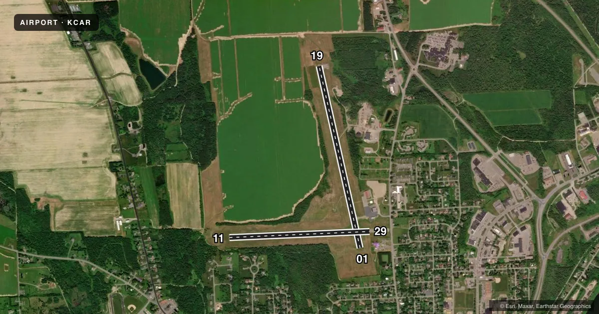
Runways & pattern
Full pagePattern entry · RWY 19
LEFT TRAFFIC| Runway | Heading (°M) | Length | Surface | Traffic |
|---|---|---|---|---|
| 01/19Favored | 330° / 150° | 4,003 ft | ASPH | Standard L |
| 11/29 | 71° / 251° | 3,016 ft | ASPH | Standard L |
Runway end performance
| End | TORA | TODA | ASDA | LDA | VGSI | Approach lights | Obstruction |
|---|---|---|---|---|---|---|---|
| 01 | — | — | — | — | — | — | 7', gnd, 201' from thr, 149' R of cntrln, slope 1 |
| 29 | — | — | — | — | — | — | 34', bldg, 398' from thr, 95' R of cntrln, slope 5 |
Declared distances in feet. TORA = takeoff run available, TODA = takeoff distance, ASDA = accelerate-stop, LDA = landing distance.
Airport sketch
Runways drawn to scale from FAA survey coordinates, rendered over satellite imagery. Not for navigation.
Approaches & charts
Services on the field
Fuel grades, oxygen, maintenance, ramp storage and lighting — as declared to the FAA by the airport operator.
Fuel & services
- Fuel
- 100LL
- Oxygen (bottled)
- Not available
- Oxygen (bulk)
- Not available
- Airframe repair
- Not available
- Power plant repair
- Not available
Ramp & ground
- Transient storage
- Tie-down
- Hangar
- Landing fee
- No fee published
- Customs
- Available
- Lighting schedule
- SEE RMK
- Beacon schedule
- SS-SR
- Beacon
- White / Green (civil land)(WG)
- Wind indicator
- Lighted
- Segmented circle
- Yes
Fuel & FBOs
Cheapest 100LL and Jet A on the field and nearby. Always confirm with the FBO before taxi.
Airport notes
Surface conditions, obstructions, local procedures, lighting outages and other notes published with each FAA cycle.
General notes
- RWY 01/19 OBSTN LGTS ALG BOTH SIDES OF PRIM SFC AND TREE LN.
- RWY 01 +23 FT PWR POLE AND +26 FT TREES, 950 FT FM THR ACRS APCH.
- FOR CD IF UNA TO CTC ON FSS FREQ, CTC BOSTON ARTCC AT 603-879-6859 .
Lighting notes
- ACTVT MIRL RWY 01/19 & 11/29 - CTAF.
Fuel notes
- 100LL24 HR FUEL AVBL WITH CREDIT CARD.
Approach & departure obstructions
- 01GND 0-200 FT FM EOR 100-250 FT R OF CNTRLN RISING TO +8 FT.
- 29GND ON BOTH SIDES RISING TO +3 FT 200 FT FM RWY END.
- 29524 FT DTHR; +302 FT BLAST PAD BYD END OF RWY.
- 2924:1 RATIO TO DTHR.
Other notes
- EXISTED PRIOR TO 1959.
- 800 FT AGL LGT ACFT; 1000 FT AGL MULTI & LRG SNGL ENG ACFT.
- CALL 207-493-3324 FOR HNGR AVBL.
VFR map & nearby airports
VFR sectional. Tap any ICAO chip to open that airport.
Key facts · KCAR
Answer card- ICAO
- KCAR
- Name
- CARIBOU MUNI
- Location
- CARIBOU, MAINE
- Elevation
- 620.3 ft MSL
- Traffic pattern altitude
- 1,420.3 ft MSL (800 AGL)
- Control tower
- Non-towered (use CTAF)
- Total runways
- 2
- Longest runway
- 01/19 · 4,003 ft
- Published ILS approaches
- 0
- Published frequencies
- 2
- Magnetic variation
- 17°
- Current flight rules
- VFR
- Current wind
- 180° at 8 kt
- Favored runway now
- RWY 19
Caribou Muni sits in Caribou, Maine. The field elevation is 620.3 ft MSL. It has two asphalt runways. The longest is runway 01/19 at 4,003 ft. Runway 11/29 is 3,016 ft. There is no control tower. CTAF and UNICOM are both 122.8.
No ILS approaches are published here. Pattern altitude is 800 ft AGL for light aircraft. That works out to 1,420.3 ft MSL. Multi-engine and large single-engine aircraft use 1,000 ft AGL. The airport uses medium intensity runway lights on both runways. They are activated by keying the common traffic advisory frequency.
Caribou Municipal Airport is the on-field FBO. It carries 100LL. 24-hour fuel is available with credit card. Call the field directly at (207) 493-4237 for FBO details. Hangar availability is handled at 207-493-3324.
There are a few items a first-time pilot should brief. Runway 01 has terrain and tree obstructions near the approach end. Runway 29 has a displaced threshold with a blast pad beyond the runway end. The airport also notes obstruction lighting along both sides of runway 01/19 and the tree line. If you need clearance delivery and cannot reach flight service, Boston ARTCC is listed as the backup contact. Check the current FAA Chart Supplement for any current operational notes before you go.