METAR & TAF KHUL
Current METAR
Observed 17:53Z
KHUL 271753Z AUTO 19006KT 10SM CLR 27/09 A2979 RMK AO2 SLP086 T02720089 10272 20161 56019
- Wind
- 190° @ 6 kt
- Visibility
- 10 SM
- Temp / Dew
- 27°C / 9°C
- Altimeter
- 29.79 inHg
- Clouds
- CLR
- Density alt
- 2,208 ft
- Ceiling
- Unlimited
- Rules
- VFR
Airport info & contacts
Manager on record, flight service, ARTCC, attendance schedule and pattern altitude — published by the FAA and refreshed every 28 days.
Location
- From city
- 2 NM E
- VFR sectional
- HALIFAX
- ARTCC
- ZBW · BOSTON
- NOTAM facility
- HUL (NOTAM-D)
Airport manager
- Name
- CHRISTOPHER STEWART
- Phone
- (207) 532-1325
- Address
- 21 WATER ST., HOULTON ME 04730
Flight service · Hours
- FSS BGR
- BANGOR1-800-WX-BRIEF
- Attendance
- NOV-APR · MON-FRI · 0700-1530
- SAT-SUN · Unattended
- MAY-OCT · MON-FRI · 0600-1630
Frequencies
Tap any row to copy the frequency to your clipboard.
Runways & pattern
Full pagePattern entry · RWY 19
LEFT TRAFFIC| Runway | Heading (°M) | Length | Surface | Traffic |
|---|---|---|---|---|
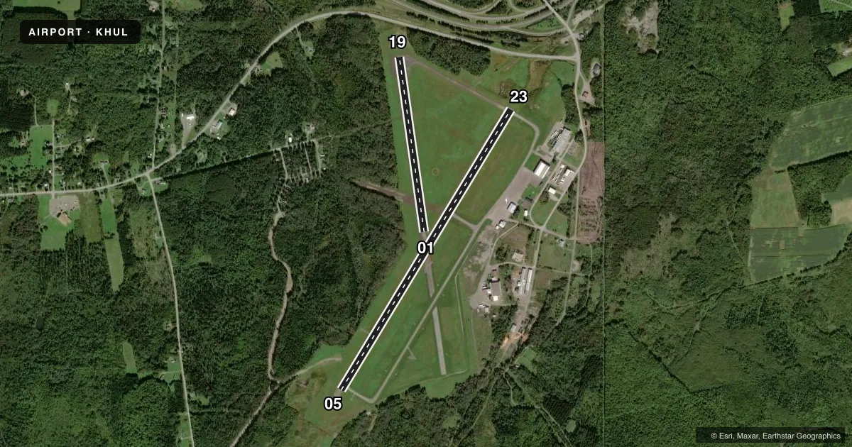
| 05/23 | 13° / 193° | 5,015 ft | ASPH | Standard L |
| 01/19Favored | 334° / 154° | 2,700 ft | ASPH | Standard L |
Runway end performance
| End | TORA | TODA | ASDA | LDA | VGSI | Approach lights | Obstruction |
|---|---|---|---|---|---|---|---|
| 05 | — | — | — | — | PAPI 4-box left(3°) | — | — |
Declared distances in feet. TORA = takeoff run available, TODA = takeoff distance, ASDA = accelerate-stop, LDA = landing distance.
Airport sketch
Runways drawn to scale from FAA survey coordinates, rendered over satellite imagery. Not for navigation.
Approaches & charts
Services on the field
Fuel grades, oxygen, maintenance, ramp storage and lighting — as declared to the FAA by the airport operator.
Fuel & services
- Fuel
- 100LLA+A1+
- Oxygen (bottled)
- Not available
- Oxygen (bulk)
- Not available
- Airframe repair
- Major
- Power plant repair
- Major
- Other services
- AMB
Ramp & ground
- Transient storage
- Tie-down
- Hangar
- Landing fee
- No fee published
- Customs
- Available
- Lighting schedule
- SEE RMK
- Beacon schedule
- SS-SR
- Beacon
- White / Green (civil land)(WG)
- Wind indicator
- Lighted
- Segmented circle
- Yes
Fuel & FBOs
Cheapest 100LL and Jet A on the field and nearby. Always confirm with the FBO before taxi.
Airport notes
Surface conditions, obstructions, local procedures, lighting outages and other notes published with each FAA cycle.
General notes
- USDA RECATERING FAC AVBL.
- DEER ON & INVOF ARPT.
- FOR AFT HRS ACES TO TRML BLDG USE FREQ 122.8.
- FOR CD IF UNA TO CTC ON FSS FREQ, CTC BOSTON ARTCC AT 603-879-6859 .
Lighting notes
- DUSK-DAWN. ACTVT REIL RWY 05 & 23; PAPI RWY 05; MIRL RWY 05/23 - CTAF.
Fuel notes
- 100LLFOR JET A FUEL AFT HRS CALL 207-538-7997. 100 LL IS AVBL 24 HRS WITH MAJOR CREDIT CARD.
Approach & departure obstructions
- 01FADED.
- 19FADED.
Other notes
- EXISTED PRIOR TO 1959.
- MANAGERALTN: 207-538-7997.
VFR map & nearby airports
VFR sectional. Tap any ICAO chip to open that airport.
Key facts · KHUL
Answer card- ICAO
- KHUL
- Name
- HOULTON INTL
- Location
- HOULTON, MAINE
- Elevation
- 489.4 ft MSL
- Traffic pattern altitude
- 1,489.4 ft MSL (1,000 AGL)
- Control tower
- Non-towered (use CTAF)
- Total runways
- 2
- Longest runway
- 05/23 · 5,015 ft
- Published ILS approaches
- 0
- Published frequencies
- 2
- Magnetic variation
- 18°
- Current flight rules
- VFR
- Current wind
- 190° at 6 kt
- Favored runway now
- RWY 19
Houlton Intl is in Houlton, Maine. The field elevation is 489.4 ft MSL. It has two asphalt runways. The longest is runway 05/23 at 5,015 ft. There is no control tower, so local traffic uses CTAF and UNICOM 122.8. No ILS approaches are published here.
Pattern altitude is not published. Use the standard 1,000 ft AGL pattern for light piston operations unless the current Chart Supplement says otherwise. Runway 05/23 has runway end identifier lights, a PAPI on runway 05 and medium intensity runway lights that you can activate by radio from dusk to dawn. Runway 01 markings are faded. Runway 19 markings are faded too. Deer are reported on and near the airport. Keep a sharp scan on taxi, takeoff and landing.
Houlton International Airport is the on-field FBO. It carries 100LL and Jet A Prist. 100LL is available 24 hours with a major credit card. For after-hours terminal access, use 122.8. The airport also notes alternate manager contact at 207-538-7997. For clearance delivery when Flight Service is not available, Boston ARTCC can help at 603-879-6859. This is a non-towered field with a short secondary runway at 2,700 ft. Plan your performance and runway choice with the current conditions in mind.