METAR & TAF 7ME
7ME does not publish a METAR.
Showing the nearest reporting station: KFVE (NORTHERN AROOSTOOK RGNL) · 11.9 NM away. Conditions at 7ME may differ.
METAR · KFVE
Observed 02:53Z
KFVE 270253Z AUTO 13003KT 10SM CLR 19/10 A2987 RMK AO2 SLP109 T01940100 50004
- Wind
- 130° @ 3 kt
- Visibility
- 10 SM
- Temp / Dew
- 19°C / 10°C
- Altimeter
- 29.87 inHg
- Clouds
- CLR
- Density alt
- 1,420 ft
- Ceiling
- Unlimited
- Rules
- VFR
Airport info & contacts
Manager on record, flight service, ARTCC, attendance schedule and pattern altitude — published by the FAA and refreshed every 28 days.
Location
- From city
- 3 NM SSE
- VFR sectional
- HALIFAX
- ARTCC
- ZBW · BOSTON
- NOTAM facility
- BGR (NOTAM-D)
Airport manager
- Name
- FISH RIVER FLYING CLUB
- Phone
- 207-231-2286
- Address
- GEORGE DUMOND, 14 PAGE AVE, FORT KENT ME 04743
Flight service · Hours
- FSS BGR
- BANGOR1-800-WX-BRIEF
Frequencies
Tap any row to copy the frequency to your clipboard.
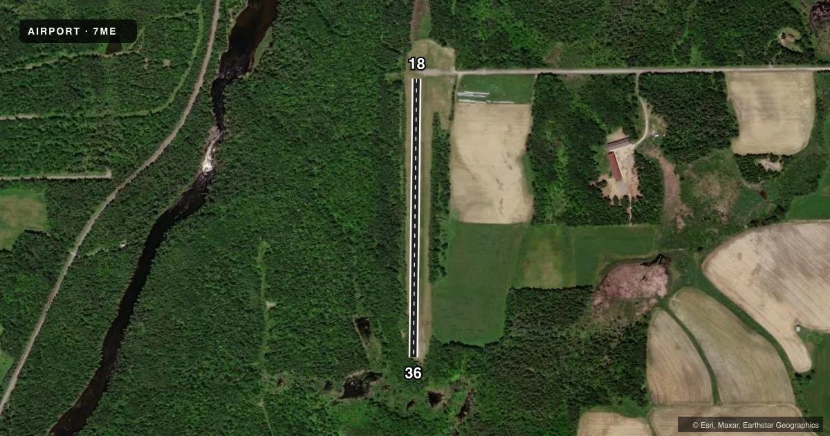
Runways & pattern
Full pagePattern entry · RWY 18
LEFT TRAFFICAirport sketch
Runways drawn to scale from FAA survey coordinates, rendered over satellite imagery. Not for navigation.
Approaches & charts
Services on the field
Fuel grades, oxygen, maintenance, ramp storage and lighting — as declared to the FAA by the airport operator.
Fuel & services
- Fuel
- Not available
Ramp & ground
- Transient storage
- Not published
Fuel & FBOs
Cheapest 100LL and Jet A on the field and nearby. Always confirm with the FBO before taxi.
Airport notes
Surface conditions, obstructions, local procedures, lighting outages and other notes published with each FAA cycle.
VFR map & nearby airports
VFR sectional. Tap any ICAO chip to open that airport.
Key facts · 7ME
Answer card- ICAO
- 7ME
- Name
- FORT KENT MUNI
- Location
- FORT KENT, MAINE
- Elevation
- 708 ft MSL
- Traffic pattern altitude
- 1,708 ft MSL (1,000 AGL)
- Control tower
- Non-towered (use CTAF)
- Total runways
- 1
- Longest runway
- 18/36 · 2,140 ft
- Published ILS approaches
- 0
- Published frequencies
- 1
- Magnetic variation
- –
- Current flight rules
- VFR
- Current wind
- 130° at 3 kt
- Favored runway now
- RWY 18
Fort Kent Muni sits in Fort Kent, Maine. Field elevation is 708 ft MSL. The airport has one runway. Runway 18/36 is 2,140 ft of turf with magnetic headings of 181° and 1°. That makes it a short-field turf strip, so plan accordingly if you are bringing in a heavier airplane or operating after rain or during soft-field conditions.
There is no control tower. CTAF is 122.9. No ILS approaches are published here, so you will be working with non-precision or visual options only. The pattern altitude is not published. For light piston traffic, use the standard 1,000 ft AGL pattern unless the current FAA Chart Supplement says otherwise. At this field that works out to about 1,708 ft MSL.
No on-field FBOs are listed. Plan on verifying services directly with the airport operator before you go. There are no published remarks in the cleaned Chart Supplement data. Fort Kent is a northern Maine airport, so weather and surface conditions can change fast. Check the current Chart Supplement for any local notes before departure. If you are new to the field, treat the turf runway and short length as the main operational limits.