METAR & TAF 39B
39B does not publish a METAR.
Showing the nearest reporting station: KMLT (MILLINOCKET MUNI) · 40.6 NM away. Conditions at 39B may differ.
METAR · KMLT
Observed 15:53Z
KMLT 271553Z AUTO 00000KT 10SM CLR 26/09 A2984 RMK AO2 SLP107 T02560094
- Wind
- 000° @ 0 kt
- Visibility
- 10 SM
- Temp / Dew
- 26°C / 9°C
- Altimeter
- 29.84 inHg
- Clouds
- CLR
- Density alt
- 2,591 ft
- Ceiling
- Unlimited
- Rules
- VFR
Airport info & contacts
Manager on record, flight service, ARTCC, attendance schedule and pattern altitude — published by the FAA and refreshed every 28 days.
Location
- From city
- 11 NM NE
- VFR sectional
- MONTREAL
- ARTCC
- ZBW · BOSTON
- NOTAM facility
- BGR (NOTAM-D)
Airport manager
- Name
- ROB FLEWELLING
- Phone
- 207-944-5991
- Address
- NUGENT CAMPS, P.O. BOX 209, MILLINOCKET ME 00044
Flight service · Hours
- FSS BGR
- BANGOR1-800-WX-BRIEF
- Attendance
- ALL
Frequencies
Tap any row to copy the frequency to your clipboard.
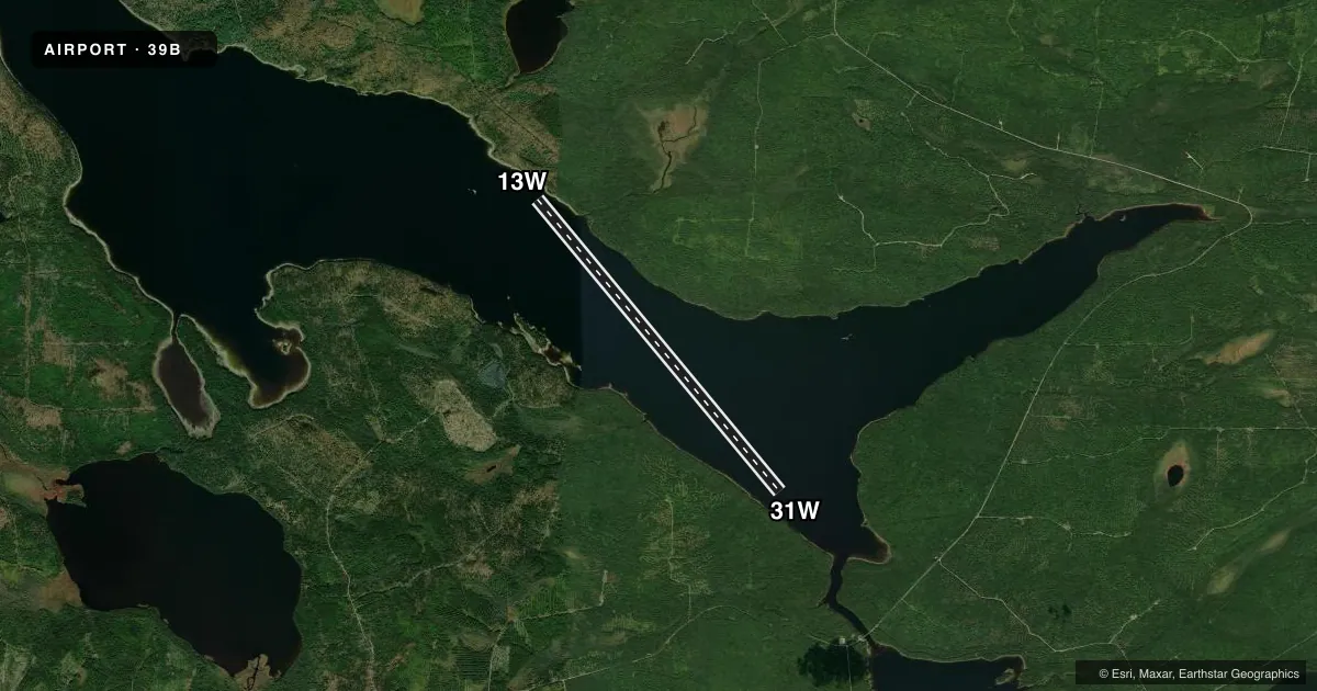
Runways & pattern
Full pagePattern entry · RWY 13W
LEFT TRAFFICAirport sketch
Runways drawn to scale from FAA survey coordinates, rendered over satellite imagery. Not for navigation.
Approaches & charts
Services on the field
Fuel grades, oxygen, maintenance, ramp storage and lighting — as declared to the FAA by the airport operator.
Fuel & services
- Fuel
- Not available
- Airframe repair
- Not available
- Power plant repair
- Not available
Ramp & ground
- Transient storage
- Not published
- Landing fee
- No fee published
- Wind indicator
- No
- Segmented circle
- No
Fuel & FBOs
Cheapest 100LL and Jet A on the field and nearby. Always confirm with the FBO before taxi.
Airport notes
Surface conditions, obstructions, local procedures, lighting outages and other notes published with each FAA cycle.
General notes
- ONE ROCK 1 1/2 MI WEST OF CAMPS NEAR CENTER OF LAKE.
- FOR SVCS CALL 207-944-5991 IN ADVANCE.
- FOR CD CTC BOSTON ARTCC AT 603-879-6859.
Other notes
- EXISTED PRIOR TO 1959.
- DOCK
VFR map & nearby airports
VFR sectional. Tap any ICAO chip to open that airport.
Key facts · 39B
Answer card- ICAO
- 39B
- Name
- NUGENT CHAMBERLAIN LAKE
- Location
- CHESUNCOOK, MAINE
- Elevation
- 945 ft MSL
- Traffic pattern altitude
- 1,945 ft MSL (1,000 AGL)
- Control tower
- Non-towered (use CTAF)
- Total runways
- 1
- Longest runway
- 13W/31W · 15,000 ft
- Published ILS approaches
- 0
- Published frequencies
- 1
- Magnetic variation
- 19°
- Current flight rules
- VFR
- Current wind
- 000° at 0 kt
- Favored runway now
- –
Nugent Chamberlain Lake is in Chesuncook, Maine. The field elevation is 945 ft MSL. It has one runway. The longest is 15,000 ft on water, runway 13W/31W. The runway headings are 140° and 320° magnetic. There is no control tower. CTAF is 122.9.
No ILS approaches are published here. Pattern altitude is not published, so use the standard 1,000 ft AGL for light piston operations unless the current FAA Chart Supplement says otherwise. There are no on-field FBOs listed. For services, call 207-944-5991 in advance. For clearance delivery, contact Boston ARTCC at 603-879-6859.
This is a water field in a remote part of Maine. Plan for lake operations and check the current Chart Supplement before you go. One published remark notes a rock about 1.5 miles west of camps near the center of the lake. Another note says there is a dock. The field existed before 1959. If you are new to the area, pay close attention to local water conditions. Also watch shoreline references and any lake traffic before you set up for landing or departure.