METAR & TAF 5B2
5B2 does not publish a METAR.
Showing the nearest reporting station: KSCH (SCHENECTADY COUNTY) · 12.3 NM away. Conditions at 5B2 may differ.
METAR · KSCH
Observed 11:45Z
KSCH 271145Z 22004KT 10SM CLR 22/18 A2985
- Wind
- 220° @ 4 kt
- Visibility
- 10 SM
- Temp / Dew
- 22°C / 18°C
- Altimeter
- 29.85 inHg
- Clouds
- CLR
- Density alt
- 1,465 ft
- Ceiling
- Unlimited
- Rules
- VFR
Airport info & contacts
Manager on record, flight service, ARTCC, attendance schedule and pattern altitude — published by the FAA and refreshed every 28 days.
Location
- From city
- 3 NM SW
- VFR sectional
- NEW YORK
- Pattern altitude
- 767 ft AGL · 1,201 ft MSL
- ARTCC
- ZBW · BOSTON
- NOTAM facility
- 5B2 (NOTAM-D)
Airport manager
- Name
- JON ZILKA
- Phone
- 518-885-5470
- Address
- 405 GREENFIELD AVE., BALLSTON SPA NY 12020
Flight service · Hours
- FSS BTV
- BURLINGTON1-800-WX-BRIEF
- Attendance
- 0730-DUSK
Frequencies
Tap any row to copy the frequency to your clipboard.
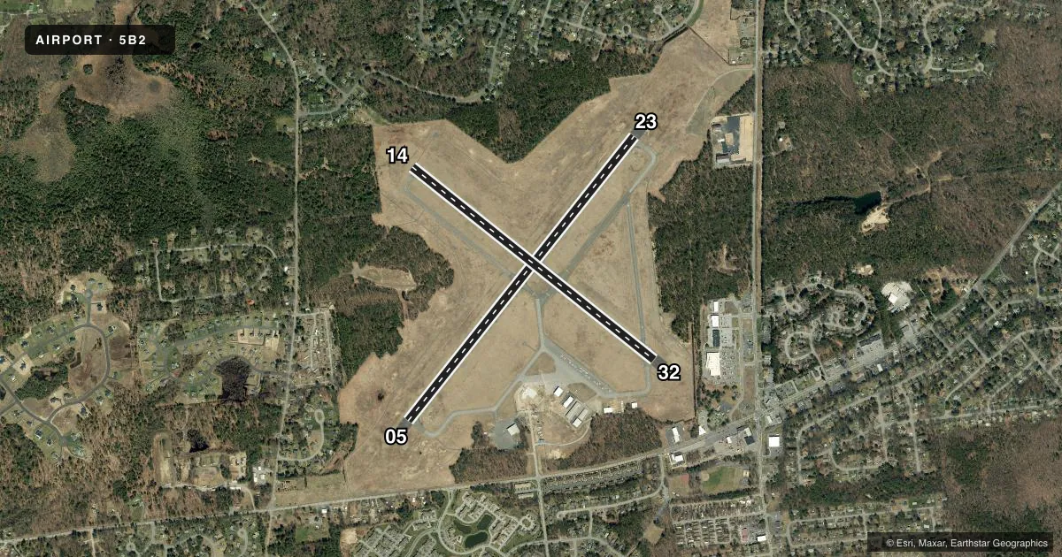
Runways & pattern
Full pagePattern entry · RWY 23
LEFT TRAFFIC| Runway | Heading (°M) | Length | Surface | Traffic |
|---|---|---|---|---|
| 05/23Favored | 25° / 205° | 4,699 ft | ASPH-CONC | Standard L |
| 14/32 | 115° / 295° | 4,000 ft | ASPH-CONC | Standard L |
Runway end performance
| End | TORA | TODA | ASDA | LDA | VGSI | Approach lights | Obstruction |
|---|---|---|---|---|---|---|---|
| 05 | — | — | — | — | — | — | 89', trees, 1579' from thr, 194' R of cntrln, slope 15 |
| 23 | — | — | — | — | PAPI 2-box left(3°) | — | 89', trees, 1876' from thr, 88' R of cntrln, slope 18 |
| 14 | — | — | — | — | — | — | 69', trees, 455' from thr, 222' R of cntrln, slope 3 |
| 32 | — | — | — | — | — | — | 73', trees, 713' from thr, 72' R of cntrln, slope 7 |
Declared distances in feet. TORA = takeoff run available, TODA = takeoff distance, ASDA = accelerate-stop, LDA = landing distance.
Airport sketch
Runways drawn to scale from FAA survey coordinates, rendered over satellite imagery. Not for navigation.
Approaches & charts
Services on the field
Fuel grades, oxygen, maintenance, ramp storage and lighting — as declared to the FAA by the airport operator.
Fuel & services
- Fuel
- 100LLA
- Oxygen (bottled)
- Low pressure
- Oxygen (bulk)
- Not available
- Airframe repair
- Major
- Power plant repair
- Major
- Other services
- AVNCS,CHTR,INSTR,SALES
Ramp & ground
- Transient storage
- Tie-down
- Hangar
- Landing fee
- No fee published
- Customs
- Not available
- Lighting schedule
- SEE RMK
- Beacon schedule
- SS-SR
- Beacon
- White / Green (civil land)(WG)
- Wind indicator
- Yes
- Segmented circle
- No
Fuel & FBOs
Cheapest 100LL and Jet A on the field and nearby. Always confirm with the FBO before taxi.
Airport notes
Surface conditions, obstructions, local procedures, lighting outages and other notes published with each FAA cycle.
General notes
- JET OR TURBINE ACFT USE 5 OR 23.
- GLIDER ACTVTY ON WKENDS & OCNLY WKDAYS WITH EXTENSIVE PRE-LAUNCH & AFTER LDG GND OPNS ON SHOULDERS OF RY IN USE.
- ALBANY ANG HELS DO TGL OPNS USUALLY DURG DALGT HRS.
- YEAR ROUND FEDERALLY & STATE PROTECTED HABITAT FOR KARNER BLUE BUTTERFLY; UNAUTHORIZED OFF-PAVEMENT OPNS PROHIBITED.
- GCO AVBL ON FREQ 118.125 THRU ALB CLEARANCE DELIVERY.
- FOR CD IF GCO UNA CTC ALBANY APCH AT 518-862-2299.
Lighting notes
- ACTVT REIL RWY 05/23; MIRL RWY 05/23 - CTAF.
Runway surface & condition
- 14/32RY LIGHTS OTS.
Approach & departure obstructions
- 32PAVED SVC ROAD 186 FT LEFT OF CTRLN, ALONG RWY TO TXY C.
Other notes
- UNKNOWN.
- PEAK DURING RACING SEASON.
- MANAGERFBO
- OWNERGREG BALL, SARATOGA CO DPW.
VFR map & nearby airports
VFR sectional. Tap any ICAO chip to open that airport.
Key facts · 5B2
Answer card- ICAO
- 5B2
- Name
- SARATOGA COUNTY
- Location
- SARATOGA SPRINGS, NEW YORK
- Elevation
- 433.9 ft MSL
- Traffic pattern altitude
- 1,200.9 ft MSL (767 AGL)
- Control tower
- Non-towered (use CTAF)
- Total runways
- 2
- Longest runway
- 05/23 · 4,699 ft
- Published ILS approaches
- 0
- Published frequencies
- 4
- Magnetic variation
- 14°
- Current flight rules
- VFR
- Current wind
- 220° at 4 kt
- Favored runway now
- RWY 23
Saratoga County Airport sits in Saratoga Springs, New York. Field elevation is 433.9 ft MSL. The airport has two runways. The longest is 05/23 at 4,699 ft. Runway 14/32 is 4,000 ft. There is no control tower. CTAF and UNICOM are both 123.075.
No ILS approaches are published here. Pattern altitude is 767 ft AGL, which is 1,200.9 ft MSL. North American Flight Services is the on-field FBO. It carries 100LL, Jet A and Jet A Prist. If you need current service details, call them at (518) 885-5470.
A few operational notes matter here. Jet and turbine aircraft use runway 05 or 23. Runway 14/32 lights are out of service. Runway 05/23 has medium intensity lighting controlled by CTAF. There are activated runway end identifier lights on 05/23 too. Glider activity can be active on weekends and sometimes weekdays. Ground work can happen on the runway shoulders. The field also sits in a federally and state protected habitat for the Karner Blue Butterfly. Stay on paved surfaces. Do not plan any off-pavement movement. Peak activity can build during racing season. Expect more traffic than usual. If you need clearance delivery and the ground communications outlet is unavailable, contact Albany Approach.