METAR & TAF KFZY
Current METAR
Observed 14:54Z
KFZY 271454Z AUTO 22005KT 10SM CLR 24/18 A2984 RMK AO2 SLP102 T02440183 58002
- Wind
- 220° @ 5 kt
- Visibility
- 10 SM
- Temp / Dew
- 24°C / 18°C
- Altimeter
- 29.84 inHg
- Clouds
- CLR
- Density alt
- 1,768 ft
- Ceiling
- Unlimited
- Rules
- VFR
Airport info & contacts
Manager on record, flight service, ARTCC, attendance schedule and pattern altitude — published by the FAA and refreshed every 28 days.
Location
- From city
- 3 NM NE
- VFR sectional
- NEW YORK
- ARTCC
- ZBW · BOSTON
- NOTAM facility
- FZY (NOTAM-D)
Airport manager
- Name
- BRANDON SCHWERDT
- Phone
- 315-591-9130
- Address
- 40 AIRPORT DRIVE, COUNTY ROUTE 176, FULTON NY 13069
Flight service · Hours
- FSS BUF
- BUFFALO1-800-WX-BRIEF
- Attendance
- MON-FRI · 0730-1600
Frequencies
Tap any row to copy the frequency to your clipboard.
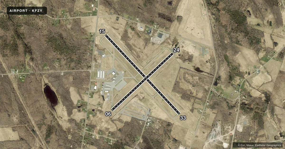
Runways & pattern
Full pagePattern entry · RWY 24
LEFT TRAFFIC| Runway | Heading (°M) | Length | Surface | Traffic |
|---|---|---|---|---|
| 15/33 | 124° / 304° | 5,196 ft | ASPH | Standard L |
| 06/24Favored | 34° / 214° | 3,997 ft | ASPH | Standard L |
Runway end performance
| End | TORA | TODA | ASDA | LDA | VGSI | Approach lights | Obstruction |
|---|---|---|---|---|---|---|---|
| 15 | — | — | — | — | — | — | 51', trees, 340' from thr, 431' R of cntrln, slope 2 |
| 33 | 5,196' | 5,196' | 5,196' | 5,196' | PAPI 4-box left(3.55°) | — | 69', trees, 2195' from thr, 33' R of cntrln, slope 28 |
| 06 | — | — | — | — | — | — | 29', trees, 269' from thr, 242' R of cntrln, slope 2 |
| 24 | — | — | — | — | — | — | 49', pole, 711' from thr, 345' R of cntrln, slope 10 |
Declared distances in feet. TORA = takeoff run available, TODA = takeoff distance, ASDA = accelerate-stop, LDA = landing distance.
Airport sketch
Runways drawn to scale from FAA survey coordinates, rendered over satellite imagery. Not for navigation.
Approaches & charts
ILS · 1
Services on the field
Fuel grades, oxygen, maintenance, ramp storage and lighting — as declared to the FAA by the airport operator.
Fuel & services
- Fuel
- 100LLA
- Oxygen (bottled)
- Not available
- Oxygen (bulk)
- Not available
- Airframe repair
- Major
- Power plant repair
- Major
- Other services
- INSTR,RNTL
Ramp & ground
- Transient storage
- Tie-down
- Hangar
- Landing fee
- No fee published
- Customs
- Not available
- Lighting schedule
- SEE RMK
- Beacon schedule
- SS-SR
- Beacon
- White / Green (civil land)(WG)
- Wind indicator
- Lighted
- Segmented circle
- No
Fuel & FBOs
Cheapest 100LL and Jet A on the field and nearby. Always confirm with the FBO before taxi.
Airport notes
Surface conditions, obstructions, local procedures, lighting outages and other notes published with each FAA cycle.
General notes
- AIRCRAFT DE-ICING AVAILABLE, CONTACT AIRPORT MANAGER AT 315-591-9130.
- ATTENDANCE OTHER HOURS - CALL ARPT MGR.
- DEER AND BIRDS ON OR INVOF ARPT.
- GRASS CUTTING EQUIPMENT OPS ADJACENT TO ALL OPERATIONA SURFACES DALGHT HRS MAY THRU OCT.
- RWY CONDITIONS MAY NOT BE MONITORED OR REPORTED WHEN ARPT IS UNATNDD.
- ULTRLGT ACTIVITY ON AND INVOF ARPT.
- DURING PERIODS OF SNOW REMOVAL OPNS NOV 1 THRU APR 1 ACFT MUST CTC ARPT ON FREQ 123.0 10 MINS PRIOR TO LDG.
- RWY 33 DESIGNATED CALM WIND RWY.
- FOR CD CTC SYRACUSE APCH AT 315-455-6218.
- AVOID VCNTY OF TWR DUE NORTH ON LAKESHORE.
- FQT SEAGULL & CANADA GEESE ACTVT ON AND INVOF ARPT DURG POOR WX PERIODS.
Lighting notes
- HIRL RWY 15/33 & PAPI RWY 33 OPR SS-SR AND PRESET LOW INTST; TO INCR INTST AND ACTVT REIL RWY 15/33; HIRL RWY 15/33; MIRL RWY 06/24; PAPI RWY 33 - CTAF.
Runway surface & condition
- 06/24PCR VALUE: 31/F/B/W/T
- 15/33PCR VALUE: 31/F/B/W/T
Approach & departure obstructions
- 15+14 FT HILL 0-200 FT FM THLD. HILL BEGINS 295 FT LEFT.
- 33+7 FT GND 0-199 FT FM THLD 335 FT RIGHT.
- 0650FT+ HILL 1100FT FM RWY END.
- 15APCH SLP 29:1. 80 FT TREE, 2806 FT FM DTHR; 186 FT RIGHT.
Other notes
- EXISTED PRIOR TO 1959.
- LIGHTED MAIN WIND INDICATOR PLUS LIGHTED INDICATORS AT EACH RUNWAY END.
VFR map & nearby airports
VFR sectional. Tap any ICAO chip to open that airport.
Key facts · KFZY
Answer card- ICAO
- KFZY
- Name
- OSWEGO COUNTY
- Location
- FULTON, NEW YORK
- Elevation
- 475.1 ft MSL
- Traffic pattern altitude
- 1,475.1 ft MSL (1,000 AGL)
- Control tower
- Non-towered (use CTAF)
- Total runways
- 2
- Longest runway
- 15/33 · 5,196 ft
- Published ILS approaches
- 1
- Published frequencies
- 4
- Magnetic variation
- 13°
- Current flight rules
- VFR
- Current wind
- 220° at 5 kt
- Favored runway now
- RWY 24
Oswego County Airport (KFZY) is in Fulton, New York. The field elevation is 475.1 ft MSL. It has two asphalt runways. The longest is 15/33 at 5,196 ft. There is no control tower. CTAF and UNICOM are both 123.0. Syracuse handles approach and departure on 126.125 and 269.125. An ILS is available to runway 33.
Pattern altitude is not published, so use the standard 1,000 ft AGL for light piston operations unless the current Chart Supplement says otherwise. That puts the pattern at about 1,475 ft MSL here. The on-field FBO is Oswego County Airport. It carries 100LL and Jet A Prist. Call 315-591-9130 for current service details.
This field has a few operational points worth planning for. Runway 15/33 has high intensity lighting. Runway 06/24 has medium intensity lighting. The PAPI on runway 33 is controlled by CTAF and runs from sunset to sunrise at low intensity until you call up the lights. The published remarks also call out snow removal coordination from November 1 through April 1. Aircraft should contact the airport on 123.0 ten minutes before landing during those periods. Watch for frequent seagulls and Canada geese in poor weather. There is also a tower due north on the lakeshore that pilots should avoid. Runway 15 has nearby terrain and tree obstructions, so brief that approach carefully before you go in.