METAR & TAF KSDC
Current METAR
Observed 13:35Z
KSDC 271335Z AUTO 25004KT 10SM OVC085 22/18 A2985 RMK AO2
- Wind
- 250° @ 4 kt
- Visibility
- 10 SM
- Temp / Dew
- 22°C / 18°C
- Altimeter
- 29.85 inHg
- Clouds
- OVC
- Density alt
- 1,453 ft
- Ceiling
- 8,500 ft AGL
- Rules
- VFR
Airport info & contacts
Manager on record, flight service, ARTCC, attendance schedule and pattern altitude — published by the FAA and refreshed every 28 days.
Location
- From city
- 3 NM W
- VFR sectional
- DETROIT
- Pattern altitude
- 976 ft AGL · 1,400 ft MSL
- ARTCC
- ZOB · CLEVELAND
- NOTAM facility
- BUF (NOTAM-D)
Airport manager
- Name
- MIKE BJERGA
- Phone
- 315-483-6011
- Address
- PO BOX 148, WILLIAMSON NY 14589
Flight service · Hours
- FSS BUF
- BUFFALO1-800-WX-BRIEF
- Attendance
- MON-FRI · 0830-1700
Frequencies
Tap any row to copy the frequency to your clipboard.
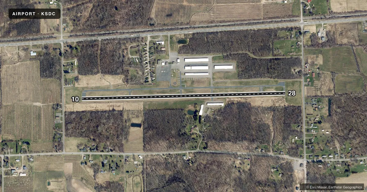
Runways & pattern
Full pagePattern entry · RWY 28
LEFT TRAFFICRunway end performance
| End | TORA | TODA | ASDA | LDA | VGSI | Approach lights | Obstruction |
|---|---|---|---|---|---|---|---|
| 10 | — | — | — | — | PAPI 2-box left(3°) | — | 30', trees, 261' from thr, 177' R of cntrln, slope 2 |
| 28 | — | — | — | — | PAPI 2-box right(3.2°) | — | 70', tree, 401' from thr, 277' R of cntrln, slope 2 |
Declared distances in feet. TORA = takeoff run available, TODA = takeoff distance, ASDA = accelerate-stop, LDA = landing distance.
Airport sketch
Runways drawn to scale from FAA survey coordinates, rendered over satellite imagery. Not for navigation.
Approaches & charts
Services on the field
Fuel grades, oxygen, maintenance, ramp storage and lighting — as declared to the FAA by the airport operator.
Fuel & services
- Fuel
- 100LL
- Oxygen (bottled)
- Not available
- Oxygen (bulk)
- Not available
- Airframe repair
- Major
- Power plant repair
- Major
- Other services
- AMB,INSTR
Ramp & ground
- Transient storage
- Tie-down
- Landing fee
- No fee published
- Customs
- Not available
- Lighting schedule
- SEE RMK
- Beacon schedule
- SS-SR
- Beacon
- White / Green (civil land)(WG)
- Wind indicator
- Lighted
- Segmented circle
- Yes
Fuel & FBOs
Cheapest 100LL and Jet A on the field and nearby. Always confirm with the FBO before taxi.
Airport notes
Surface conditions, obstructions, local procedures, lighting outages and other notes published with each FAA cycle.
General notes
- AREAS OTHER THAN RWY & TWY MAY BE VERY SOFT IN FALL, WINTER & SPRING.
- GEESE & DEER ON & INVOF ARPT.
- FOR CD CTC CLEVELAND ARTCC AT 440-774-0490.
Lighting notes
- ACTIVATE REIL RWY 10 & 28; MIRL RWY 10/28 - CTAF.
Fuel notes
- 100LLCREDIT CARD FUEL AVBL 24 HRS.
Approach & departure obstructions
- 10+8 FT FENCE 131 FT FROM THLD 226 FT L OF CNTLN.
VFR map & nearby airports
VFR sectional. Tap any ICAO chip to open that airport.
Key facts · KSDC
Answer card- ICAO
- KSDC
- Name
- WILLIAMSON/SODUS
- Location
- WILLIAMSON/SODUS, NEW YORK
- Elevation
- 424.3 ft MSL
- Traffic pattern altitude
- 1,400.3 ft MSL (976 AGL)
- Control tower
- Non-towered (use CTAF)
- Total runways
- 1
- Longest runway
- 10/28 · 3,803 ft
- Published ILS approaches
- 0
- Published frequencies
- 4
- Magnetic variation
- 12°
- Current flight rules
- VFR
- Current wind
- 250° at 4 kt
- Favored runway now
- RWY 28
Williamson/Sodus Airport sits in Williamson, New York near Sodus. Field elevation is 424.3 ft MSL. The airport has one runway. Runway 10/28 is 3,803 ft long with asphalt pavement. The field is not towered. Pattern altitude is 976 ft AGL, which is 1,400.3 ft MSL. No ILS approaches are published here, so plan with the current charted procedures and weather minimums in mind.
The on-field FBO is Williamson Flying Club. It carries AVGAS 100LL. Credit card fuel is available 24 hours. The published remarks also matter for a first visit. Areas outside the runway and taxiway can get very soft in fall, winter and spring. There is an 8-foot fence near the runway 10 threshold, offset left of centerline. Geese and deer are reported on and near the airport, so keep a sharp scan on taxi and final. Runway end identifier lights and medium intensity runway lights for runway 10/28 are activated on the CTAF. Clearance delivery is handled through Cleveland ARTCC. Check the current FAA Chart Supplement for any noise or local operating notes before you go.