METAR & TAF 4G1
4G1 does not publish a METAR.
Showing the nearest reporting station: KGKJ (PORT MEADVILLE) · 13.4 NM away. Conditions at 4G1 may differ.
METAR · KGKJ
Observed 10:53Z
KGKJ 271053Z AUTO 23005KT 5SM BR CLR 19/18 A2990 RMK AO2 SLP117 T01890178
- Wind
- 230° @ 5 kt
- Visibility
- 5 SM
- Temp / Dew
- 19°C / 18°C
- Altimeter
- 29.90 inHg
- Clouds
- CLR
- Density alt
- 2,000 ft
- Ceiling
- Unlimited
- Rules
- MVFR
Airport info & contacts
Manager on record, flight service, ARTCC, attendance schedule and pattern altitude — published by the FAA and refreshed every 28 days.
Location
- From city
- 3 NM N
- VFR sectional
- DETROIT
- ARTCC
- ZOB · CLEVELAND
- NOTAM facility
- AOO (NOTAM-D)
Airport manager
- Name
- FRED MURRIN
- Phone
- 724-588-1665
- Address
- 511 E JAMESTOWN RD, GREENVILLE PA 16125
Flight service · Hours
- FSS AOO
- ALTOONA1-800-WX-BRIEF
- Attendance
- MON - SAT · 0900-DUSK
Frequencies
Tap any row to copy the frequency to your clipboard.
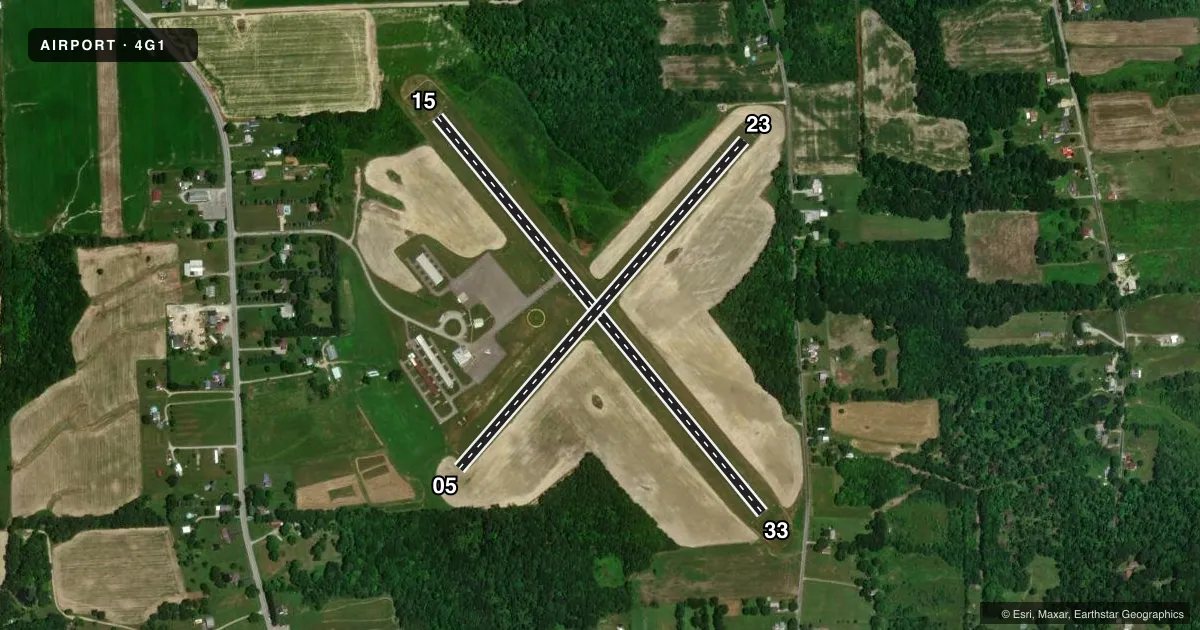
Runways & pattern
Full pagePattern entry · RWY 23
LEFT TRAFFIC| Runway | Heading (°M) | Length | Surface | Traffic |
|---|---|---|---|---|
| 15/33 | 132° / 312° | 3,006 ft | ASPH | Standard L |
| 05/23Favored | 32° / 212° | 2,551 ft | TURF | Standard L |
Runway end performance
| End | TORA | TODA | ASDA | LDA | VGSI | Approach lights | Obstruction |
|---|---|---|---|---|---|---|---|
| 15 | — | — | — | — | PAPI 2-box left(3°) | — | — |
| 33 | — | — | — | — | PAPI 2-box left(3°) | — | 37', trees, 884' from thr, 169' R of cntrln, slope 18 |
| 05 | — | — | — | — | — | — | 64', trees, 353' from thr, 152' R of cntrln, slope 5 |
| 23 | — | — | — | — | — | — | 47', trees, 135' from thr, 118' R of cntrln, slope 2 |
Declared distances in feet. TORA = takeoff run available, TODA = takeoff distance, ASDA = accelerate-stop, LDA = landing distance.
Airport sketch
Runways drawn to scale from FAA survey coordinates, rendered over satellite imagery. Not for navigation.
Approaches & charts
Services on the field
Fuel grades, oxygen, maintenance, ramp storage and lighting — as declared to the FAA by the airport operator.
Fuel & services
- Fuel
- 100LL
- Oxygen (bottled)
- Not available
- Oxygen (bulk)
- Not available
- Airframe repair
- Major
- Power plant repair
- Major
Ramp & ground
- Transient storage
- Tie-down
- Landing fee
- No fee published
- Customs
- Not available
- Lighting schedule
- SEE RMK
- Beacon schedule
- SS-SR
- Beacon
- White / Green (civil land)(WG)
- Wind indicator
- Lighted
- Segmented circle
- Yes
Fuel & FBOs
Cheapest 100LL and Jet A on the field and nearby. Always confirm with the FBO before taxi.
Airport notes
Surface conditions, obstructions, local procedures, lighting outages and other notes published with each FAA cycle.
General notes
- DEER & BIRDS ON & INVOF ARPT.
- PAEW ON & INVOF ARPT.
- FOR CD CTC YOUNGSTOWN APCH AT 330-856-4806, WHEN APCH CLSD CTC CLEVELAND ARTCC AT 440-774-0232.
Lighting notes
- ACTVT MIRL; REIL; PAPI RWY 15/33 - CTAF.
Fuel notes
- 100LLSELF-SVC FUEL AVBL.
Approach & departure obstructions
- 05DSPLCD THLD MKD WITH YELLOW CONES.
- 05RWY 05/23 MKD WITH YELLOW CONES.
Other notes
- VFR USE ONLY
- 1UNATNDD THANKSGIVING, CHRISTMAS, NEW YEARS DAY & SUNDAYS.
- 15/33UNEVEN PAVEMENT 100 FT DOWN RWY 15 & 200 FT DOWN RWY 33.
VFR map & nearby airports
VFR sectional. Tap any ICAO chip to open that airport.
Key facts · 4G1
Answer card- ICAO
- 4G1
- Name
- GREENVILLE MUNI
- Location
- GREENVILLE, PENNSYLVANIA
- Elevation
- 1,206.2 ft MSL
- Traffic pattern altitude
- 2,206.2 ft MSL (1,000 AGL)
- Control tower
- Non-towered (use CTAF)
- Total runways
- 2
- Longest runway
- 15/33 · 3,006 ft
- Published ILS approaches
- 0
- Published frequencies
- 4
- Magnetic variation
- 9°
- Current flight rules
- MVFR
- Current wind
- 230° at 5 kt
- Favored runway now
- RWY 23
Greenville Muni sits in Greenville, Pennsylvania. The field elevation is 1,206.2 ft MSL. It has two runways. The longest is runway 15/33 at 3,006 ft. There is no control tower. Pattern altitude is not published, so use the standard 1,000 ft AGL for light piston traffic unless the current Chart Supplement says otherwise.
No ILS approaches are published here. This is a VFR-only field. CTAF and UNICOM are both 122.8. Youngstown Approach handles the published approach and departure frequencies. If you need clearance delivery, the Chart Supplement lists Youngstown Approach. If that is closed, contact Cleveland ARTCC.
Elbow Street Aviation Services is on the field. It carries 100LL. Self-serve 100LL is also published. Runway 15/33 has medium intensity lights, runway end identifier lights and PAPI for runway 15. Those lights are activated by CTAF. Watch the pavement on 15/33. The Chart Supplement notes uneven pavement 100 feet down runway 15. It also notes uneven pavement 200 feet down runway 33. Runway 05/23 is turf. It has a displaced threshold on runway 05 marked with yellow cones. Deer and birds are also noted in the area, so keep a sharp scan on taxi, takeoff and landing.