METAR & TAF KYNG
Current METAR
Observed 14:51Z
KYNG 271451Z 27006KT 10SM FEW010 BKN150 BKN220 24/21 A2992 RMK AO2 SLP122 T02390211 53003 $
- Wind
- 270° @ 6 kt
- Visibility
- 10 SM
- Temp / Dew
- 24°C / 21°C
- Altimeter
- 29.92 inHg
- Clouds
- BKN
- Density alt
- 2,557 ft
- Ceiling
- 15,000 ft AGL
- Rules
- VFR
Airport info & contacts
Manager on record, flight service, ARTCC, attendance schedule and pattern altitude — published by the FAA and refreshed every 28 days.
Location
- From city
- 10 NM N
- VFR sectional
- DETROIT
- ARTCC
- ZOB · CLEVELAND
- NOTAM facility
- YNG (NOTAM-D)
Airport manager
- Name
- ANTHONY TREVENA
- Phone
- 234-228-9696
- Address
- 1453 YOUNGSTOWN KINGSVILLE RD NE, STE 11, VIENNA OH 44473-9797
Flight service · Hours
- FSS CLE
- CLEVELAND1-800-WX-BRIEF
- Attendance
- ALL
Frequencies
Tap any row to copy the frequency to your clipboard.
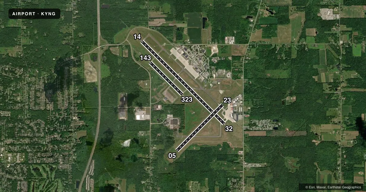
Runways & pattern
Full pagePattern entry · RWY 32
LEFT TRAFFIC| Runway | Heading (°M) | Length | Surface | Traffic |
|---|---|---|---|---|
| 14/32Favored | 127° / 307° | 9,003 ft | ASPH | Standard L |
| 05/23 | 37° / 217° | 5,002 ft | ASPH | Standard L |
| 143/323 | 127° / 307° | 3,501 ft | ASPH | Standard L |
Runway end performance
| End | TORA | TODA | ASDA | LDA | VGSI | Approach lights | Obstruction |
|---|---|---|---|---|---|---|---|
| 14 | 9,003' | 9,003' | 9,003' | 9,003' | PAPI 4-box left(3°) | MALSR | — |
| 32 | 9,003' | 9,003' | 9,003' | 9,003' | PAPI 4-box left(3°) | MALSR | 37', trees, 1689' from thr, 485' R of cntrln, slope 40 |
| 05 | 5,002' | 5,002' | 5,002' | 5,002' | PAPI 4-box right(3.25°) | — | 94', trees, 1749' from thr, 398' R of cntrln, slope 16 |
| 23 | 5,002' | 5,002' | 5,002' | 5,002' | PAPI 4-box right(3°) | — | — |
| 143 | 3,500' | 3,500' | 3,500' | 3,500' | — | — | — |
| 323 | 3,500' | 3,500' | 3,500' | 3,500' | — | — | — |
Declared distances in feet. TORA = takeoff run available, TODA = takeoff distance, ASDA = accelerate-stop, LDA = landing distance.
Airport sketch
Runways drawn to scale from FAA survey coordinates, rendered over satellite imagery. Not for navigation.
Approaches & charts
ILS · 2
Services on the field
Fuel grades, oxygen, maintenance, ramp storage and lighting — as declared to the FAA by the airport operator.
Fuel & services
- Fuel
- 100LLA
- Oxygen (bottled)
- HIGH/LOW
- Oxygen (bulk)
- HIGH/LOW
- Airframe repair
- Major
- Power plant repair
- Major
- Other services
- AFRT,AVNCS,CARGO,CHTR,INSTR,RNTL,SALES
Ramp & ground
- Transient storage
- Tie-down
- Hangar
- Landing fee
- Yes
- Customs
- Not available
- Beacon schedule
- SS-SR
- Beacon
- White / Green (civil land)(WG)
- Wind indicator
- Lighted
- Segmented circle
- No
Fuel & FBOs
Cheapest 100LL and Jet A on the field and nearby. Always confirm with the FBO before taxi.
Airport notes
Surface conditions, obstructions, local procedures, lighting outages and other notes published with each FAA cycle.
General notes
- DEER & BIRD HAZARD. ALL MIL ACFT CTC VADER OPS FOR BIRD WATCH COND.
- RSTD: MIL LANDING ZONE 143*-323* FOR MIL USE ONLY. NO PRACTICE APCH 0300-1300Z++. AFRC ACFT OPR RSTD DUR BIRD WATCH CON MODERATE (TKOF OR LDG PERMS ONLY WHEN DEP AND ARR RTE AVOID IDENT BIRD ACT, NO LCL IFR/VFR TFC PAT ACT) AND SEVERE (TKOF AND LDG PROH WO OG/CC APVL).
- MISC: FBO LINE SVC AVBL 0400-1100Z, OT FONE C330-442-3374.
- MILITARY: AFRC: PPR FOR RAMP AND MIL LZ CTC BASOPS 1230-0400Z++ MON-FRI EXC HOLS (DT 1130-0400Z) AND DURG UNIT TRNG SAT 1300-2200Z++ AND SUN 1200-2100Z++. 48 HRS PN FOR RAMP CTC AFLD MGMT DSN 346-1069/1181, C330-609-1069/1181. AFLD MGMT AND MIL LZ 143/323 OPEN 1230-0400Z++ MON-THU & 1230-0001Z++ FRI, EXC HOLS; 1200-2100Z++ SAT & SUN DURG UNIT TRNG.
- AFRC: NO TRANS ALERT SVC. INBD MIL ACFT INDICATE IN RMK DD FORM 175 WHETHER PRK WILL BE ON CIV OR MIL RAMP. TRANS ACFT RQR MAINT WILL BE RECOVERED BY HOME BASE. ACFT SECURITY NOT AVBL FOR C5 RON EXC EMERG.
- AFRC: MIL LANDING ZONE 323 1.4% DOWNSLOPE. RY 143 1.4% UPSLOPE. SEE FLIP AP/1 SUPPLEMENTARY ARPT RMK.
- FUEL: J8+100(MIL) J8(PN REQ) (NC-100LL,A).
- FLUID: LOX (MIL).
- OIL: O -156
- TERMINAL RAMP AND GENERAL AVIATION PARKING NOT VIS FR THE NW PORTION OF TWY H. MILITARY RAMP FOR MILITARY USE ONLY.
- COMMERCIAL RAMP CLSD TO ALL GA TRAFFIC, COMMERCIAL BOUNDARY AREA DEFINED BY RED SFC PAINTED MARKING.
- AMOPS DOES NOT ISSUE OR STOR COMSEC. LTD COMSEC STOR AVBL AT COMD POST, CTC DSN 346-1315, C330-609-1315 FOR PRIOR COORD.
- FOR CD CTC YOUNGSTOWN APCH AT 330-856-4806, WHEN APCH CLSD CTC CLEVELAND ARTCC AT 440-774-0232/0490.
- AFRC: AIRCREWS - US CSTMS SVC NOT IMMED AVBL. ALL SUPPORT FOR CSTMS MUST BE PRE-COORD AT LEAST 72 HR IN ADVANCE WITH AFLD MGMT
- TWY J ACFT TURN RADIUS RESTRICTION EXISTS FOR ACFT HAVING NOSE GEAR TO MAIN GEAR DIST GREATER THAN 64FT AND MAIN GEAR WID GREATER THAN 30FT
- RSTD: ALL MIL ACFT OPR RSTD DRG BIRD WATCH CONDS, MODERATE (TKOF AND LNDG PMTD ONLY WHEN DEP/ARR RTE AVOID IDENT BIRD ACT, NON LCL IFR/VFR PAT ACT) AND SEVERE (TKOF AND LNDG PROHIBITED WO OG/CC APVL).
- CTN: MIL CONDUCTING NGT VISION DEVICE OPS MON-THU DUSK-0400++.
- MISC: ARFF OPRS IN A RDCD LVL OF SVC STS RGLRLY. CTC FIRE DEPT (DSN 346-1105 OR C330-609-1295) PRIOR TO ARR TO DTRM RISK FACTORS FOR TYPE ACFT.
Runway surface & condition
- 05/23PCR VALUE: 660/F/D/X/T
- 14/32PCR VALUE: 1110/F/D/X/T
- 143/323RWY USED AS A MILITARY ASSAULT STRIP.
Approach & departure obstructions
- 23PAPI UNUSBL BYD 8 DEGS LEFT OF CNTRLN.
- 32PAPI UNUSBL BYD 8 DEGS RIGHT OF CNTRLN.
Other notes
- CLSD TO SKEDD ACR OPS GTR THAN 9 PAX SEATS. 12 HRS PPR FOR UNSKED ACR OPS WITH MORE THAN 30 PAX SEATS CALL ARPT OPS MGR 330-609-5007. ARFF INDEX D AVBL 12 HRS PPR CTC 330-609-1369.
- LNDG FEE FOR ACFT OVER 5000 LBS GWT.
VFR map & nearby airports
VFR sectional. Tap any ICAO chip to open that airport.
Key facts · KYNG
Answer card- ICAO
- KYNG
- Name
- YOUNGSTOWN/WARREN RGNL
- Location
- YOUNGSTOWN/WARREN, OHIO
- Elevation
- 1,191.5 ft MSL
- Traffic pattern altitude
- 2,191.5 ft MSL (1,000 AGL)
- Control tower
- Towered · 24
- Total runways
- 3
- Longest runway
- 14/32 · 9,003 ft
- Published ILS approaches
- 2
- Published frequencies
- 18
- Magnetic variation
- 8°
- Current flight rules
- VFR
- Current wind
- 270° at 6 kt
- Favored runway now
- RWY 32
Youngstown/Warren Rgnl is in Youngstown/Warren, Ohio. The field elevation is 1,191.5 ft MSL. It has three asphalt runways. The longest is runway 14/32 at 9,003 ft. The airport has a control tower. Tower service is listed as 24 hours. Two ILS approaches are published for runway ends 14 and 32.
Pattern altitude is not published in the facts provided. Use the standard 1,000 ft AGL pattern unless the current Chart Supplement or ATC gives you something different. Jets FBO is on the field. It carries 100LL, Jet A and Jet A Prist. If you need fuel or ramp details, call them at (330) 597-0397 before you go.
This is a higher-elevation field with a busy mix of civil and military activity. Read the remarks before arrival. Runway 143/323 is used as a military assault strip. The airport also has restrictions tied to military operations, night vision device work and bird watch conditions. Taxiway J has a turn-radius limit for larger aircraft. If you are planning anything outside a routine piston arrival, check the current FAA Chart Supplement and call the airport operator or the FBO directly for the latest operating picture.