METAR & TAF 7D8
7D8 does not publish a METAR.
Showing the nearest reporting station: KPOV (PORTAGE COUNTY) · 10.9 NM away. Conditions at 7D8 may differ.
METAR · KPOV
Observed 06:15Z
KPOV 270615Z AUTO 00000KT 3SM BR CLR 18/17 A2990 RMK AO2 T01760170
- Wind
- 000° @ 0 kt
- Visibility
- 3 SM
- Temp / Dew
- 18°C / 17°C
- Altimeter
- 29.90 inHg
- Clouds
- CLR
- Density alt
- 1,754 ft
- Ceiling
- Unlimited
- Rules
- MVFR
Airport info & contacts
Manager on record, flight service, ARTCC, attendance schedule and pattern altitude — published by the FAA and refreshed every 28 days.
Location
- From city
- 4 NM N
- VFR sectional
- DETROIT
- ARTCC
- ZOB · CLEVELAND
- NOTAM facility
- CLE (NOTAM-D)
Airport manager
- Name
- ROBERT D GATES
- Phone
- 216-789-9882
- Address
- PO BOX 776, PARKMAN OH 44080-0776
Flight service · Hours
- FSS CLE
- CLEVELAND1-800-WX-BRIEF
- Attendance
- APR-NOV · IREG
Frequencies
Tap any row to copy the frequency to your clipboard.
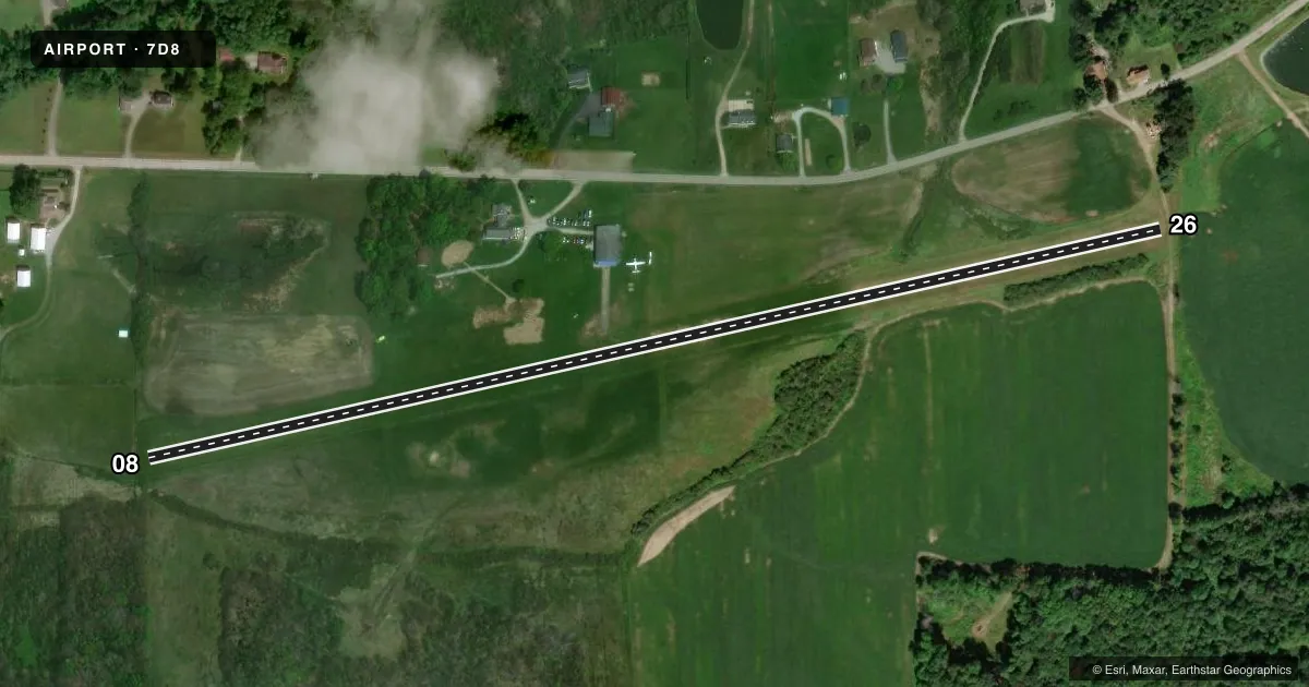
Runways & pattern
Full pagePattern entry · RWY 08
LEFT TRAFFICRunway end performance
| End | TORA | TODA | ASDA | LDA | VGSI | Approach lights | Obstruction |
|---|---|---|---|---|---|---|---|
| 08 | — | — | — | — | — | — | 87', trees, 72' from thr, 119' R of cntrln, slope 0 |
| 26 | — | — | — | — | — | — | 62', trees, 45' from thr, 104' R of cntrln, slope 0 |
Declared distances in feet. TORA = takeoff run available, TODA = takeoff distance, ASDA = accelerate-stop, LDA = landing distance.
Airport sketch
Runways drawn to scale from FAA survey coordinates, rendered over satellite imagery. Not for navigation.
Approaches & charts
Services on the field
Fuel grades, oxygen, maintenance, ramp storage and lighting — as declared to the FAA by the airport operator.
Fuel & services
- Fuel
- Not available
- Other services
- PAJA
Ramp & ground
- Transient storage
- Not published
- Landing fee
- No fee published
- Wind indicator
- Yes
- Segmented circle
- No
Fuel & FBOs
Cheapest 100LL and Jet A on the field and nearby. Always confirm with the FBO before taxi.
Airport notes
Surface conditions, obstructions, local procedures, lighting outages and other notes published with each FAA cycle.
General notes
- SKYDIVING ACT.
- RWY DROPS 10 FT ON EAST END.
- 16 FT HILL/BRUSH STARTING 0 FT FM AER 26.
- FOR CD CTC CLEVELAND APCH AT 216-352-2323
- DEER ON & INVOF ARPT.
Approach & departure obstructions
- 08YELLOW CONES.
- 26YELLOW CONES.
- 08CTLG OBSTN EXCEEDS A 45 DEG SLP.
- 26CTLG OBSTN EXCEEDS A 45 DEG SLP.
Other notes
- VFR ONLY.
- 1PPR NOV THRU APR CTC AMGR CLEVELANDDZ@YAHOO.COM.
- MANAGERARPT PHYS ADS: 15199 GROVE RD, GARRETTSVILLE, OH 44231-9541.
- 08/26ROUGH.
- 08/26PATCHES OF LOOSE GRVL.
VFR map & nearby airports
VFR sectional. Tap any ICAO chip to open that airport.
Key facts · 7D8
Answer card- ICAO
- 7D8
- Name
- GATES
- Location
- GARRETTSVILLE, OHIO
- Elevation
- 1,104 ft MSL
- Traffic pattern altitude
- 2,104 ft MSL (1,000 AGL)
- Control tower
- Non-towered (use CTAF)
- Total runways
- 1
- Longest runway
- 08/26 · 2,800 ft
- Published ILS approaches
- 0
- Published frequencies
- 1
- Magnetic variation
- 7°
- Current flight rules
- MVFR
- Current wind
- 000° at 0 kt
- Favored runway now
- –
GATES is in Garrettsville, Ohio. The field elevation is 1,104 ft MSL. It has one runway, 08/26, which is 2,800 ft long with a turf-gravel surface. The airport is non-towered. CTAF is 122.9. No ILS approaches are published, so plan for VFR only. The published pattern altitude is not listed. Use the standard 1,000 ft AGL pattern unless the current Chart Supplement says otherwise.
This is a rough-field airport. The runway has loose gravel patches. The surface is also described as rough. The east end drops 10 feet. Yellow cones mark the ends of runways 08 and 26. There is also a 16-foot hill and brush starting right at the approach end of runway 26. Deer are present on and near the airport. Skydiving activity also occurs here, so expect extra traffic and keep a sharp lookout.
No on-field FBOs are listed. If you need fuel or ramp details, contact the airport operator or call the field directly before you go. For clearance delivery, Cleveland Approach is listed at 216-352-2323. The airport is VFR only. Pilots planning a winter or shoulder-season trip should also note that prior permission is required from November through April. Check with the airport manager before arrival.