METAR & TAF KPOV
Current METAR
Observed 16:15Z
KPOV 271615Z AUTO 27010KT 10SM CLR 26/21 A2990 RMK AO2 T02570207
- Wind
- 270° @ 10 kt
- Visibility
- 10 SM
- Temp / Dew
- 26°C / 21°C
- Altimeter
- 29.90 inHg
- Clouds
- CLR
- Density alt
- 2,830 ft
- Ceiling
- Unlimited
- Rules
- VFR
Airport info & contacts
Manager on record, flight service, ARTCC, attendance schedule and pattern altitude — published by the FAA and refreshed every 28 days.
Location
- From city
- 3 NM N
- VFR sectional
- DETROIT
- ARTCC
- ZOB · CLEVELAND
- NOTAM facility
- POV (NOTAM-D)
Airport manager
- Name
- ROBERT HARTIGAN
- Phone
- 330-842-6367
- Address
- 4039 NANWAY BLVD, RAVENNA OH 44266-9705
Flight service · Hours
- FSS CLE
- CLEVELAND1-800-WX-BRIEF
- Attendance
- MON-FRI · 0800-1600
Frequencies
Tap any row to copy the frequency to your clipboard.
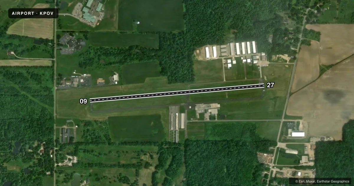
Runways & pattern
Full pagePattern entry · RWY 27
LEFT TRAFFICRunway end performance
| End | TORA | TODA | ASDA | LDA | VGSI | Approach lights | Obstruction |
|---|---|---|---|---|---|---|---|
| 27 | — | — | — | — | PAPI 4-box left(3°) | — | — |
Declared distances in feet. TORA = takeoff run available, TODA = takeoff distance, ASDA = accelerate-stop, LDA = landing distance.
Airport sketch
Runways drawn to scale from FAA survey coordinates, rendered over satellite imagery. Not for navigation.
Approaches & charts
Services on the field
Fuel grades, oxygen, maintenance, ramp storage and lighting — as declared to the FAA by the airport operator.
Fuel & services
- Fuel
- 100LLA+
- Oxygen (bottled)
- HIGH/LOW
- Oxygen (bulk)
- Not available
- Airframe repair
- Major
- Power plant repair
- Major
- Other services
- AMB,INSTR
Ramp & ground
- Transient storage
- Tie-down
- Hangar
- Landing fee
- No fee published
- Customs
- Not available
- Lighting schedule
- SEE RMK
- Beacon schedule
- SS-SR
- Beacon
- White / Green (civil land)(WG)
- Wind indicator
- Lighted
- Segmented circle
- No
Fuel & FBOs
Cheapest 100LL and Jet A on the field and nearby. Always confirm with the FBO before taxi.
Airport notes
Surface conditions, obstructions, local procedures, lighting outages and other notes published with each FAA cycle.
General notes
- DEER ON & INVOF ARPT.
- PARAGLIDER OPS BY PERMIT ONLY.
- FOR CD CTC CLEVELAND APCH AT 216-352-2323, WHEN APCH CLSD CTC CLEVELAND ARTCC AT 440-774-0223/0490.
- FICON NOTAMS UNAVBL AFT HRS, WKENDS, & MAJOR HOLS.
Lighting notes
- ACTVT REIL RWY 09 & 27; PAPI RWY 27; MIRL RWY 09/27 - CTAF.
Fuel notes
- 100LLFUEL AVBL H24 SELF SVC.
Other notes
- PRIOR COORDINATION REQUIRED.
- 1UNATNDD ALL MAJOR HOLS.
- MANAGERARPT PHYS ADS: 4039 NANWAY BLVD, RAVENNA, OH 44266-9705.
- 09/27ALL AREAS OFF RWY SFC SOFT WHEN WET OR THAWING.
VFR map & nearby airports
VFR sectional. Tap any ICAO chip to open that airport.
Key facts · KPOV
Answer card- ICAO
- KPOV
- Name
- PORTAGE COUNTY
- Location
- RAVENNA, OHIO
- Elevation
- 1,197.5 ft MSL
- Traffic pattern altitude
- 2,197.5 ft MSL (1,000 AGL)
- Control tower
- Non-towered (use CTAF)
- Total runways
- 1
- Longest runway
- 09/27 · 3,499 ft
- Published ILS approaches
- 0
- Published frequencies
- 5
- Magnetic variation
- 8°
- Current flight rules
- VFR
- Current wind
- 270° at 10 kt
- Favored runway now
- RWY 27
Portage County Airport sits in Ravenna, Ohio. The field elevation is 1,197.5 ft MSL. It has one runway. Runway 09/27 is 3,499 ft long with asphalt pavement. The airport is non-towered. Traffic uses CTAF 123.05. Pattern altitude is not published, so plan on the standard 1,000 ft AGL for light piston traffic unless the current Chart Supplement says otherwise.
No ILS approaches are published here. For IFR work, check the current approach plates and the current FAA Chart Supplement before departure. Cleveland Approach handles clearance delivery and approach control when active. The published remarks also note that 100LL is available 24 hours a day self-serve. Runway end identifier lights are active on 09 and 27. Medium intensity runway lights are on both runway ends. PAPI is on runway 27.
Portage County Airport is unattended on all major holidays. Deer are reported on and near the airport. The runway surface is one thing to watch, since areas off the pavement can get soft when wet or thawing. The on-field FBO is Portage County Airport. It carries 100LL and Jet A with Prist. If you need transient storage hangar space, get prior coordination first. Paraglider operations are permit only.