METAR & TAF 1G3
1G3 does not publish a METAR.
Showing the nearest reporting station: KAKR (AKRON FULTON INTL) · 7.2 NM away. Conditions at 1G3 may differ.
METAR · KAKR
Observed 11:54Z
KAKR 271154Z AUTO 20005KT 9SM CLR 21/19 A2991 RMK AO2 SLP120 70002 T02060194 10206 20189 52008
- Wind
- 200° @ 5 kt
- Visibility
- 9 SM
- Temp / Dew
- 21°C / 19°C
- Altimeter
- 29.91 inHg
- Clouds
- CLR
- Density alt
- 2,139 ft
- Ceiling
- Unlimited
- Rules
- VFR
Airport info & contacts
Manager on record, flight service, ARTCC, attendance schedule and pattern altitude — published by the FAA and refreshed every 28 days.
Location
- From city
- 3 NM W
- VFR sectional
- DETROIT
- Pattern altitude
- 850 ft AGL · 1,985 ft MSL
- ARTCC
- ZOB · CLEVELAND
- NOTAM facility
- CLE (NOTAM-D)
Airport manager
- Name
- DAVID POLUGA
- Phone
- 330-672-1943
- Address
- 4020 KENT RD, STOW OH 44224-4200
Flight service · Hours
- FSS CLE
- CLEVELAND1-800-WX-BRIEF
- Attendance
- MON-FRI · 0630-DUSK
- SAT-SUN · 0800-DUSK
Frequencies
Tap any row to copy the frequency to your clipboard.
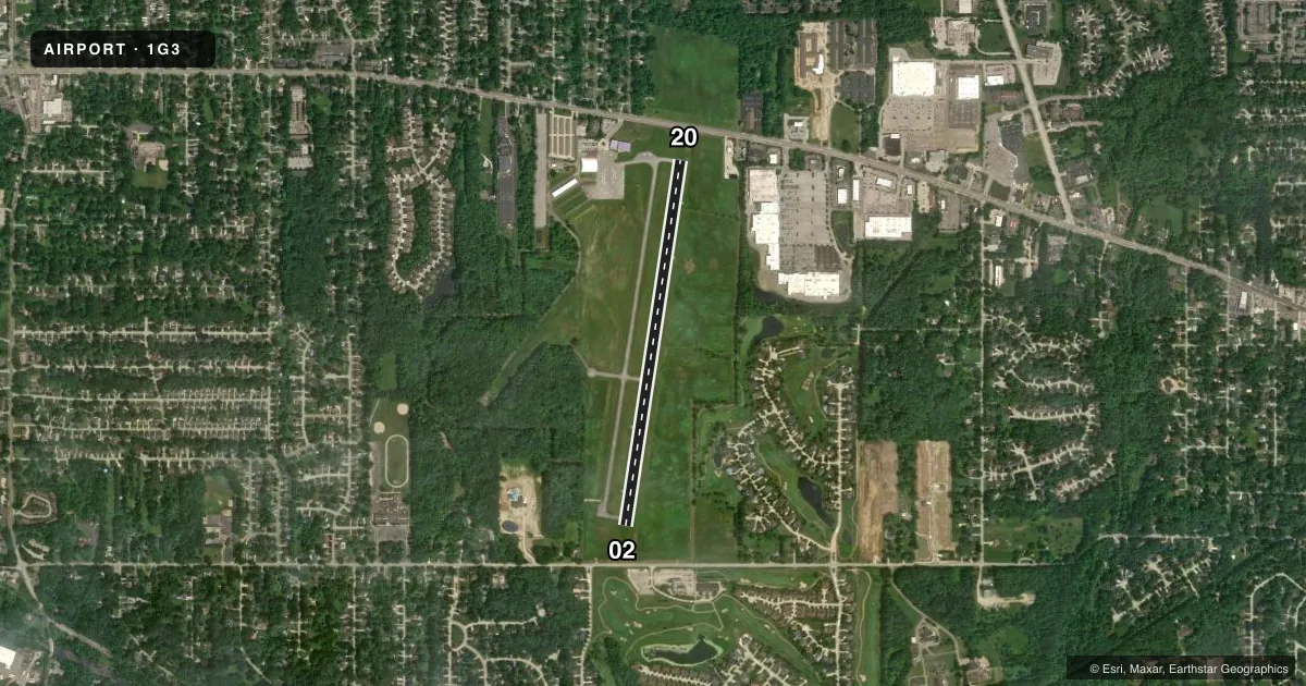
Runways & pattern
Full pagePattern entry · RWY 20
LEFT TRAFFICRunway end performance
| End | TORA | TODA | ASDA | LDA | VGSI | Approach lights | Obstruction |
|---|---|---|---|---|---|---|---|
| 02 | — | — | — | — | VASI 4-box left(3.5°) | — | 125', trees, 1985' from thr, 395' R of cntrln, slope 14 |
| 20 | — | — | — | — | VASI 4-box left(3°) | — | 75', trees, 1650' from thr, 245' R of cntrln, slope 19 |
Declared distances in feet. TORA = takeoff run available, TODA = takeoff distance, ASDA = accelerate-stop, LDA = landing distance.
Airport sketch
Runways drawn to scale from FAA survey coordinates, rendered over satellite imagery. Not for navigation.
Approaches & charts
Services on the field
Fuel grades, oxygen, maintenance, ramp storage and lighting — as declared to the FAA by the airport operator.
Fuel & services
- Fuel
- 100LL
- Airframe repair
- Not available
- Power plant repair
- Not available
- Other services
- INSTR,RNTL
Ramp & ground
- Transient storage
- Tie-down
- Hangar
- Landing fee
- No fee published
- Customs
- Not available
- Lighting schedule
- SEE RMK
- Beacon schedule
- SS-SR
- Beacon
- White / Green (civil land)(WG)
- Wind indicator
- Lighted
- Segmented circle
- No
Fuel & FBOs
Cheapest 100LL and Jet A on the field and nearby. Always confirm with the FBO before taxi.
Airport notes
Surface conditions, obstructions, local procedures, lighting outages and other notes published with each FAA cycle.
General notes
- OCNL DEER, BIRDS, & OTR WILDLIFE ON & INVOF ARPT.
- FOR NOISE ABATEMENT PROCS CALL AMGR.
- FOR CD CTC CLEVELAND APCH AT 216-352-2323, WHEN APCH CLSD CTC CLEVELAND ARTCC AT 440-774-0223/0490.
- HVY STUDENT TRG ACT.
Lighting notes
- ACTVT REIL RWY 02 & 20; VASI RWY 02 & 20; MIRL RWY 02/20 - 122.9.
Fuel notes
- 100LLAVBL ONLY WHEN ATNDD - SELF SVC UNAVBL.
Approach & departure obstructions
- 20CALM WIND RWY.
Other notes
- RAMP FEE FOR MULTI-ENG ACFT - WAIVED WITH FUEL PURCHASE.
- TNST HGR: PPR.
- 1CLSD DEC 25 & JAN 1.
- OWNERAIRPORT@KENT.EDU.
- OWNERADNL INFO: WWW.KENT.EDU/AIRPORT.
VFR map & nearby airports
VFR sectional. Tap any ICAO chip to open that airport.
Key facts · 1G3
Answer card- ICAO
- 1G3
- Name
- KENT STATE UNIVERSITY
- Location
- KENT, OHIO
- Elevation
- 1,134.5 ft MSL
- Traffic pattern altitude
- 1,984.5 ft MSL (850 AGL)
- Control tower
- Non-towered (use CTAF)
- Total runways
- 1
- Longest runway
- 02/20 · 4,000 ft
- Published ILS approaches
- 0
- Published frequencies
- 5
- Magnetic variation
- 7°
- Current flight rules
- VFR
- Current wind
- 200° at 5 kt
- Favored runway now
- RWY 20
Kent State University Airport (1G3) is in Kent, Ohio. The field elevation is 1,134.5 ft MSL. It has one runway, 02/20, which is 4,000 ft long. Runway 20 is the calm wind runway. The airport is non-towered. The published pattern altitude is 850 ft AGL, which is 1,984.5 ft MSL.
There are no published ILS approaches here. For IFR work, plan on Cleveland Approach for clearance delivery and approach services when they are open. If Approach is closed, the remarks direct pilots to Cleveland ARTCC for clearance help. The airport has medium intensity runway lights, REILs on both runway ends and VASI on runways 02 and 20. That helps for night work and for getting set up on final.
Kent State University Airport has one on-field FBO. Kent State University Airport carries AVGAS 100LL. The remarks say 100LL is available only when attended. Self-service is not available. Transient hangar use needs prior permission. Heavy student training activity is published, so expect a busy pattern. Wildlife is also noted in the area. Call the airport manager for noise abatement details before you go.