METAR & TAF 3G3
3G3 does not publish a METAR.
Showing the nearest reporting station: KBJJ (WAYNE COUNTY) · 9.7 NM away. Conditions at 3G3 may differ.
METAR · KBJJ
Observed 18:56Z
KBJJ 251856Z AUTO 20004KT 10SM FEW050 24/14 A3004 RMK AO2 SLP168 T02440144 $
- Wind
- 200° @ 4 kt
- Visibility
- 10 SM
- Temp / Dew
- 24°C / 14°C
- Altimeter
- 30.04 inHg
- Clouds
- FEW
- Density alt
- 2,139 ft
- Ceiling
- Unlimited
- Rules
- VFR
Airport info & contacts
Manager on record, flight service, ARTCC, attendance schedule and pattern altitude — published by the FAA and refreshed every 28 days.
Location
- From city
- 2 NM SW
- VFR sectional
- DETROIT
- ARTCC
- ZOB · CLEVELAND
- NOTAM facility
- CLE (NOTAM-D)
Airport manager
- Name
- QUIENTON REID
- Phone
- 330-334-9861
- Address
- 840 AIRPORT DR, WADSWORTH OH 44281-9552
Flight service · Hours
- FSS CLE
- CLEVELAND1-800-WX-BRIEF
- Attendance
- ALL
Frequencies
Tap any row to copy the frequency to your clipboard.
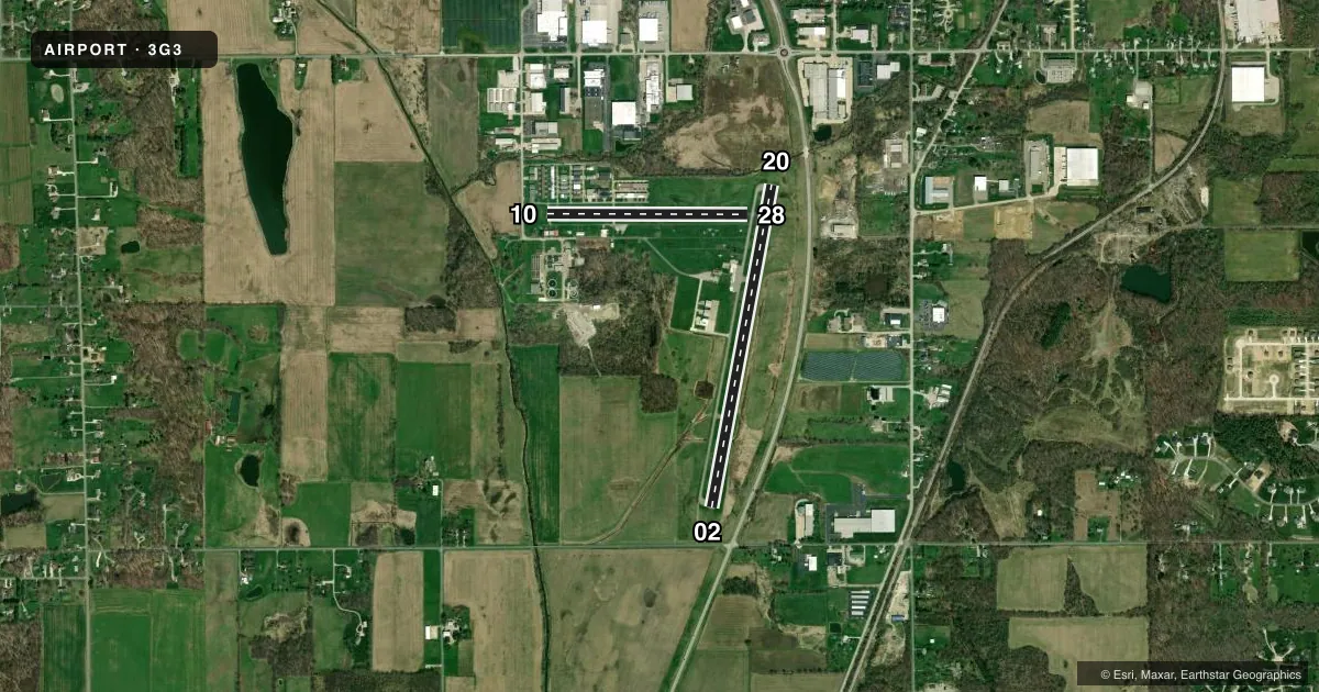
Runways & pattern
Full pagePattern entry · RWY 20
LEFT TRAFFIC| Runway | Heading (°M) | Length | Surface | Traffic |
|---|---|---|---|---|
| 02/20Favored | 4° / 184° | 3,530 ft | ASPH | Standard L |
| 10/28 | 83° / 263° | 2,155 ft | ASPH | Standard L |
Runway end performance
| End | TORA | TODA | ASDA | LDA | VGSI | Approach lights | Obstruction |
|---|---|---|---|---|---|---|---|
| 02 | — | — | — | — | PAPI 2-box left(3°) | — | 4', fence, 201' from thr, 185' R of cntrln, slope 0 |
| 20 | — | — | — | — | PAPI 4-box left(3°) | — | 4', fence, 201' from thr, 235' R of cntrln, slope 0 |
| 10 | — | — | — | — | — | — | 30', pole, 235' from thr, 125' R of cntrln, slope 1 |
| 28 | — | — | — | — | — | — | 26', tree, 655' from thr, 125' R of cntrln, slope 17 |
Declared distances in feet. TORA = takeoff run available, TODA = takeoff distance, ASDA = accelerate-stop, LDA = landing distance.
Airport sketch
Runways drawn to scale from FAA survey coordinates, rendered over satellite imagery. Not for navigation.
Approaches & charts
Services on the field
Fuel grades, oxygen, maintenance, ramp storage and lighting — as declared to the FAA by the airport operator.
Fuel & services
- Fuel
- 100LLAA1+
- Oxygen (bottled)
- Not available
- Oxygen (bulk)
- Not available
- Airframe repair
- Major
- Power plant repair
- Major
- Other services
- CHTR,GLD,INSTR,RNTL,TOW
Ramp & ground
- Transient storage
- Tie-down
- Hangar
- Landing fee
- No fee published
- Customs
- Not available
- Lighting schedule
- SEE RMK
- Beacon schedule
- SS-SR
- Beacon
- White / Green (civil land)(WG)
- Wind indicator
- Lighted
- Segmented circle
- No
Fuel & FBOs
Cheapest 100LL and Jet A on the field and nearby. Always confirm with the FBO before taxi.
Airport notes
Surface conditions, obstructions, local procedures, lighting outages and other notes published with each FAA cycle.
General notes
- RWY 10 CLSD FOR DEPARTURE WHEN WIND LESS THAN 15 KTS FM THE EAST.
- NO LINE OF SIGHT BTN RWY'S 02 & 10.
- RWY 20 CALM WIND RWY BLO 4 KTS FOR NOISE ABATEMENT. AVOID HOSPITAL TO THE N.
- FOR CD CTC CLEVELAND APCH AT 216-352-2323, WHEN APCH CLSD CTC CLEVELAND ARTCC AT 440-774-0223.
- TWY B CLSD TO PWRD ACFT
- BIRDS, DEER, & OTR WILDLIFE ON & INVOF ARPT.
- CAUTION: GLIDER OPS ALL RWY'S
- CAUTION: EXTSV HEL OPS.
- RWY 02 TFC PAT PREFERRED ENTRY AT 45 DEGS TO UPWIND LEG TO AVOID TFC AT 15G ARPT 2.5 NM NW.
Lighting notes
- ACTVT MIRL RWY 02/20 - CTAF. PAPI RWY 02 & 20 OPR CONSLY.
Fuel notes
- AJET A ANTI-ICING AVBL AT NOZZLE.
Approach & departure obstructions
- 02+4 FT FENCE, 200 FT DIST FM THR, 185 FT R, EXTDD TO DTHR, 220 FT R, OBSTN CLNC SLP 0:1.
- 10+20 FT TWY, 0-185 FT DIST, 100 FT L; +20 FT TWY, 0-85 FT DIST, 110 FT R.
- 20+4 FT FENCE, 200 FT DIST, 235 FT L, EXTDD TO 95 FT DIST, 250 FT L, OBSTN CLNC SLP 0:1.
Other notes
- VFR ONLY.
- PRIOR CDN RQRD FOR TSNT HNGR.
- MANAGEROR 330-241-2562.
VFR map & nearby airports
VFR sectional. Tap any ICAO chip to open that airport.
Key facts · 3G3
Answer card- ICAO
- 3G3
- Name
- WADSWORTH MUNI
- Location
- WADSWORTH, OHIO
- Elevation
- 973.7 ft MSL
- Traffic pattern altitude
- 1,973.7 ft MSL (1,000 AGL)
- Control tower
- Non-towered (use CTAF)
- Total runways
- 2
- Longest runway
- 02/20 · 3,530 ft
- Published ILS approaches
- 0
- Published frequencies
- 4
- Magnetic variation
- 7°
- Current flight rules
- VFR
- Current wind
- 200° at 4 kt
- Favored runway now
- RWY 20
Wadsworth Muni sits in Wadsworth, Ohio. The field elevation is 973.7 ft MSL. It has two asphalt runways. Runway 02/20 is the longest at 3,530 ft. Runway 10/28 is 2,155 ft. This is an uncontrolled airport with no tower. The pattern altitude is not published. Use 1,000 ft AGL for light piston traffic unless the current Chart Supplement says otherwise.
There are no ILS approaches published here. Flight Services of Wadsworth is on the field. It carries 100LL, Jet A and Jet A Prist. Jet A with anti-icing is available at the nozzle. The airport is VFR only. That matters if you are planning an arrival in lower weather. Published remarks also call out glider activity on all runways. Wildlife is another factor here. Birds, deer and other animals are reported on and near the airport.
Runway 02 has a preferred pattern entry at a 45-degree angle to the upwind leg. That is meant to help avoid traffic from a nearby airport northwest of the field. Runway 10 is closed for departure when the wind is less than 15 knots from the east. For calm wind, runway 20 is preferred for noise abatement. Avoid the hospital to the north. Check the current Chart Supplement for any published noise or curfew restrictions before flying in.