METAR & TAF 10G
Current METAR
Observed 18:35Z
K10G 271835Z AUTO 20004KT 10SM CLR 27/22 A2984 RMK AO2
- Wind
- 200° @ 4 kt
- Visibility
- 10 SM
- Temp / Dew
- 27°C / 22°C
- Altimeter
- 29.84 inHg
- Clouds
- CLR
- Density alt
- 3,060 ft
- Ceiling
- Unlimited
- Rules
- VFR
Airport info & contacts
Manager on record, flight service, ARTCC, attendance schedule and pattern altitude — published by the FAA and refreshed every 28 days.
Location
- From city
- 2 NM WSW
- VFR sectional
- DETROIT
- ARTCC
- ZID · INDIANAPOLIS
- NOTAM facility
- 10G (NOTAM-D)
Airport manager
- Name
- LARRY CLARK
- Phone
- 330-674-0674
- Address
- 4501 TOWNSHIP ROAD 307, MILLERSBURG OH 44654-9656
Flight service · Hours
- FSS CLE
- CLEVELAND1-800-WX-BRIEF
- Attendance
- MON-FRI · 0800-1700
- SAT · 0900-1700
- SUN · 1200-1700
Frequencies
Tap any row to copy the frequency to your clipboard.
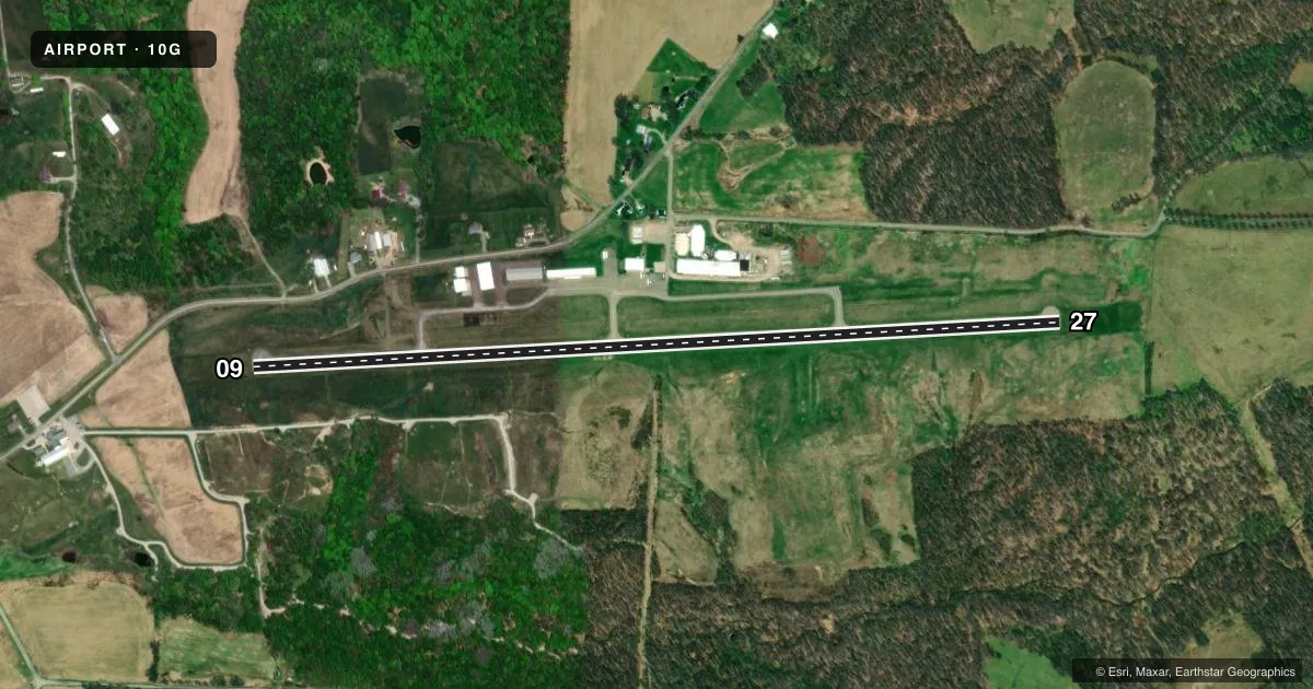
Runways & pattern
Full pagePattern entry · RWY 27
LEFT TRAFFICRunway end performance
| End | TORA | TODA | ASDA | LDA | VGSI | Approach lights | Obstruction |
|---|---|---|---|---|---|---|---|
| 09 | — | — | — | — | — | — | 70', trees, 1550' from thr, 215' R of cntrln, slope 19 |
| 27 | — | — | — | — | PAPI 2-box left(3°) | — | — |
Declared distances in feet. TORA = takeoff run available, TODA = takeoff distance, ASDA = accelerate-stop, LDA = landing distance.
Airport sketch
Runways drawn to scale from FAA survey coordinates, rendered over satellite imagery. Not for navigation.
Approaches & charts
Services on the field
Fuel grades, oxygen, maintenance, ramp storage and lighting — as declared to the FAA by the airport operator.
Fuel & services
- Fuel
- 100LLA
- Oxygen (bottled)
- High pressure
- Oxygen (bulk)
- Not available
- Airframe repair
- Major
- Power plant repair
- Major
- Other services
- INSTR,RNTL
Ramp & ground
- Transient storage
- Tie-down
- Hangar
- Landing fee
- No fee published
- Customs
- Not available
- Lighting schedule
- SEE RMK
- Beacon schedule
- SS-SR
- Beacon
- White / Green (civil land)(WG)
- Wind indicator
- Lighted
- Segmented circle
- No
Fuel & FBOs
Cheapest 100LL and Jet A on the field and nearby. Always confirm with the FBO before taxi.
Airport notes
Surface conditions, obstructions, local procedures, lighting outages and other notes published with each FAA cycle.
General notes
- FOR CD CTC INDIANAPOLIS ARTCC AT 317-247-2411.
- DEER, BIRDS, & OTR WILDLIFE ON & INVOF ARPT.
Lighting notes
- ACTVT REIL RWY 09 & 27; PAPI RWY 27; MIRL RWY 09/27 - 123.4.
Fuel notes
- AANTI-ICING AVBL ON DLVY.
Approach & departure obstructions
- 27CALM WIND RWY.
Other notes
- PRIOR CDN RQRD FOR TSNT HNGR.
- 1EXC MAJOR HOLS.
- MANAGERCELL 330-231-3715.
VFR map & nearby airports
VFR sectional. Tap any ICAO chip to open that airport.
Key facts · 10G
Answer card- ICAO
- 10G
- Name
- HOLMES COUNTY
- Location
- MILLERSBURG, OHIO
- Elevation
- 1,226.5 ft MSL
- Traffic pattern altitude
- 2,226.5 ft MSL (1,000 AGL)
- Control tower
- Non-towered (use CTAF)
- Total runways
- 1
- Longest runway
- 09/27 · 4,400 ft
- Published ILS approaches
- 0
- Published frequencies
- 2
- Magnetic variation
- 8°
- Current flight rules
- VFR
- Current wind
- 200° at 4 kt
- Favored runway now
- RWY 27
Holmes County Airport (10G) sits in Millersburg, Ohio. The field elevation is 1,226.5 ft MSL. It has one runway. Runway 09/27 is 4,400 ft long with an asphalt surface. This is a non-towered field. The published CTAF and UNICOM are both 123.0. No ILS approaches are published here. The pattern altitude is not published. Use the standard 1,000 ft AGL pattern for light piston traffic unless local guidance says otherwise.
Professionals Aviation Company is on the field. It carries AVGAS 100LL, Jet A and Jet A Prist. The airport remarks also note medium intensity runway lights on 09/27. PAPI is on runway 27. REILs are on both runway ends. Prior permission is required. The airport is unattended during major holidays. Deer are reported on and near the airport. Keep a sharp scan on taxi, takeoff and landing. For clearance delivery, contact Indianapolis ARTCC at the published number before departure if you need it. If you are planning a first stop here, verify current airport status with the operator before you go. That is especially smart around holidays or if you need after-hours support.