METAR & TAF KGQQ
KGQQ does not publish a METAR.
Showing the nearest reporting station: KMFD (MANSFIELD LAHM RGNL) · 10.3 NM away. Conditions at KGQQ may differ.
METAR · KMFD
Observed 19:52Z
KMFD 271952Z 23008KT 10SM CLR 28/19 A2986 RMK AO2 SLP100 T02830194 $
- Wind
- 230° @ 8 kt
- Visibility
- 10 SM
- Temp / Dew
- 28°C / 19°C
- Altimeter
- 29.86 inHg
- Clouds
- CLR
- Density alt
- 3,152 ft
- Ceiling
- Unlimited
- Rules
- VFR
Airport info & contacts
Manager on record, flight service, ARTCC, attendance schedule and pattern altitude — published by the FAA and refreshed every 28 days.
Location
- From city
- 3 NM NE
- VFR sectional
- DETROIT
- ARTCC
- ZOB · CLEVELAND
- NOTAM facility
- CLE (NOTAM-D)
Airport manager
- Name
- DR HOLBROOK RILES JR
- Phone
- 419-295-1821
- Address
- 8240 STATE ROUTE 309, GALION OH 44833-9712
Flight service · Hours
- FSS CLE
- CLEVELAND1-800-WX-BRIEF
- Attendance
- MON-FRI · 1000-1700
Frequencies
Tap any row to copy the frequency to your clipboard.
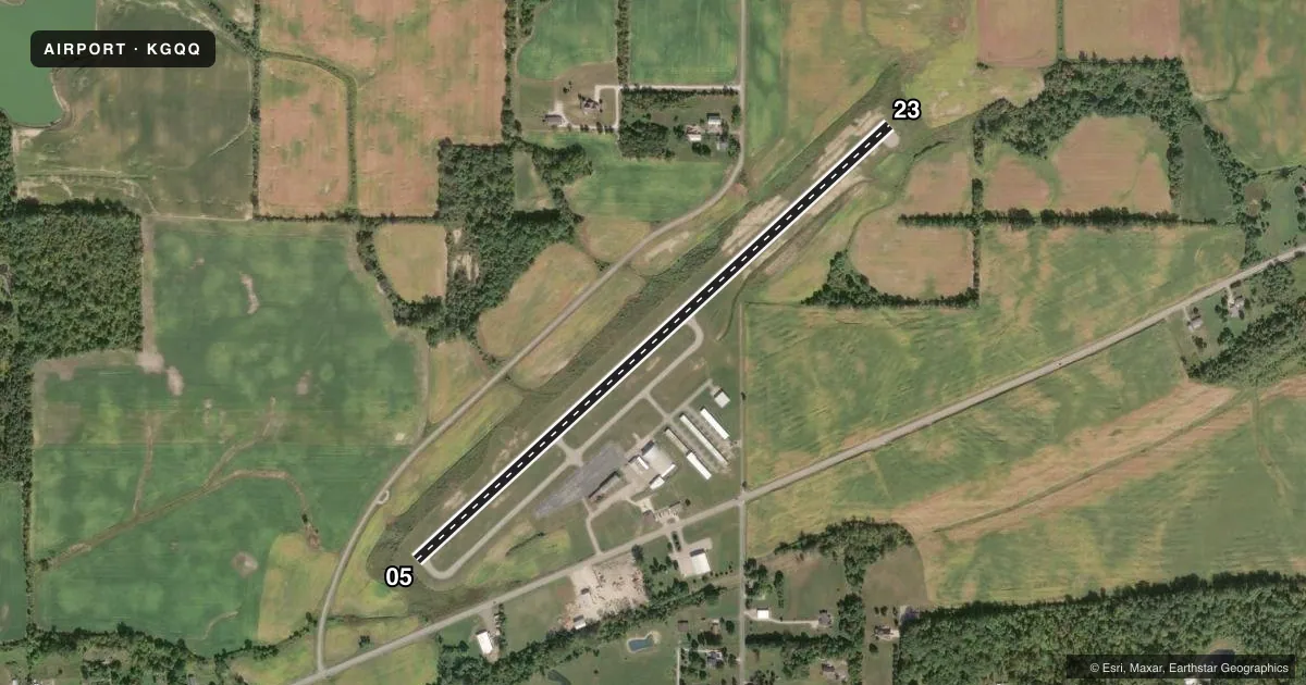
Runways & pattern
Full pagePattern entry · RWY 23
LEFT TRAFFICRunway end performance
| End | TORA | TODA | ASDA | LDA | VGSI | Approach lights | Obstruction |
|---|---|---|---|---|---|---|---|
| 05 | — | — | — | — | PAPI 4-box left(3°) | — | 35', tree, 568' from thr, 103' R of cntrln, slope 10 |
| 23 | — | — | — | — | PAPI 4-box left(3°) | — | 10', crops, 201' from thr, 0' R of cntrln, slope 0 |
Declared distances in feet. TORA = takeoff run available, TODA = takeoff distance, ASDA = accelerate-stop, LDA = landing distance.
Airport sketch
Runways drawn to scale from FAA survey coordinates, rendered over satellite imagery. Not for navigation.
Approaches & charts
Services on the field
Fuel grades, oxygen, maintenance, ramp storage and lighting — as declared to the FAA by the airport operator.
Fuel & services
- Fuel
- 100LLA
- Oxygen (bottled)
- Not available
- Oxygen (bulk)
- Not available
- Airframe repair
- Major
- Power plant repair
- Major
- Other services
- AMB,INSTR,RNTL
Ramp & ground
- Transient storage
- Tie-down
- Hangar
- Landing fee
- No fee published
- Customs
- Not available
- Lighting schedule
- SEE RMK
- Beacon schedule
- SS-SR
- Beacon
- White / Green (civil land)(WG)
- Wind indicator
- Lighted
- Segmented circle
- No
Fuel & FBOs
Cheapest 100LL and Jet A on the field and nearby. Always confirm with the FBO before taxi.
Airport notes
Surface conditions, obstructions, local procedures, lighting outages and other notes published with each FAA cycle.
General notes
- STUDENT TRAINING ACTIVITY.
- FOR CD CTC CLEVELAND APCH AT 216-352-2323, WHEN APCH CLSD CTC CLEVELAND ARTCC AT 440-774-0223/0490.
Lighting notes
- ACTVT REIL RWY 05 & 23; PAPI RWY 05 & 23; MIRL RWY 05/23 - CTAF.
Fuel notes
- 100LL100LL AVBL H24 SELF SVC VIA CREDIT CARD.
- AFOR JET A AFT HRS CALL 419-565-3647.
Approach & departure obstructions
- 23+10 CROPS, 172 FT DIST, 200 FT L/R.
- 05APCH RATIO 18:1 TO DTHR.
- 23CTLG OBSTN EXCEEDS A 45 DEG SLP.
Other notes
- AND CRAWFORD CO.
- MANAGERFBO 419-565-3647.
VFR map & nearby airports
VFR sectional. Tap any ICAO chip to open that airport.
Key facts · KGQQ
Answer card- ICAO
- KGQQ
- Name
- GALION MUNI
- Location
- GALION, OHIO
- Elevation
- 1,224 ft MSL
- Traffic pattern altitude
- 2,224 ft MSL (1,000 AGL)
- Control tower
- Non-towered (use CTAF)
- Total runways
- 1
- Longest runway
- 05/23 · 3,504 ft
- Published ILS approaches
- 0
- Published frequencies
- 5
- Magnetic variation
- 7°
- Current flight rules
- VFR
- Current wind
- 230° at 8 kt
- Favored runway now
- RWY 23
Galion Muni is in Galion, Ohio in Crawford County. The field elevation is 1,224 ft MSL. It has one runway. Runway 05/23 is 3,504 ft long and is the longest runway on the field.
There is no control tower. Use CTAF 122.8 for local traffic. No ILS approaches are published here. Pattern altitude is not published, so plan on the standard 1,000 ft AGL unless the current FAA Chart Supplement says otherwise. The airport uses Cleveland Approach for clearance delivery when needed. If approach is closed, the published remarks point pilots to Cleveland ARTCC for contact.
Galion Municipal Airport is the on-field FBO. It carries 100LL and Jet A. 100LL is available 24 hours a day self-service by credit card. Jet A after hours requires a phone call, so verify the current procedure before you go. The published remarks also note student training activity. That matters here because traffic can build up around the pattern.
There are a few items to brief before arrival. Runway 23 has a cataloged obstruction issue near the approach path. The published remarks also mention crops near the runway 23 side. Runway end identifier lights, PAPI and medium intensity runway lights are installed on 05/23. Check the current FAA Chart Supplement for any noise or curfew restrictions before flying into the field.