METAR & TAF KLNN
Current METAR
Observed 19:35Z
KLNN 241935Z AUTO 03006KT 10SM CLR 22/10 A3007 RMK AO1 T02180096
- Wind
- 030° @ 6 kt
- Visibility
- 10 SM
- Temp / Dew
- 22°C / 10°C
- Altimeter
- 30.07 inHg
- Clouds
- CLR
- Density alt
- 1,430 ft
- Ceiling
- Unlimited
- Rules
- VFR
Airport info & contacts
Manager on record, flight service, ARTCC, attendance schedule and pattern altitude — published by the FAA and refreshed every 28 days.
Location
- From city
- 3 NM N
- VFR sectional
- DETROIT
- ARTCC
- ZOB · CLEVELAND
- NOTAM facility
- LNN (NOTAM-D)
Airport manager
- Name
- PATRICK T MOHORCIC
- Phone
- 440-350-5343
- Address
- 105 MAIN ST STE B-501, PAINESVILLE OH 44077-3414
Flight service · Hours
- FSS CLE
- CLEVELAND1-800-WX-BRIEF
- Attendance
- 0700-2100
Frequencies
Tap any row to copy the frequency to your clipboard.
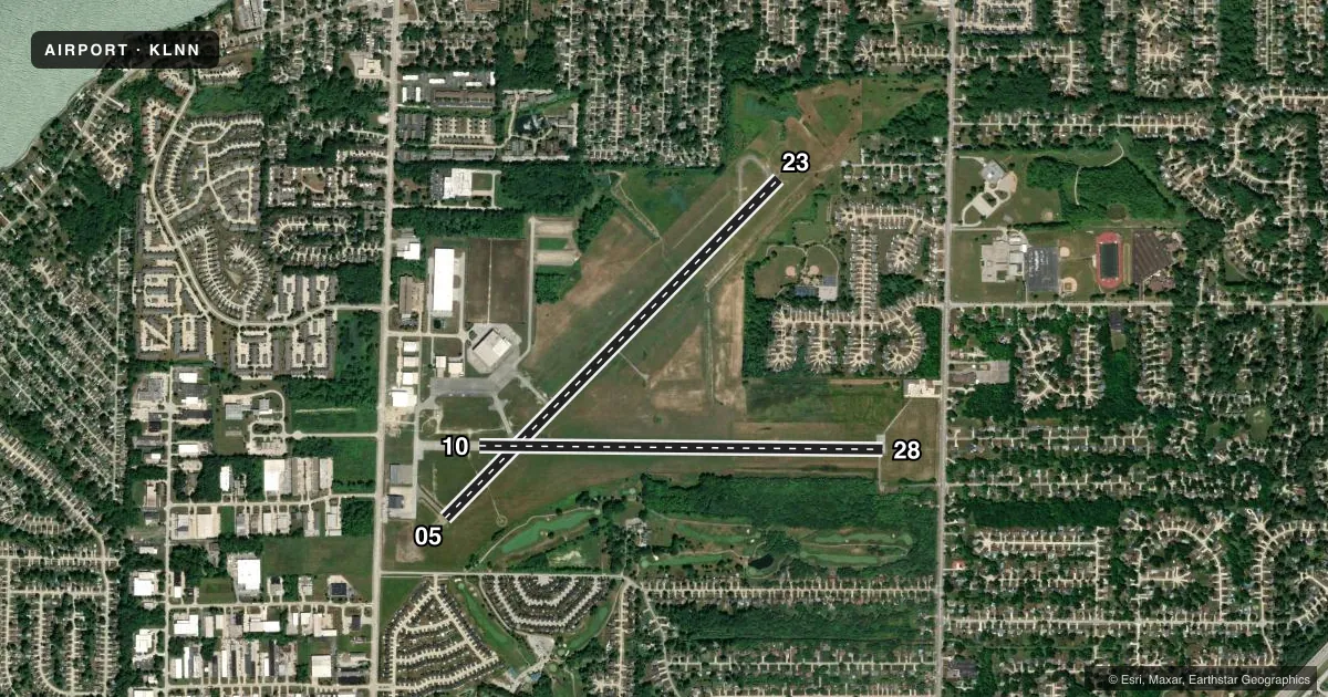
Runways & pattern
Full pagePattern entry · RWY 05
LEFT TRAFFIC| Runway | Heading (°M) | Length | Surface | Traffic |
|---|---|---|---|---|
| 05/23Favored | 37° / 217° | 5,028 ft | ASPH | Standard L |
| 10/28 | 83° / 263° | 4,272 ft | ASPH | Standard L |
Runway end performance
| End | TORA | TODA | ASDA | LDA | VGSI | Approach lights | Obstruction |
|---|---|---|---|---|---|---|---|
| 05 | — | — | — | — | PAPI 4-box left(3.5°) | — | 62', tree, 1399' from thr, 157' R of cntrln, slope 19 |
| 23 | — | — | — | — | PAPI 4-box left(4°) | — | 98', trees, 1335' from thr, 341' R of cntrln, slope 11 |
| 10 | — | — | — | — | PAPI 2-box left(3.5°) | — | — |
| 28 | — | — | — | — | PAPI 2-box left(3.5°) | — | 68', trees, 738' from thr, 215' R of cntrln, slope 7 |
Declared distances in feet. TORA = takeoff run available, TODA = takeoff distance, ASDA = accelerate-stop, LDA = landing distance.
Airport sketch
Runways drawn to scale from FAA survey coordinates, rendered over satellite imagery. Not for navigation.
Approaches & charts
Services on the field
Fuel grades, oxygen, maintenance, ramp storage and lighting — as declared to the FAA by the airport operator.
Fuel & services
- Fuel
- 100LLA
- Oxygen (bottled)
- Not available
- Oxygen (bulk)
- HIGH/LOW
- Airframe repair
- Major
- Power plant repair
- Major
- Other services
- CHTR,INSTR,RNTL
Ramp & ground
- Transient storage
- Tie-down
- Hangar
- Landing fee
- Yes
- Customs
- Not available
- Lighting schedule
- SEE RMK
- Beacon schedule
- SS-SR
- Beacon
- White / Green (civil land)(WG)
- Wind indicator
- Lighted
- Segmented circle
- Yes
Fuel & FBOs
Cheapest 100LL and Jet A on the field and nearby. Always confirm with the FBO before taxi.
Airport notes
Surface conditions, obstructions, local procedures, lighting outages and other notes published with each FAA cycle.
General notes
- DEER, BIRDS, & OTR WILDLIFE ON & INVOF ARPT.
- PAT WORK NA 2300-0800.
- FOR CD CTC CLEVELAND APCH AT 216-352-2323.
Lighting notes
- ACTVT REIL RWY 05, 23, 10, & 28; MIRL RWY 05/23 & 10/28 - CTAF. PAPI RWY 05, 23, 10, & 28 OPR CONSLY.
Approach & departure obstructions
- 05APCH SLP 24:1 TO DTHR OVR +98 FT TREE, 2372 FT DIST, 548 FT L.
- 28APCH SLP 10:1 TO DTHR OVR +89 FT TREES, 931 FT DIST, 329 FT L.
Other notes
- LDG FEE FOR ALL COML ACFT BY WEIGHT; MULTI-ENG & LRGR.
- 1FOR ATTENDANT OR FUEL SER AFT HRS CALL 440-942-7092, 2300-0600 BY PRIOR ARNGMT ONLY.
- MANAGERARPT PHYS ADS: 38550 JET CENTER DR, WILLOUGHBY, OH 44094-8174.
- MANAGERCELL 440-321-9036.
VFR map & nearby airports
VFR sectional. Tap any ICAO chip to open that airport.
Key facts · KLNN
Answer card- ICAO
- KLNN
- Name
- LAKE COUNTY EXEC
- Location
- WILLOUGHBY, OHIO
- Elevation
- 625.6 ft MSL
- Traffic pattern altitude
- 1,625.6 ft MSL (1,000 AGL)
- Control tower
- Non-towered (use CTAF)
- Total runways
- 2
- Longest runway
- 05/23 · 5,028 ft
- Published ILS approaches
- 0
- Published frequencies
- 4
- Magnetic variation
- 8°
- Current flight rules
- VFR
- Current wind
- 030° at 6 kt
- Favored runway now
- RWY 05
Lake County Exec Airport is in Willoughby, Ohio. The field elevation is 625.6 ft MSL. It has two asphalt runways. The longest is 5,028 ft on runway 05/23. There is no control tower. Cleveland Approach handles IFR services on 125.35 and 346.325. CTAF and UNICOM are both 122.725.
No ILS approaches are published here. Pattern altitude is not published in the facts. For light piston traffic, use the standard 1,000 ft AGL pattern unless the current Chart Supplement says otherwise. The published remarks also show runway end identifier lights on 05, 23, 10 and 28. Medium intensity runway lights are on both runways and are CTAF controlled. PAPI is listed on all four runway ends.
Classic Jet Center is on the field. It carries 100LL, Jet A and Jet A Prist. After hours attendant or fuel service is by prior arrangement only. Pattern work is not authorized between 2300 and 0800. Watch for deer, birds and other wildlife in the area. Runway 28 has a published obstacle note with trees near the displaced threshold. Runway 05 also has a tree note near the approach path. If you are planning a commercial or multi-engine arrival, note that a landing fee applies by weight. For clearance delivery, contact Cleveland Approach.