METAR & TAF 7D9
7D9 does not publish a METAR.
Showing the nearest reporting station: KHZY (NORTHEAST OHIO RGNL) · 9.3 NM away. Conditions at 7D9 may differ.
METAR · KHZY
Observed 06:53Z
KHZY 120653Z AUTO 18007KT 10SM FEW060 24/22 A2977 RMK AO2 LTG DSNT W SLP073 T02390217
- Wind
- 180° @ 7 kt
- Visibility
- 10 SM
- Temp / Dew
- 24°C / 22°C
- Altimeter
- 29.77 inHg
- Clouds
- FEW
- Density alt
- 2,283 ft
- Ceiling
- Unlimited
- Rules
- VFR
Airport info & contacts
Manager on record, flight service, ARTCC, attendance schedule and pattern altitude — published by the FAA and refreshed every 28 days.
Location
- From city
- 3 NM SE
- VFR sectional
- DETROIT
- ARTCC
- ZOB · CLEVELAND
- NOTAM facility
- CLE (NOTAM-D)
Airport manager
- Name
- JOHN "JAY" WILLIAMS JR
- Phone
- 440-813-7494
- Address
- 1100 S COUNTY LINE RD, GENEVA OH 44041-9311
Flight service · Hours
- FSS CLE
- CLEVELAND1-800-WX-BRIEF
- Attendance
- Unattended
Frequencies
Tap any row to copy the frequency to your clipboard.
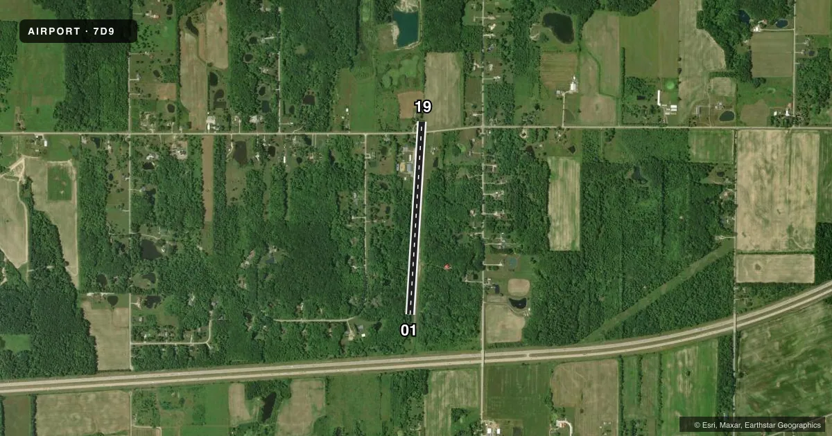
Runways & pattern
Full pagePattern entry · RWY 19
LEFT TRAFFICRunway end performance
| End | TORA | TODA | ASDA | LDA | VGSI | Approach lights | Obstruction |
|---|---|---|---|---|---|---|---|
| 01 | — | — | — | — | — | — | 50', tree, 224' from thr, 63' R of cntrln, slope 0 |
| 19 | — | — | — | — | — | — | 80', trees, 201' from thr, 50' R of cntrln, slope 0 |
Declared distances in feet. TORA = takeoff run available, TODA = takeoff distance, ASDA = accelerate-stop, LDA = landing distance.
Airport sketch
Runways drawn to scale from FAA survey coordinates, rendered over satellite imagery. Not for navigation.
Approaches & charts
Services on the field
Fuel grades, oxygen, maintenance, ramp storage and lighting — as declared to the FAA by the airport operator.
Fuel & services
- Fuel
- Not available
- Oxygen (bottled)
- Not available
- Oxygen (bulk)
- Not available
- Airframe repair
- Not available
- Power plant repair
- Not available
Ramp & ground
- Transient storage
- Not published
- Landing fee
- No fee published
- Customs
- Not available
- Lighting schedule
- SS-SR
- Wind indicator
- Yes
- Segmented circle
- No
Fuel & FBOs
Cheapest 100LL and Jet A on the field and nearby. Always confirm with the FBO before taxi.
Airport notes
Surface conditions, obstructions, local procedures, lighting outages and other notes published with each FAA cycle.
General notes
- DEER ON & INVOF ARPT.
- NO LINE OF SIGHT BTN RWY ENDS.
- FOR CD CTC BUFFALO APCH AT 716-626-6920, WHEN APCH CLSD CTC CLEVELAND ARTCC AT 440-774-0232/0490.
- RWY 19: 15 FT ROAD, 32 FT FM RWY END.
- 70 FT TREES ALG BOTH SIDES OF RWY 01/19.
- ACFT PARKED WI RESA, AER 19, 33 FT RIGHT OF CNTRLN.
- NGT OPS PROHIBITED.
Runway surface & condition
- 01/19NSTD LIRL DUE TO SPACING; MULT LGTS DOWN OR MISG.
Approach & departure obstructions
- 0170 FT TREES, 0-200 FT DIST, 125 FT L/R.
- 1915 FT ROAD, 32 FT DIST; 35 FT PLINE, 70 FT DIST, 0 FT B; GRADE CHGS & 78 FT TREES, 162 FT DIST, 15 FT R; 35 FT TREE, 30 FT DIST, 30 FT L.
- 01FADED.
- 19FADED.
- 01NSTD BASIC DUE TO SPACING & SIZE.
- 19NSTD BASIC DUE TO SPACING & SIZE.
- 01CTLG OBSTN EXCEEDS A 45 DEG SLP.
- 19CTLG OBSTN EXCEEDS A 45 DEG SLP.
- 19+35 FT PLINE; +78 FT TREES, NORTH OF ROAD.
Other notes
- VFR OPS ONLY.
- 01/19RWY SFC HIGHLY DETERIORATED; ROUGH PAVEMENT & UNEVEN ROLLING TRRN; WDSPR SVR CRACKING; LOOSE AGGREGATE & FOD.
VFR map & nearby airports
VFR sectional. Tap any ICAO chip to open that airport.
Key facts · 7D9
Answer card- ICAO
- 7D9
- Name
- GERMACK
- Location
- GENEVA, OHIO
- Elevation
- 820 ft MSL
- Traffic pattern altitude
- 1,820 ft MSL (1,000 AGL)
- Control tower
- Non-towered (use CTAF)
- Total runways
- 1
- Longest runway
- 01/19 · 3,260 ft
- Published ILS approaches
- 0
- Published frequencies
- 1
- Magnetic variation
- 7°
- Current flight rules
- VFR
- Current wind
- 180° at 7 kt
- Favored runway now
- RWY 19
GERMACK (7D9) sits in Geneva, Ohio. Field elevation is 820 ft MSL. The airport has one runway. Runway 01/19 is 3,260 ft long with an asphalt surface. There is no control tower. CTAF is 122.9. No ILS approaches are published here.
The pattern altitude is not published. Use 1,000 ft AGL for light piston operations unless the current FAA Chart Supplement says otherwise. This field has a lot of published runway concerns. The runway surface is described as highly deteriorated. It has rough pavement, uneven rolling terrain, severe cracking, loose aggregate and foreign object debris. There are also nonstandard basic markings on both ends. Markings on runway 01 are faded. Obstructions are close in at both ends. Runway 01 has trees near the departure end. Runway 19 has a road, power line and trees near the threshold area. If you are planning a first visit, treat this as a short-field, high-caution stop and verify current conditions before you go. There is no on-field FBO listed, so call the airport operator directly or contact the field by phone for current services before arrival.