METAR & TAF KHZY
Current METAR
Observed 14:53Z
KHZY 121453Z AUTO 29013G22KT 10SM BKN017 BKN028 OVC033 23/18 A2985 RMK AO2 RAE1359 SLP102 P0000 60000 T02280183 51022
- Wind
- 290° @ 13G22 kt
- Visibility
- 10 SM
- Temp / Dew
- 23°C / 18°C
- Altimeter
- 29.85 inHg
- Clouds
- OVC
- Density alt
- 2,195 ft
- Ceiling
- 1,700 ft AGL
- Rules
- MVFR
Airport info & contacts
Manager on record, flight service, ARTCC, attendance schedule and pattern altitude — published by the FAA and refreshed every 28 days.
Location
- From city
- 8 NM SE
- VFR sectional
- DETROIT
- ARTCC
- ZOB · CLEVELAND
- NOTAM facility
- HZY (NOTAM-D)
Airport manager
- Name
- LANCE BUSHWEILER
- Phone
- 440-576-9271
- Address
- PO BOX 379, JEFFERSON OH 44047-0379
Flight service · Hours
- FSS CLE
- CLEVELAND1-800-WX-BRIEF
- Attendance
- MON-FRI · 0800-1700
- SAT-SUN · ON CALL
Frequencies
Tap any row to copy the frequency to your clipboard.
Runways & pattern
Full pagePattern entry · RWY 27
LEFT TRAFFICRunway end performance
| End | TORA | TODA | ASDA | LDA | VGSI | Approach lights | Obstruction |
|---|---|---|---|---|---|---|---|
| 09 | 5,900' | 5,900' | 5,100' | 5,100' | PAPI 4-box left(3°) | — | — |
| 27 | 5,900' | 5,900' | 5,500' | 5,100' | PAPI 4-box left(3°) | — | — |
Declared distances in feet. TORA = takeoff run available, TODA = takeoff distance, ASDA = accelerate-stop, LDA = landing distance.
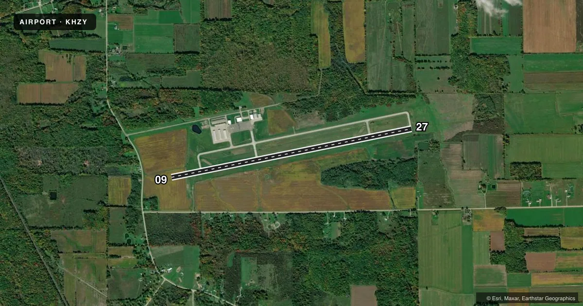
Airport sketch
Runways drawn to scale from FAA survey coordinates, rendered over satellite imagery. Not for navigation.
Approaches & charts
Services on the field
Fuel grades, oxygen, maintenance, ramp storage and lighting — as declared to the FAA by the airport operator.
Fuel & services
- Fuel
- 100LLA+
- Oxygen (bottled)
- Not available
- Oxygen (bulk)
- Not available
- Airframe repair
- Not available
- Power plant repair
- Not available
- Other services
- INSTR,RNTL
Ramp & ground
- Transient storage
- Tie-down
- Hangar
- Landing fee
- No fee published
- Customs
- Not available
- Lighting schedule
- SEE RMK
- Beacon schedule
- SS-SR
- Beacon
- White / Green (civil land)(WG)
- Wind indicator
- Lighted
- Segmented circle
- No
Fuel & FBOs
Cheapest 100LL and Jet A on the field and nearby. Always confirm with the FBO before taxi.
Airport notes
Surface conditions, obstructions, local procedures, lighting outages and other notes published with each FAA cycle.
General notes
- SER: ACFT DEICE - TYPE 1 & 4 FLUID, LAV CART, & GPU AVBL.
- FOR CD CTC BUFFALO APCH AT 716-626-6920, WHEN APCH CLSD CTC CLEVELAND ARTCC AT 440-774-0232.
- FLD CONDS UNMON AFT BUS HRS.
- DEER & BIRDS INVOF ARPT.
- SNOW REMOVAL OPS DRG ATNDD HRS, MAY BE LTD HOLS & WKENDS.
Lighting notes
- ACTVT REIL RWY 09 & 27; HIRL RWY 09/27 - 123.3. PAPI RWY 09 & 27 OPR CONSLY.
Fuel notes
- 100LL100LL AVBL H24 SELF SVC VIA CREDIT CARD.
Other notes
- THIS AIRPORT HAS BEEN SURVEYED BY THE NATIONAL GEODETIC SURVEY.
- RAMP FEE FOR TURBINE ACFT.
- PISTON ACFT MUST TIEDOWN USING APN ANCHOR POINTS WHEN UNATNDD - CALL FOR DTLS.
- 3UNATNDD CHRISTMAS & NEW YEARS DAY.
- 4FEE FOR SER AFT HRS & WKENDS CALL AHD 440-855-1126.
- MANAGERARPT PHYS ADS: 2382 AIRPORT RD, JEFFERSON, OH 44047-9491.
VFR map & nearby airports
VFR sectional. Tap any ICAO chip to open that airport.
Key facts · KHZY
Answer card- ICAO
- KHZY
- Name
- NORTHEAST OHIO RGNL
- Location
- ASHTABULA, OHIO
- Elevation
- 926 ft MSL
- Traffic pattern altitude
- 1,926 ft MSL (1,000 AGL)
- Control tower
- Non-towered (use CTAF)
- Total runways
- 1
- Longest runway
- 09/27 · 5,900 ft
- Published ILS approaches
- 0
- Published frequencies
- 3
- Magnetic variation
- 9°
- Current flight rules
- MVFR
- Current wind
- 290° at 13 kt
- Favored runway now
- RWY 27
Northeast Ohio Rgnl is in Ashtabula, Ohio. The field elevation is 926 ft MSL. It has one runway. Runway 09/27 is 5,900 ft long with an asphalt surface. There is no control tower. The published traffic pattern altitude is not listed, so use the current FAA Chart Supplement before you fly. No ILS approaches are published here.
The on-field FBO is Northeast Ohio Regional Airport. It carries 100LL and Jet A Prist. Call (440) 576-9271 for current service details. The published remarks also note deer and birds in the area. Field conditions are unmonitored after business hours. Piston aircraft must be tied down using apron anchor points when unattended. Call ahead for details.
Lighting is useful to know here. Runway end identifier lights are active on 09 and 27. High intensity runway lights are on 09/27 and are controlled on frequency 123.3. Precision approach path indicators on both runway ends operate continuously. For IFR work, Buffalo Approach handles clearance delivery at 716-626-6920. When approach is closed, contact Cleveland ARTCC at 440-774-0232. This is a good field to brief carefully if you are new to the area. Watch for wildlife. Check current runway and service status before arrival, especially after hours or on holidays.