METAR & TAF KLCK
Current METAR
Observed 16:55Z
KLCK 271655Z AUTO 24004KT 10SM CLR 28/21 A2991 RMK AO2 T02810209
- Wind
- 240° @ 4 kt
- Visibility
- 10 SM
- Temp / Dew
- 28°C / 21°C
- Altimeter
- 29.91 inHg
- Clouds
- CLR
- Density alt
- 2,495 ft
- Ceiling
- Unlimited
- Rules
- VFR
Airport info & contacts
Manager on record, flight service, ARTCC, attendance schedule and pattern altitude — published by the FAA and refreshed every 28 days.
Location
- From city
- 10 NM S
- VFR sectional
- CINCINNATI
- ARTCC
- ZID · INDIANAPOLIS
- NOTAM facility
- LCK (NOTAM-D)
Airport manager
- Name
- DAREN A GRIFFIN
- Phone
- 614-239-4000
- Address
- 7250 STAR CHECK DR, COLUMBUS OH 43217-1025
Flight service · Hours
- FSS DAY
- DAYTON1-800-WX-BRIEF
- Attendance
- ALL
Frequencies
Tap any row to copy the frequency to your clipboard.
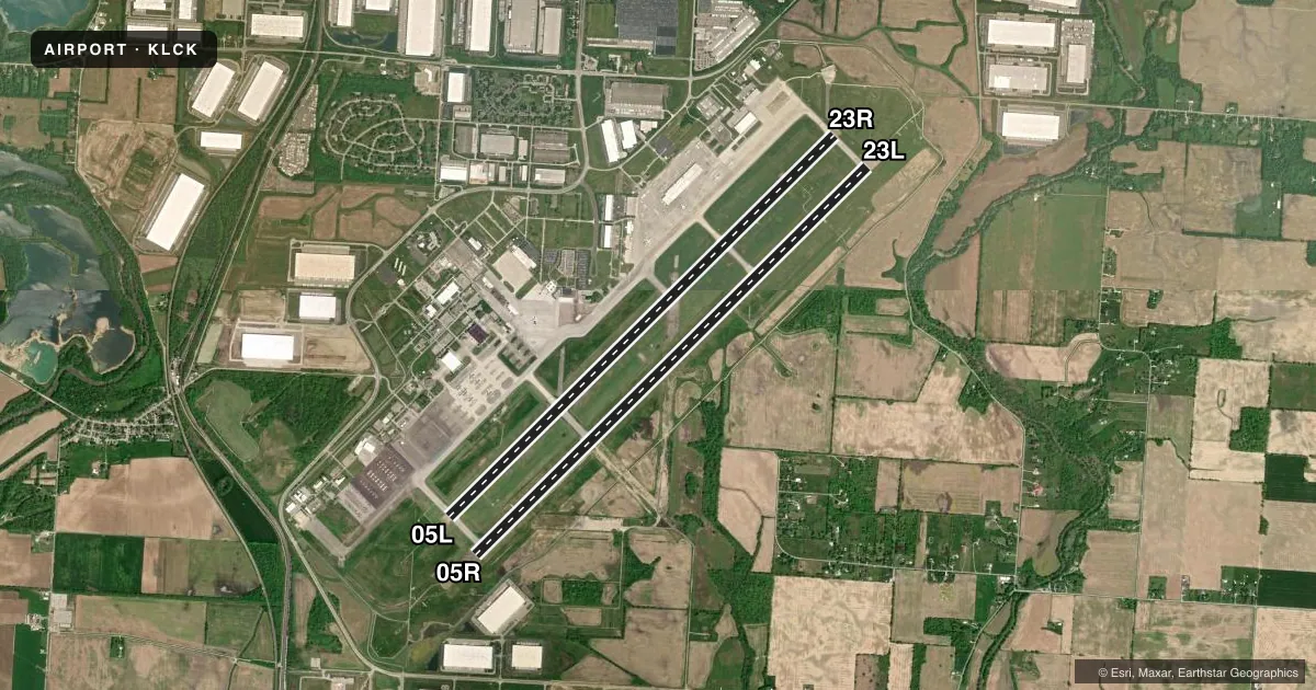
Runways & pattern
Full pagePattern entry · RWY 23L
LEFT TRAFFIC| Runway | Heading (°M) | Length | Surface | Traffic |
|---|---|---|---|---|
| 05R/23LFavored | 38° / 218° | 12,103 ft | ASPH-CONC | Standard L |
| 05L/23R | 38° / 218° | 11,902 ft | ASPH | Standard L |
Runway end performance
| End | TORA | TODA | ASDA | LDA | VGSI | Approach lights | Obstruction |
|---|---|---|---|---|---|---|---|
| 05R | 12,103' | 12,103' | 12,103' | 12,103' | PAPI 4-box left(3°) | ALSF2 | — |
| 23L | 12,103' | 12,103' | 12,103' | 12,103' | PAPI 4-box left(3°) | MALSR | — |
| 05L | 11,902' | 11,902' | 11,902' | 11,004' | PAPI 4-box left(3°) | MALSR | — |
| 23R | 11,902' | 11,902' | 11,902' | 10,913' | PAPI 4-box left(3°) | — | — |
Declared distances in feet. TORA = takeoff run available, TODA = takeoff distance, ASDA = accelerate-stop, LDA = landing distance.
Airport sketch
Runways drawn to scale from FAA survey coordinates, rendered over satellite imagery. Not for navigation.
Approaches & charts
ILS · 3
Services on the field
Fuel grades, oxygen, maintenance, ramp storage and lighting — as declared to the FAA by the airport operator.
Fuel & services
- Fuel
- 100LLAA++
- Airframe repair
- Major
- Power plant repair
- Major
- Other services
- INSTR,RNTL
Ramp & ground
- Transient storage
- Tie-down
- Hangar
- Landing fee
- Yes
- Customs
- Not available
- Beacon schedule
- SS-SR
- Beacon
- White / Green (civil land)(WG)
- Wind indicator
- Lighted
- Segmented circle
- No
Fuel & FBOs
Cheapest 100LL and Jet A on the field and nearby. Always confirm with the FBO before taxi.
Airport notes
Surface conditions, obstructions, local procedures, lighting outages and other notes published with each FAA cycle.
General notes
- ARNG; CTC C-26 OPS PRIOR TO ENTERING C-26 RAMP/PARKING AREA. DSN346-6473, C6143366473.
- BIRDS ON & INVOF ARPT.
- CONTACT GND CTL FOR CLNC PRIOR TO PUSHBACK ONTO TWY 'A' FM CARGO RAMP 2.
- NOISE ABATEMENT PROC IN EFCT FM 2300-0700; DEP RWY 23L & 23R WINDS 10 KNOTS OR LESS; ARR RWY 05L & 05R WINDS 10 KNOTS OR LESS; ARPT OPS 614-374-1869.
- RSTD: ALL F/W MIL ACFT REQUIRING PARKING AND/OR SERVICE ON 121 ARW RAMP MUST HAVE PPR NR 48 HR PRIOR FR BASE OPS CALL DSN 696-4595 OR C614-492-4595.
- RSTD; AMC ACFT OPR RSTD DUR BIRD WATCH CONDITION MODERATE (TKOF AND LDG PERMS ONLY WHEN DEP/ARR RTE AVOID IDENT BIRD ACT, NO LCL IFR/VFR TFC PAT) AND SEVERE(TKOF AND LDG PROH WO OG/CC APVL). CTC COMD POST FOR CURRENT BIRD WATCH COND CODE.
- ANG; 121 ARW KC-135 R COMD POST DSN696-4468. LTD TRAN SVC AVBL , WKD 1200-2000++ EXE HOL. LTD TRAN FUEL/PRK, TRAN AIRCREW MUST ASSIST/PERFORM REFUEL OPR. FUEL AVBL ON ANG RAMP ON PRIOR REQ ONLY. ACFT SUPPORT NOT COORD BY PPR 48 HR PRIOR WITH 121 ARW MAY NOT BE AVBL.
- ARNG; OPR 1200-2100Z++ WKD EXC HOL. NO TRAN SVC AFTER 1900Z++, DSN346-6411,C614-336-6411.
- REMARK; SEE FLIP AP/1 SUPPLEMENTARY ARPT RMK.
- LGT; BDRY LGT AVBL.
- JASU: 6(A/M32A-86) 9(B809) 4(AM32-95).
- FLUID: SP PRESAIR LHOX.
- OIL; O-128.
- TRAN ALERT: LTD SVC AVBL BUT NO PPR RQR. NO ANG TRAN SVC OFF ANG RAMP.
Runway surface & condition
- 05L/23RPCR VALUE: 581/R/A/W/T
- 05R/23LPCR VALUE: 708/R/A/W/T
Other notes
- CLASS I, ARFF INDEX B. INDEX E ARFF EQUIP AVBL UPON REQUEST, CTC ARPT OPNS (614) 374-1869.
- TO REQUEST LANDING RIGHTS CTC US CUSTOMS BTN 0730-2200 MON-FRI AT 614-497-1865.
- TPA FOR LIGHT ACFT WEIGHING 12500 LBS OR LESS 656'; TPA FOR ACFT GREATER THAN 12500 LBS 1156'; TPA FOR OVERHEAD TFC 1656'.
VFR map & nearby airports
VFR sectional. Tap any ICAO chip to open that airport.
Key facts · KLCK
Answer card- ICAO
- KLCK
- Name
- RICKENBACKER INTL
- Location
- COLUMBUS, OHIO
- Elevation
- 743.9 ft MSL
- Traffic pattern altitude
- 1,743.9 ft MSL (1,000 AGL)
- Control tower
- Towered · 24
- Total runways
- 2
- Longest runway
- 05R/23L · 12,103 ft
- Published ILS approaches
- 3
- Published frequencies
- 13
- Magnetic variation
- 7°
- Current flight rules
- VFR
- Current wind
- 240° at 4 kt
- Favored runway now
- RWY 23L
Rickenbacker Intl (KLCK) sits in Columbus, Ohio. Field elevation is 743.9 ft MSL. The airport has two runways. The longest is 05R/23L at 12,103 ft. The other runway is 05L/23R at 11,902 ft. The tower is open 24 hours. Three ILS approaches are published for runway ends 05L, 05R and 23L. Pattern altitude is not published in the facts for this field. Use the current Chart Supplement before you go. For light piston traffic, the standard 1,000 ft AGL pattern is the normal reference unless local procedures say otherwise. Rickenbacker Aviation is on the field. It carries 100LL, Jet A and Jet A Prist. The airport is busy with military and cargo activity. Bird activity is also noted in the published remarks. Noise abatement is in effect from 2300 to 0700. Departures on 23L and 23R are preferred with winds 10 knots or less. Arrivals on 05L and 05R are preferred with winds 10 knots or less. There are also restrictions tied to Air Mobility Command and Air National Guard operations. Check the current Chart Supplement and call airport operations before planning a stop if you are not familiar with the ramp rules.