METAR & TAF 3W9
3W9 does not publish a METAR.
Showing the nearest reporting station: KPCW (ERIE-OTTAWA INTL) · 11.2 NM away. Conditions at 3W9 may differ.
METAR · KPCW
Observed 20:55Z
KPCW 272055Z AUTO 26012KT 10SM CLR 27/22 A2980 RMK AO2
- Wind
- 260° @ 12 kt
- Visibility
- 10 SM
- Temp / Dew
- 27°C / 22°C
- Altimeter
- 29.80 inHg
- Clouds
- CLR
- Density alt
- 2,310 ft
- Ceiling
- Unlimited
- Rules
- VFR
Airport info & contacts
Manager on record, flight service, ARTCC, attendance schedule and pattern altitude — published by the FAA and refreshed every 28 days.
Location
- From city
- 1 NM NE
- VFR sectional
- DETROIT
- ARTCC
- ZOB · CLEVELAND
- NOTAM facility
- CLE (NOTAM-D)
Airport manager
- Name
- W B CLEVELAND III
- Phone
- 216-870-6513
- Address
- 10510 LAFAYETTE DR NW, CANAL FULTON OH 44614-8757
Flight service · Hours
- FSS CLE
- CLEVELAND1-800-WX-BRIEF
- Attendance
- MAY-OCT · IREG
- NOV-APR · Unattended
Frequencies
Tap any row to copy the frequency to your clipboard.
Runways & pattern
Full pagePattern entry · RWY 27
RIGHT TRAFFICRunway end performance
| End | TORA | TODA | ASDA | LDA | VGSI | Approach lights | Obstruction |
|---|---|---|---|---|---|---|---|
| 09 | — | — | — | — | — | — | 2', berm, 0' from thr, 60' R of cntrln, slope 1 |
| 27 | — | — | — | — | — | — | 10', road, 35' from thr, 90' R of cntrln, slope 0 |
Declared distances in feet. TORA = takeoff run available, TODA = takeoff distance, ASDA = accelerate-stop, LDA = landing distance.
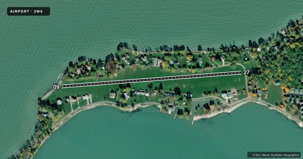
Airport sketch
Runways drawn to scale from FAA survey coordinates, rendered over satellite imagery. Not for navigation.
Approaches & charts
Services on the field
Fuel grades, oxygen, maintenance, ramp storage and lighting — as declared to the FAA by the airport operator.
Fuel & services
- Fuel
- Not available
- Oxygen (bottled)
- Not available
- Oxygen (bulk)
- Not available
- Airframe repair
- Not available
- Power plant repair
- Not available
Ramp & ground
- Transient storage
- Tie-down
- Landing fee
- No fee published
- Wind indicator
- Yes
- Segmented circle
- No
Fuel & FBOs
Cheapest 100LL and Jet A on the field and nearby. Always confirm with the FBO before taxi.
Airport notes
Surface conditions, obstructions, local procedures, lighting outages and other notes published with each FAA cycle.
General notes
- NMRS TREES & BLDGS IN CLOSE PROXIMITY TO RWY.
- EXP SGFNT WS & TURB ON APCH & DEP WHEN WIND EXCEEDS 10 KT.
- FOR CD CTC CLEVELAND APCH AT 216-352-2323.
- FOR WIND INDCR USE SEGMENTED CRC AT 3T7 ARPT.
- OCNL DEER, BIRDS, & OTR WILDLIFE ON & INVOF ARPT.
Approach & departure obstructions
- 09CTLG OBSTN EXCEEDS A 45 DEG SLP.
Other notes
- THIS AIRPORT HAS BEEN SURVEYED BY THE NATIONAL GEODETIC SURVEY.
- VFR ONLY.
- PRIOR CDN RQRD, ROPES & TEMPO TIEDOWNS NOT PRVDD.
- 09/27SOFT & WET IN SPRING.
VFR map & nearby airports
VFR sectional. Tap any ICAO chip to open that airport.
Key facts · 3W9
Answer card- ICAO
- 3W9
- Name
- MIDDLE BASS-EAST POINT
- Location
- MIDDLE BASS ISLAND, OHIO
- Elevation
- 582 ft MSL
- Traffic pattern altitude
- 1,582 ft MSL (1,000 AGL)
- Control tower
- Non-towered (use CTAF)
- Total runways
- 1
- Longest runway
- 09/27 · 2,085 ft
- Published ILS approaches
- 0
- Published frequencies
- 1
- Magnetic variation
- 7°
- Current flight rules
- VFR
- Current wind
- 260° at 12 kt
- Favored runway now
- RWY 27
Middle Bass-East Point (3W9) sits on Middle Bass Island, Ohio. Field elevation is 582 ft MSL. The airport has one runway. Runway 09/27 is 2,085 ft of turf, which is the longest runway on the field. There is no control tower. CTAF is 122.9. No ILS approaches are published. The published pattern altitude is not listed, so use the standard 1,000 ft AGL for light piston operations unless the current Chart Supplement says otherwise.
This is a VFR-only field. Prior coordination is required before arrival. There are no on-field FBOs listed in the facts, so plan to contact the airport operator directly or call the field on CTAF for current handling details. The published remarks also note that ropes and temporary tiedowns are not provided. Clearance delivery is handled through Cleveland Approach at 216-352-2323.
Expect a tight environment. Trees and buildings sit close to the runway. The published remarks also call out an obstruction near runway 09 that exceeds a 45 degree slope. The runway is soft and wet in spring. Wind shear and turbulence can be significant when wind exceeds 10 knots. Wildlife is also a factor here. For wind indication, use the segmented circle at 3T7 airport.