METAR & TAF 89D
89D does not publish a METAR.
Showing the nearest reporting station: KPCW (ERIE-OTTAWA INTL) · 9.8 NM away. Conditions at 89D may differ.
METAR · KPCW
Observed 20:55Z
KPCW 272055Z AUTO 26012KT 10SM CLR 27/22 A2980 RMK AO2
- Wind
- 260° @ 12 kt
- Visibility
- 10 SM
- Temp / Dew
- 27°C / 22°C
- Altimeter
- 29.80 inHg
- Clouds
- CLR
- Density alt
- 2,331 ft
- Ceiling
- Unlimited
- Rules
- VFR
Airport info & contacts
Manager on record, flight service, ARTCC, attendance schedule and pattern altitude — published by the FAA and refreshed every 28 days.
Location
- From city
- 1 NM NE
- VFR sectional
- DETROIT
- ARTCC
- ZOB · CLEVELAND
- NOTAM facility
- CLE (NOTAM-D)
Airport manager
- Name
- ROBERT QUINN
- Phone
- 419-503-0663
- Address
- 121 ADDISON ST BOX 469, KELLEYS ISLAND OH 43438
Flight service · Hours
- FSS CLE
- CLEVELAND1-800-WX-BRIEF
- Attendance
- Unattended
Frequencies
Tap any row to copy the frequency to your clipboard.
Runways & pattern
Full pagePattern entry · RWY 27
LEFT TRAFFICRunway end performance
| End | TORA | TODA | ASDA | LDA | VGSI | Approach lights | Obstruction |
|---|---|---|---|---|---|---|---|
| 09 | — | — | — | — | — | — | 55', trees, 329' from thr, 180' R of cntrln, slope 2 |
| 27 | — | — | — | — | — | — | 70', fence, 286' from thr, 129' R of cntrln, slope 1 |
Declared distances in feet. TORA = takeoff run available, TODA = takeoff distance, ASDA = accelerate-stop, LDA = landing distance.
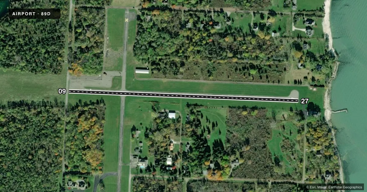
Airport sketch
Runways drawn to scale from FAA survey coordinates, rendered over satellite imagery. Not for navigation.
Approaches & charts
Services on the field
Fuel grades, oxygen, maintenance, ramp storage and lighting — as declared to the FAA by the airport operator.
Fuel & services
- Fuel
- Not available
- Oxygen (bottled)
- Not available
- Oxygen (bulk)
- Not available
- Airframe repair
- Not available
- Power plant repair
- Not available
Ramp & ground
- Transient storage
- Tie-down
- Landing fee
- Yes
- Customs
- Not available
- Lighting schedule
- SEE RMK
- Wind indicator
- Lighted
- Segmented circle
- No
Fuel & FBOs
Cheapest 100LL and Jet A on the field and nearby. Always confirm with the FBO before taxi.
Airport notes
Surface conditions, obstructions, local procedures, lighting outages and other notes published with each FAA cycle.
General notes
- DEER & BIRDS ON & INVOF ARPT.
- FOR CD CTC CLEVELAND APCH AT 216-352-2323.
Lighting notes
- ACTVT MIRL RWY 09/27 - CTAF.
Approach & departure obstructions
- 0910 FT ROAD, 12 FT DIST, 125 FT L/R.
- 27+10 FT ROAD, 0-92 FT DIST, 0-125 FT L; +4 FT PROPANE TANK, 104-120 FT DIST, 87-92 FT L; +18 FT HOUSE, 102-200 FT DIST, 94-125 FT L; +12 FT TREES, 106-136 FT DIST, 80 FT L.
- 09APCH SLP 7:1 TO DTHR DUE TO +54 FT TREE, 594 FT DIST, 139 FT R.
Other notes
- VFR OPNS ONLY.
- OWNERUNMON ARPT TRML 419-746-2228.
VFR map & nearby airports
VFR sectional. Tap any ICAO chip to open that airport.
Key facts · 89D
Answer card- ICAO
- 89D
- Name
- KELLEYS ISLAND LAND FLD
- Location
- KELLEYS ISLAND, OHIO
- Elevation
- 598.2 ft MSL
- Traffic pattern altitude
- 1,598.2 ft MSL (1,000 AGL)
- Control tower
- Non-towered (use CTAF)
- Total runways
- 1
- Longest runway
- 09/27 · 2,202 ft
- Published ILS approaches
- 0
- Published frequencies
- 1
- Magnetic variation
- 7°
- Current flight rules
- VFR
- Current wind
- 260° at 12 kt
- Favored runway now
- RWY 27
Kelleys Island Land Flld Airport sits on Kelleys Island in Ohio. Field elevation is 598.2 ft MSL. The airport has one runway. Runway 09/27 is 2,202 ft of asphalt. There is no control tower. Operations are VFR only. No ILS approaches are published.
Pattern altitude is not published. Use the standard 1,000 ft AGL for light piston operations unless the current Chart Supplement says otherwise. The field is small and the runway environment has close-in obstacles. Near runway 09 there is a road close to the threshold area. Near runway 27 there are roads, a propane tank, a house and trees close to the runway side. There is also a 54-foot tree near the 09 approach path that drives a steeper approach slope to the displaced threshold. Deer and birds are reported on and near the airport.
The airport terminal is unmonitored. The owner can be reached at 419-746-2228. CTAF is 122.9. Medium intensity runway lights on 09/27 are activated by the CTAF. For clearance delivery, contact Cleveland Approach at 216-352-2323. No on-field FBOs are listed. Verify fuel and services with the airport operator before arrival.