METAR & TAF 41D
41D does not publish a METAR.
Showing the nearest reporting station: KPTK (OAKLAND COUNTY INTL) · 1.6 NM away. Conditions at 41D may differ.
METAR · KPTK
Observed 18:53Z
KPTK 271853Z 29013KT 10SM BKN140 OVC200 29/19 A2979 RMK SLPNO T02930293
- Wind
- 290° @ 13 kt
- Visibility
- 10 SM
- Temp / Dew
- 29°C / 19°C
- Altimeter
- 29.79 inHg
- Clouds
- OVC
- Density alt
- 3,056 ft
- Ceiling
- 14,000 ft AGL
- Rules
- VFR
Airport info & contacts
Manager on record, flight service, ARTCC, attendance schedule and pattern altitude — published by the FAA and refreshed every 28 days.
Location
- From city
- 5 NM E
- VFR sectional
- DETROIT
- ARTCC
- ZOB · CLEVELAND
- NOTAM facility
- LAN (NOTAM-D)
Airport manager
- Name
- CRAN JONES
- Phone
- 248-752-7602
- Address
- 2541 TACKLES DR, WHITE LAKE MI 48386-1561
Flight service · Hours
- FSS LAN
- LANSING1-800-WX-BRIEF
- Attendance
- Unattended
Frequencies
Tap any row to copy the frequency to your clipboard.
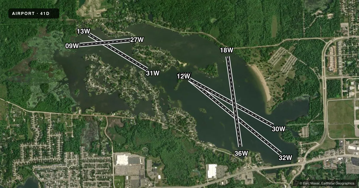
Runways & pattern
Full pagePattern entry · RWY 30W
LEFT TRAFFICAirport sketch
Runways drawn to scale from FAA survey coordinates, rendered over satellite imagery. Not for navigation.
Approaches & charts
Services on the field
Fuel grades, oxygen, maintenance, ramp storage and lighting — as declared to the FAA by the airport operator.
Fuel & services
- Fuel
- Not available
Ramp & ground
- Transient storage
- Not published
Fuel & FBOs
Cheapest 100LL and Jet A on the field and nearby. Always confirm with the FBO before taxi.
Airport notes
Surface conditions, obstructions, local procedures, lighting outages and other notes published with each FAA cycle.
General notes
- FOR CD CTC PONTIAC ATCT ON FREQ 118.25, WHEN ATCT CLSD CTC DETROIT APCH AT 734-955-1404.
- WHEN PTK ATCT IS OPEN OPS CONTINGENT UPON THE PROVISIONS OF THE LOA BEING ADHERED TO: ACFT OPRG IN/OUT OF 41D MUST OBTAIN PTK ATIS PRIOR TO CTCG PTK & COMMUNICATE WITH PTK ON FREQ 120.5 BFR ENTERING CLASS D ASP; PTK SHALL PRVD CLASS D SVCS WHILE ACFT ARE TRSNG TO/FM 41D & ARE VSB FM PTK; PTK DOES NOT PRVD ARPT TFC CTL SVCS AT 41D; PTK SHALL PRVD TFC INFO/ALERTS WORLKOAD PMTG.
VFR map & nearby airports
VFR sectional. Tap any ICAO chip to open that airport.
Key facts · 41D
Answer card- ICAO
- 41D
- Name
- MICHIGAN
- Location
- WHITE LAKE, MICHIGAN
- Elevation
- 980 ft MSL
- Traffic pattern altitude
- 1,980 ft MSL (1,000 AGL)
- Control tower
- Non-towered (use CTAF)
- Total runways
- 5
- Longest runway
- 14W/32W · 4,530 ft
- Published ILS approaches
- 0
- Published frequencies
- 1
- Magnetic variation
- –
- Current flight rules
- VFR
- Current wind
- 290° at 13 kt
- Favored runway now
- RWY 30W
Michigan Airport (41D) sits in White Lake, Michigan. Field elevation is 980 ft MSL. It has five water runways. The longest is 4,530 ft on 14W/32W. No control tower is listed. CTAF is 120.5.
No ILS approaches are published here. Pattern altitude is not published, so use the standard 1,000 ft AGL for light piston traffic unless the current Chart Supplement says otherwise. This is a water field, so plan for a seaplane arrival and make sure your water operations setup is current before you go.
Published remarks matter here. For clearance delivery, contact Pontiac Tower on 118.25. When the tower is closed, contact Detroit Approach at 734-955-1404. When Pontiac Tower is open, aircraft going in and out of 41D must get Pontiac ATIS first. Then contact Pontiac on 120.5 before entering Class D airspace. Pontiac provides Class D services while aircraft are transiting to and from 41D and are visible from Pontiac. Pontiac does not provide airport traffic control services at 41D.
There are no on-field FBOs listed. Check with the airport operator or the FBO directly by phone before arrival if you need current services. The field is in the Detroit metro area. Expect busy airspace and coordinate early.